
Climate Change Mechanisms: Natural and Anthropogenic Drivers of Global Climate Systems
Climate change results from a complex interplay of natural processes and anthropogenic factors that collectively influence Earth's climate system. Plate tectonics gradually reconfigures continents and ocean basins while creating mountain ranges that alter atmospheric circulation patterns. Variations in Earth's orbital parameters—eccentricity, obliquity, and precession—modify the distribution and intensity of solar insolation received at different latitudes. The chemical composition of the atmosphere plays a crucial role, with increasing concentrations of greenhouse gases including carbon dioxide (CO2) , methane (CH4) , and nitrous oxide (N2O) enhancing the natural greenhouse effect and contributing to global warming. Freshwater runoff modifications to ocean basins influence thermohaline circulation patterns, while solar output varies with sunspot activity cycles. Additionally, atmospheric aerosols—both natural and anthropogenic—alter Earth's radiative balance through direct scattering and absorption of radiation and indirect effects on cloud properties.
Plate Tectonics and Continental Configuration. Plate tectonics, also termed continental drift, describes the gradual movement of continental landmasses at rates of several centimeters per year—comparable to the rate of fingernail growth. During the late Proterozoic and early Paleozoic eras (approximately 540-500 million years ago), continents were widely dispersed along equatorial regions. These landmasses gradually converged through complex collision processes, culminating approximately 300 million years ago in the assembly of Pangaea, a supercontinent that incorporated nearly all of Earth's continental crust. This immense landmass began fragmenting around 200 million years ago during the early Jurassic period, initiating the slow dispersal of continents toward their present positions. The current continental configuration represents one phase of an ongoing supercontinent cycle—a recurring pattern of continental assembly, fragmentation, and re-assembly that operates over approximately 500-million-year timescales and profoundly influences long-term climate evolution.
The late Cretaceous period (approximately 80 million years ago) provides compelling evidence of plate tectonics' climate-altering influence (Crowley and North 1991). During this interval, three major continental blocks formed extensive contiguous land areas: the North America-Greenland-Eurasia assemblage; the South America-Antarctica-India-Australia connection; and the African continental mass (Figure 8.6). The global ocean comprised a single vast Pacific basin, with the Atlantic Ocean yet to form—North America and Europe remained proximate, as did South America and Africa. India and Australia maintained connections with Antarctica, and the Indian Ocean had not developed. Global sea level stood approximately 100-200 meters higher than present, inundating extensive portions of western Europe, northern Africa, and interior North America with extensive shallow epicontinental seas. The southerly position of Africa, India, and Australia prevented development of a circumpolar Antarctic current; instead, open passageways between North and South America and between Eurasia and Africa facilitated development of the Tethys Sea—a shallow equatorial seaway that enabled circumglobal ocean circulation. Global climate during this interval was substantially warmer than present, particularly at high latitudes, with atmospheric CO2 concentrations reaching two to nine times pre-industrial levels. This elevated CO2, combined with altered oceanic heat transport mechanisms, contributed to the observed warming.
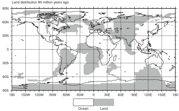
Figure 8.6 illustrates the distribution of land and ocean basins during the late Cretaceous (80 million years before present). Continental outlines superimposed on the paleogeographic reconstruction depict modern coastlines for reference, highlighting the dramatic differences in continental configuration. The figure demonstrates the extensive shallow seaways flooding continental interiors and the absence of major ocean basins that characterize modern geography. Data for this reconstruction derive from Hay et al. (1999) and were provided by the National Center for Atmospheric Research (NCAR) , Boulder, Colorado.
Continental Drift and Ocean Basin Evolution. Since the late Cretaceous, continents have progressively migrated to their modern geographic positions through continued plate tectonic movements. The westward drift of the Americas progressively opened the Atlantic Ocean, initially as a narrow seaway that widened through seafloor spreading. Africa migrated northward to converge with Europe, gradually closing the western Tethys Seaway, while the Indian subcontinent drifted northward at rates exceeding 15 centimeters per year before colliding with Asia. This collision, combined with northward movement of Australia and emergence of the Central American isthmus, completely closed the equatorial Tethys circulation pathway. Formation of the North Atlantic, South Atlantic, and Indian Oceans enabled development of subtropical gyres—large-scale ocean circulation cells that characterize modern ocean basins at these latitudes. The opening of Drake Passage between South America and Antarctica, coupled with northward migration of India and Australia, established the Antarctic Circumpolar Current (ACC) —the world's largest ocean current system that now flows unimpeded around Antarctica. These ocean circulation changes substantially altered meridional heat transport and global climate patterns. Development of the Antarctic Circumpolar Current may have reduced warm water transport toward Antarctica, thermally isolating the continent and facilitating initial Antarctic glaciation approximately 34 million years ago at the Eocene-Oligocene boundary.
Orogenic Climate Effects: Mountain Building and Atmospheric Circulation. Mountain building (orogenesis) introduces additional climate-forcing mechanisms through multiple spatial and temporal scales. Locally, elevated terrain experiences temperature reductions following the environmental lapse rate—approximately 6.5°C per kilometer elevation gain under standard atmospheric conditions. Orographic precipitation patterns develop as air masses encounter topographic barriers: windward slopes receive enhanced precipitation through adiabatic cooling and condensation, while leeward regions experience rain shadow effects with substantially reduced precipitation. The Himalayan rain shadow creates arid conditions across the Tibetan Plateau and interior Asia, while the Sierra Nevada produces stark precipitation contrasts between western slopes and the Great Basin desert.
At regional and hemispheric scales, major mountain barriers modify atmospheric circulation by disturbing the prevailing westerly wind flow characteristic of mid-latitudes. High mountain ranges and extensive plateaus physically block the west-to-east progression of jet streams—narrow bands of strong upper-level winds that guide weather systems. The eastward airflow deflects around elevated terrain, intensifying Rossby waves (planetary-scale meanders in the jet stream) that control the distribution of warm and cold air masses. These topographic modifications enhance meridional (north-south) exchange of air, influencing storm tracks and precipitation patterns across entire continents.
Seasonal heating contrasts over uplifted terrain substantially modify monsoon circulation systems. During summer, intense solar radiation heats high-elevation plateaus, warming the overlying air and reducing its density. This generates rising motion and creates thermal lows at the surface. Air flows into these low-pressure centers from surrounding regions, bringing moisture that fuels summer monsoon precipitation. The Tibetan Plateau heating drives the Asian monsoon—Earth's most vigorous monsoon system—by establishing pressure gradients that draw moist air from the Indian and Pacific Oceans. Winter conditions reverse this pattern: intense radiative cooling over high plateaus produces cold, dense air that subsides, generating surface thermal highs and promoting outward, divergent airflow that suppresses precipitation.
Geologic Evidence of Tectonic Climate Forcing. Extensive geologic evidence documents how Cenozoic uplift over the past 10-40 million years has altered regional temperature and precipitation patterns (Kutzbach et al. 1989; Ruddiman and Kutzbach 1989; Ruddiman et al. 1989, 1997; Prell and Kutzbach 1992; Zhisheng et al. 2001). The Tibetan Plateau, Earth's largest and highest elevated region, encompasses more than 2 million square kilometers with average elevation of approximately 4.5 kilometers above sea level. The Himalayan Mountains form a dramatic narrow range along the plateau's southern margin, containing Earth's highest peaks including Mount Everest. This immense topographic feature results from the continuing collision between the Indian and Eurasian plates that began 40-50 million years ago, with crustal thickening and uplift continuing today at rates of several millimeters per year.
Formation of the Himalayas and Tibetan Plateau fundamentally transformed Asian climate, particularly strengthening the Asian monsoon system. Prior to the India-Asia collision, Asia's limited continental extent and low elevation precluded development of strong land-sea temperature contrasts, resulting in weak monsoonal circulation. Progressive Neogene uplift intensified the monsoon through multiple mechanisms: elevated plateau heating strengthened summer thermal lows, while the topographic barrier enhanced orographic precipitation along the Himalayan front. These changes dramatically increased moisture transport onto the Asian continent, supporting development of diverse ecosystems from tropical forests to temperate woodlands. Paleoclimate proxy records from loess sequences, lake sediments, and fossil assemblages document this monsoon intensification through the Miocene and Pliocene epochs.
In western North America, uplift over the past 15 million years has constructed the Sierra Nevada and Rocky Mountain ranges, with the high Great Basin and Colorado Plateau occupying the intervening region. This Cordilleran mountain building has profoundly modified regional climate patterns. The Sierra Nevada creates an intense rain shadow responsible for the aridity of the Great Basin and southwestern deserts. The Colorado Plateau uplift influenced development of the Colorado River system and modified regional precipitation patterns. These topographic changes, combined with global cooling through the late Cenozoic, have shaped the distinctive climate regimes that characterize modern western North America—from Mediterranean-type climates in coastal California to continental deserts and high-elevation forest ecosystems.
Date added: 2026-09-24; views: 1;