
Ocean Dynamics: Upwelling, Deep Water Masses, and Global Circulation
Upwelling and Downwelling 6.4. When dense water from the surface sinks and reaches a level at which it is denser than the water above but less dense than the water below, it spreads horizontally as more water descends behind it. At the surface, water moves horizontally into the region where sinking is occurring. The dense water that has descended displaces water upward, completing the cycle.
Because water is a fixed quantity in the oceans, it cannot be accumulated or removed at given locations without movement of water between those locations. This concept is called continuity of flow. Areas of thermohaline circulation where water sinks are called downwelling zones; areas of rising waters are upwelling zones. Downwelling is a mechanism that transports oxygen-rich surface water to depth, where it is needed for the deep-living animals. Upwelling returns water with dissolved, decay-produced nutrients that have accumulated at depth to the surface, where they act as fertilizers to promote the production of more oxygen by photosynthesis in the sunlit surface waters.
Upwelling and downwelling refer to vertical motion of water upward or downward. They are present in thermohaline circulation but can also be caused by wind-driven surface currents. When the surface waters are driven together by the wind or against a coast, a surface convergence is formed. Water at a surface convergence sinks, or downwells. When the wind blows surface waters away from each other or away from a coast, a surface divergence occurs and water from below is upwelled (fig. 6.13). During the slow movement of water from surface to depth and back, the water continually mixes with adjacent layers of water, gradually exchanging chemical and physical properties.
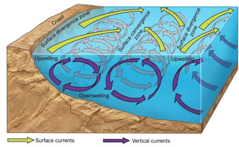
Fig. 6.13. Upwelling and downwelling are related to horizontal motions of water at the sea surface. Downwelling occurs where surface currents converge, and upwelling occurs where surface currents diverge.
The speed of upwelling and downwelling water is about 0.1 to 1.5 m (5 ft) per day. Compare this speed with that of oceanic surface currents, which reach speeds of 1.5 m/s. Horizontal movement at mid-ocean depth due to the thermohaline flow is about 0.01 cm (0.004 in) per second. Water caught in this slow but relentlessly moving cycle may spend 1000 years at the greater ocean depths before it again reaches the surface.
Chemical Tracers. Chemical tracers are substances that occur in small amounts in seawater; they have no effect on water motion but can be used to identify kinds of water moving through the ocean system. Transient tracers are substances that change their distributions with time and have usually been added to the oceans by human means. When carefully sampled and analyzed, these transient tracers provide us with the quantitative data used to form computer and mathematical models of water pathways in the oceans.
Atmospheric testing of nuclear weapons in the late 1950s and early 1960s produced radioactive materials that still persist in traces in the oceans. Research carried out by the Geochemical Ocean Sections (GEOSECS) program in 1972–73 showed that water containing radioactive substances from the sea surface had reached the bottom of the North Atlantic at 5000 m (16,400 ft) depth north of 40°N. South of this latitude no radioactive substances were present below 3000 m (10,000 ft), indicating a much faster rate of downwelling transport than was previously thought to occur.
The 1981 Transit Tracers in the Ocean (TTO) cruises found that the radioactive material had moved southward since GEOSECS and was found distributed from ocean surface to ocean floor as far south as 30°N. South of this latitude the North Atlantic was free of radioactive substances at depths below 2000 m (6500 ft).
Current work on radioactive substances focuses on tritium, a heavy isotope of hydrogen left from these same tests. Because tritium is chemically hydrogen, it is present in the oceans as part of the water molecules and is therefore the perfect tracer for water movement. Tritium is radioactive, making it easily traceable, and has a half-life of 12.45 years; it decays to an inert isotope of helium. It is possible to compute the time since a water parcel was last at the surface by measuring the tritium-helium isotope concentrations in that water. These age calculations are most accurate for time periods of less than ten years and for water movements in shallow areas, where there is the least background of naturally occurring helium. Layers of constant density along which water tends to move and mix have been identified by this method in the North Atlantic.
The Layered Oceans 6.5. Oceanographers have taken salinity and temperature measurements with depth from many surface positions and for many years. Gradually they accumulated sufficient data to identify the layers of water that make up each ocean and the surface source of the water forming each layer. The structure of an ocean is determined by the properties of the layers of water present under the sea surface.
Each layer received its characteristic salinity, temperature, and density at the surface. The water's density controls the depth to which the water sinks; the thickness and horizontal extent of each layer are related to the rate of its formation and the size of the surface region from which it came. Water that sinks from the surface to spread out at depth eventually rises at another location or slowly mixes with adjacent layers. In all cases, water that sinks to depth displaces an equivalent volume of water upward toward the surface at some other location so that the oceans' vertical circulation may continue.
The layers of water described above are associated with depth zones: surface, intermediate, deep, and bottom.
- The surface zone extends to 200 m (650 ft).
- The intermediate zone lies between 300–2,000 m (1000–6500 ft).
- Deep water is found between 2000 and 4000 m (6500–13,000 ft).
- Bottom water is the water below 4000 m (13,000 ft).
The Structure of the Atlantic and Arctic Oceans. The properties of the layers of water making up the Atlantic Ocean are shown in figure 6.14. At the surface in the North Atlantic, water from high northern latitudes moves southward, while water from low latitudes moves northward along the coast of North America and then east across the Atlantic. These waters converge in areas of cool temperatures and high precipitation at approximately 50°N to 60°N in the Norwegian Sea and at the boundaries of the Gulf Stream and the Greenland and Labrador currents. The resulting mixed water has a salinity of about 34.9‰ and a temperature of 2° to 4°C. This water, known as North Atlantic deep water, sinks and moves southward.
North Atlantic deep water from the Norwegian Sea moves down the east side of the Atlantic, while water formed at the boundary of the Labrador Current and the Gulf Stream flows along the western side. Above this water at 30°N, a low-density layer of very salty (36.5‰) but very warm (25°C) surface water remains trapped by the circular movement of the major oceanic surface currents. Between this surface water and the North Atlantic deep water lies water of intermediate temperature (10°C) and salinity (35.5‰). This water is a mixture of surface water and the upwelled colder, saltier water from the subtropical regions. It moves northward to reappear at the surface south of the convergence in the North Atlantic.
Near the equator, the upper boundary of the North Atlantic deep water is formed by water produced at the convergence centered about 40°S. This is Antarctic intermediate water. Because it is warmer (5°C) and less salty (34.4‰) than the North Atlantic deep water, it is less dense and remains above the denser and saltier water below. Along the edge of Antarctica very cold (-0.5°C), salty (34.8‰), and dense water is produced at the surface by sea ice formation during the Southern Hemisphere's winter. This is Antarctic bottom water, the densest water produced in the world's oceans.
After it descends to the ocean floor, it begins to move northward. When it meets North Atlantic deep water it creeps beneath it and continues to move northward through the deep South Atlantic ocean basins west of the Mid-Atlantic Ridge. Antarctic bottom water does not accumulate enough thickness to be able to flow over the mid-ocean ridge system into the basins on the African side of the ridge; it is confined to the deep basins on the west side of the South Atlantic and has been found as far north as the equator.
At the same time, the North Atlantic deep water trapped between the Antarctic bottom and intermediate waters rises to the ocean's surface in the area of the 60°S divergence. As it reaches the surface it splits; part moves northward as South Atlantic surface water and Antarctic intermediate water; part moves southward toward Antarctica, to be cooled and modified to form Antarctic bottom water. A mixture of North Atlantic deep water and Antarctic bottom water becomes the circumpolar water for the Southern Ocean as it flows around Antarctica.
Warm (25°C), salty (36.5‰) surface water in the South Atlantic is also caught by the circular current pattern at the surface and is centered about 30°S. Below the southern tips of South America and Africa the water flows eastward, driven by the prevailing westerly winds, which move the water around and around Antarctica.
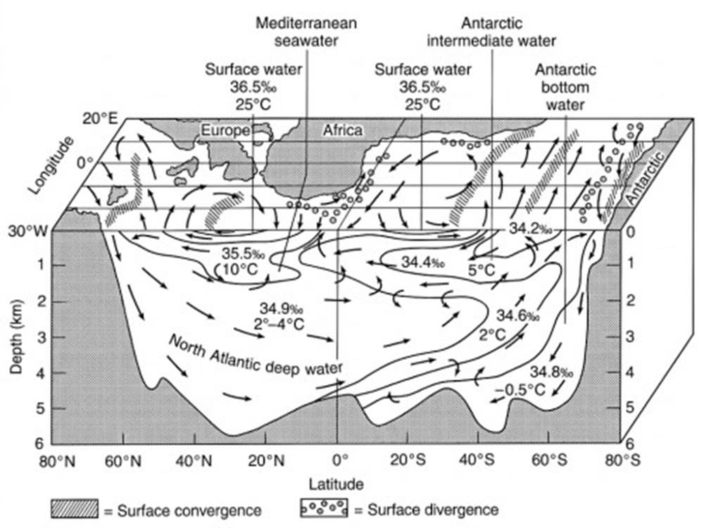
Fig. 6.14. The anatomy of the Atlantic Ocean. Surface and subsurface circulation are related here. The surface currents converge to produce downwelling; water sinks to its density level and flows horizontally. Water at depth rises under zones of surface divergence.
Because the Atlantic Ocean is a narrow, confined ocean of relatively small volume but great north-south extent, the water types are readily identifiable and the movement of the layers can be followed quite easily. In addition, the bordering nations of the Atlantic have had a long-standing interest in oceanography, so the vertical circulation and layering of the Atlantic are both the most studied and the best understood of all the oceans.
Some oceanographers consider the Arctic Ocean to be an extension of the North Atlantic, but it differs from the Atlantic Ocean in many significant ways. About one-third of its area, 8 × 10⁶ km² (3.1 × 10⁶ mi²), is covered by extensive continental shelves, the widest of any ocean. Two basins, the Eurasian to the east and the Canadian to the west, occupy the central portion of the ocean; they are separated by the Lomonosov Ridge extending due north from Greenland (fig. 6.15). The Eurasian basin is the deeper basin, 5000 m (16,400 ft); it is connected to the North Atlantic through a gap in the continental shelf between Spitsbergen and Greenland. The larger, shallower Canadian basin is about 3800 m (12,450 ft) deep. Both basins contain spreading centers that are extensions of the North Atlantic Ridge system.
Arctic Ocean Water Masses. The density of the Arctic Ocean water is controlled more by salinity than by temperature. Its surface layer is formed from low-salinity water entering from the Bering Sea, fresh water from Siberian and Canadian rivers, and seasonal melting of sea ice. The surface layer from these combined sources is about 80 m (250 ft) deep and has a low salinity (32.5‰) and a low temperature (-1.5°C). Below the surface layer, salinity increases with depth in the halocline layer, 200 m (650 ft) thick, to reach 34.5‰ at its base. The cold, salty water of the halocline layer is produced by the annual freezing and formation of sea ice over the continental shelves. This water sinks and moves across the shelves to spread out in the central ocean basins.
West of Spitsbergen, North Atlantic water (2°C and 35‰) enters the Arctic Ocean and is cooled as it flows under the halocline and fills the Arctic Ocean basins. It upwells along the edge of the continental shelves, mixing with the water formed during freezing, and exits the Arctic as water of 0.5°C temperature and 34.9‰ salinity along the edge of the shelf adjacent to Greenland. This exiting water moves down the coast of Greenland and enters the North Atlantic south of Greenland and Iceland, where it combines with Gulf Stream water to form North Atlantic deep water.
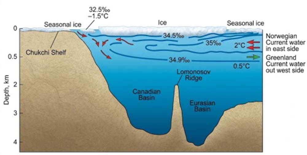
Fig. 6.15. The Arctic Ocean. Water is supplied to a shallow surface layer by the Atlantic Ocean's Norwegian Current. Water exits the Arctic Ocean into the Atlantic Ocean by the Greenland Current. This circulation is confined almost entirely to the upper 500 meters of the Arctic Ocean.
Many aspects of the structure of the Arctic Ocean are still a puzzle. Approximately 70% of the total Arctic Ocean observations by all nations to date were made by the former Soviet Union. Since the cessation of the Cold War, detailed bathymetric and water column data are being declassified and made available to the Arctic research community. One data set contained 1.3 million salinity and temperature measurements taken over a period of many years from icebreakers, drifting ice camps, and buoys. The data are being distributed in a four-volume U.S.-Russian Arctic Atlas. The first volume was released in January of 1997.
More than a hundred years after the Norwegian vessel Fram was frozen into the Arctic ice (see the prologue), the Canadian Coast Guard icebreaker Des Groseilliers became the second ship to be intentionally left in the Arctic ice. The icebreaker was frozen into the ice in October 1997, 248 km (400 mi) north of Prudhoe Bay, Alaska. For the next year the 100-m- (300-ft-) long Des Groseilliers acted as hotel and supply base for the Surface Heat Budget of the Arctic Ocean (SHEBA) program (fig. 6.16). The data from studies of air-sea exchange processes that affect Arctic Ocean heat budgets are expected to give scientists a better understanding of the role the Arctic Ocean plays in global climate changes (see chapter 7).
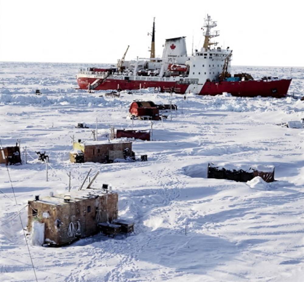
Fig. 6.16. The Canadian Coast Guard icebreaker Des Groseilliers serves as the support base for SHEBA research huts on the Arctic ice.
The Structure of the Pacific Ocean. In the vast Pacific Ocean waters that sink from relatively small areas of surface convergences lose their identity rapidly, making the layers difficult to distinguish. Antarctic bottom water forms in small amounts along the Pacific rim of Antarctica, but it is quickly lost in the great volume of the Pacific Ocean. The deeper water of the South Pacific Ocean is the common mixture of the Antarctic circumpolar flow.
Because the North Pacific is isolated from the Arctic Ocean, only a small amount of water comparable to North Atlantic deep water can be formed. In the extreme western North Pacific, convergence of the southward-flowing cold water from the Bering Sea and the Sea of Okhotsk and the northward-moving water from the lower latitudes produces a small volume of water that sinks to mid-depths. There is no dramatic source of deep water similar to that found in the North Atlantic. Warm, salty surface water occurs at subtropical latitudes (30°N and 30°S) in each hemisphere, and Antarctic intermediate water is produced in small quantities, but its influence is small. Deep-water movements in the Pacific are sluggish, and conditions are very uniform below 2000 m (6600 ft).
The Structure of the Indian Ocean. Because the Indian Ocean is principally an ocean of the Southern Hemisphere, there is no counterpart of the North Atlantic deep water. Small amounts of Antarctic bottom water are soon lost; the deeper waters tend to be a fairly uniform mixture of Antarctic circumpolar water brought into the Indian Ocean by the Antarctic circumpolar current. There is a small amount of Antarctic intermediate water, and in the subtropics a lens of warm, salty water occurs at the surface.
Bordering Seas. Two small but specific water types from bordering seas are readily identifiable, one in the North Atlantic and one in the Indian Ocean. The water from the Mediterranean Sea has a temperature of about 13°C and a salinity of 37.3‰ as it leaves the Strait of Gibraltar. This water, mixing with Atlantic Ocean water, creates a water mixture that sinks and finds its own density in the North Atlantic at approximately 1000 m (3300 ft) in depth. The influence of Mediterranean water can be traced 2500 km (1500 mi) from the Strait of Gibraltar before it is lost through modification and mixing. In the Indian Ocean, the initially very salty (40‰–41‰) water from the Red Sea has been found in a spreading layer at 3000 m (10,000 ft) depth more than 200 km (124 mi) south of its source.
Studies to determine where and how the deep water of the Mediterranean is formed were made in the 1980s and again in 1995. The Mediterranean Sea is divided into east and west basins at the Strait of Sicily (fig. 6.17). Deep and intermediate Mediterranean waters formed in the east basin move through the Strait of Sicily into the west basin and then through the Strait of Gibraltar into the Atlantic Ocean. The 1980 studies showed that high evaporation rates and winter cooling in the southern Adriatic Sea caused surface water to sink, and this water then moved into the east basin and from there into the west basin on its way to the Atlantic. The 1995 studies indicate that the source of the east basin water is no longer the Adriatic Sea; instead the water is being formed in the Aegean Sea. The Aegean Sea water is saltier and denser than that produced in the Adriatic Sea, and the Aegean water is now displacing older Adriatic water upward and westward into the Atlantic Ocean. It appears that small climate changes in the eastern Mediterranean Sea affect winter cooling and evaporation rates and play a significant role in the location and strength of the processes that produce the deep waters of the Mediterranean. Oceanographers are interested in what happens in the Mediterranean Sea because the forces that drive the Mediterranean system are comparable to the larger-scale processes governing the open ocean; thus, the Mediterranean Sea can be used as a model for the larger ocean system.
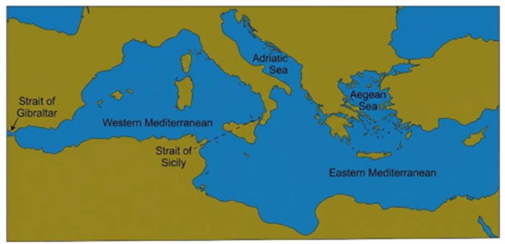
Fig. 6.17. A line through the Strait of Sicily separates the Mediterranean Sea into the Western Mediterranean basin and the Eastern Mediterranean basin. Deep and intermediate waters are formed in the eastern basin, move through the Strait of Sicily into the western basin, continue westward and exit through the Strait of Gibraltar into the Atlantic Ocean. Before 1987 cool, high-salinity, deep water was formed principally in the Adriatic Sea; by the winter of 1995, the source of this water had changed to the Aegean Sea.
Comparing the Oceans. Temperature and salinity distributions as functions of depth are shown in figure 6.18 for each of the three oceans. The distributions of Atlantic Ocean salinity and temperature values form patterns with depth (fig. 6.18a,b) that are clearly identifiable. Salinity values in the Pacific (fig. 6.18c,d) identify the high-salinity surface water lenses and the mixture of Antarctic bottom water and circumpolar deep water, with a salinity of about 34.7‰ and a temperature of about 1°C. A minor intrusion of low-salinity water in the north is the result of the surface convergence in the far northwestern Pacific. Note the large volume of deep water that shows a uniform salinity in this ocean. Temperature values also follow a less definite pattern, emphasizing the uniformity of most of this deep water. The Indian Ocean values in figure 6.18e,f resemble those for the South Atlantic, without the presence of water that is comparable to North Atlantic deep water.
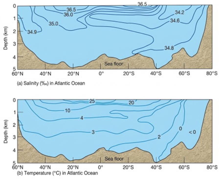
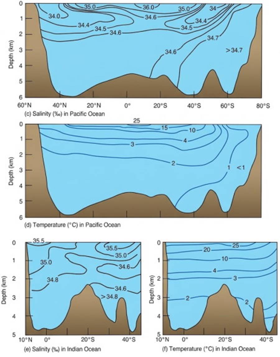
Fig. 6.18. Mid-ocean salinity and temperature profiles of the Atlantic, Pacific, and Indian oceans. Temperature and salinity are shown as functions of depth and latitude. (a) Salinity (‰) in Atlantic Ocean; (b) Temperature (°C) in Atlantic Ocean; (c) Salinity (‰) in Pacific Ocean; (d) Temperature (°C) in Pacific Ocean; (e) Salinity (‰) in Indian Ocean; (f) Temperature (°C) in Indian Ocean.
Internal Mixing. There is little vertical mixing between the water types that form the oceans' internal layers because, if a parcel of water is displaced vertically by turbulence, buoyancy forces tend to return the parcel of water to its original density level. Horizontal mixing is more efficient than vertical mixing because a parcel of water displaced horizontally along a surface of constant density remains at its new position and shares its properties with the surrounding water.
In areas under warm, high-salinity surface water with an appreciable salinity and temperature decrease with depth, there are internal vertical mixing processes that occur despite the stability of the water column. Vertical columnar flows, approximately 3 cm (5 in) in diameter, are called salt fingers; they develop and mix the water vertically, causing a stair-step salinity and temperature change with depth. This phenomenon is caused by the ability of seawater to gain or lose heat faster by conduction than it gains or loses salt by diffusion. This causes the density of the vertically moving water to change relative to that of the surrounding water and it is propelled either up or down. Salt fingers mix water over limited depths, creating homogeneous layers 30 m (100 ft) thick. These layers exist from about 150 to 700 m (500–2300 ft) deep and are estimated to occur over large areas of the oceans when the required conditions are present.
Date added: 2026-11-09; views: 3;