
Current Speed, Western Intensification, and Ocean Eddies
Current Speed. Wind-driven open-ocean surface currents move at speeds that are about 1/100th of the wind speed measured 10 m (30 ft) above the sea surface. The water moves between 0.25 and 1.0 knot, or 0.1 to 0.5 m/s (0.3–1.5 ft/s). Currents flow faster when a large volume of water is forced to flow through a narrow gap. For example, both the North and South Atlantic Equatorial Currents flow into the Caribbean Sea, then into the Gulf of Mexico, and finally exit to the North Atlantic as the Florida Current through the narrow gap between Florida and Cuba. The Florida Current's speed may exceed 3 knots, or 1.5 m/s (5 ft/s).
Major ocean currents transport very large volumes of water. For example, the Gulf Stream's transport rate to the northeast is about 55 × 10⁶ m³/s (1.9 × 10⁹ ft³/s); this rate is more than 500 times the flow of the Amazon River. The flow is distributed over the width and depth of the current. When the cross-sectional area of the current expands, the current slows down; when the cross-sectional area decreases, the current speeds up. Speed of flow then is not always directly related to surface wind speed but can be affected by the depth and width of the current as determined by land barriers, by the presence of another current, or by the rotation of the Earth, as explained in the next section, "Western Intensification."
Western Intensification. In the North Atlantic and North Pacific the currents flowing on the western side of each ocean tend to be much stronger, deeper, and narrower in cross section than the currents on the eastern side. This phenomenon is known as the western intensification of currents. The Gulf Stream and Kuroshio currents are faster and narrower than the Canary and California currents, although both the eastern and western currents transport about the same amount of water in order to preserve continuity of flow. Western intensification of currents traveling from low to high latitudes is related to three factors:
1. an increase in the Coriolis effect with latitude;
2. the changing strength and direction of the east-west wind field (trade winds and westerlies) with latitude;
3. and the friction between landmasses and ocean water currents.
These factors cause a compression of the currents toward the western side of the oceans, where water is moving from lower to higher latitudes. This compression requires that the current speed increase in order to transport the amount of water that circulates about the gyre. On the eastern side of the gyre, where currents are moving from higher to lower latitudes, the currents are stretched in the east-west direction. Here the current speed is reduced, but it still transports the required volume of water.
Fast-flowing, western-boundary currents move warm equatorial surface water to higher latitudes. Both the Gulf Stream and the Kuroshio Current bring heat from equatorial latitudes to moderate the climates of Japan and northern Asia (in the case of the Kuroshio) and the British Isles and northern Europe (in the case of the Gulf Stream, via the North Atlantic and Norwegian currents). Western intensification is observed in the South Pacific and South Atlantic, because both Africa and South America deflect portions of the West Wind Drift and create strong currents on the eastern sides of these oceans. The deflection of water from the Atlantic's South Equatorial Current to the Northern Hemisphere weakens the intensification of the Brazil Current and strengthens the Gulf Stream. The flow of water from the Pacific to the Indian Ocean through the islands of Indonesia also helps to prevent the development of strongly flowing currents on the west side of Southern Hemisphere oceans.
Eddies. When a narrow, fast-moving current moves into or through slower-moving water, the force of its flow displaces the quieter water and captures additional water as it does so. The current oscillates and develops waves along its boundary that are known as meanders. These meanders break off to form eddies, or packets of water moving with a circular motion; eddies take with them energy of motion from the main flow and gradually dissipate this energy through friction.
As the Gulf Stream moves away from the North American coast it is likely to develop a meandering path. The western edge of the Gulf Stream develops oscillations, and the indentations are filled by cold water from the Labrador Current side. When these indentations pinch off they become counterclockwise rotating cold-water eddies that are displaced through the Gulf Stream and into the warm-water core of the gyre. Bulges at the western edge of the Gulf Stream are filled with warm Gulf Stream water. When these bulges are cut off they become warm-water clockwise rotating eddies drifting into cold water, to the west and north of the Gulf Stream. Follow these processes in figures 8.7 and 8.8.
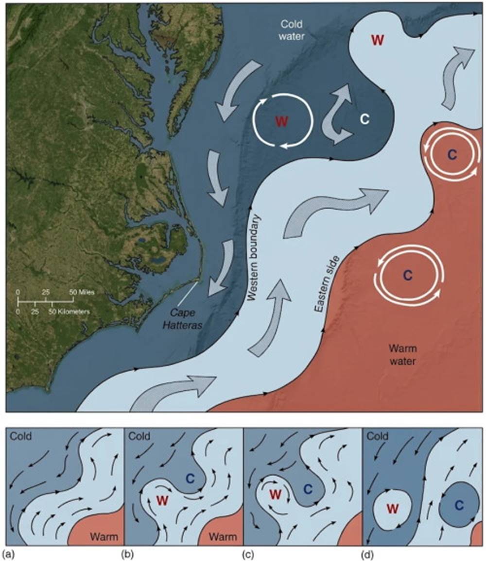
Fig. 8.7. The western boundary of the Gulf Stream is defined by sharp changes in current velocity and direction. Meanders form at this boundary after the Gulf Stream leaves the U.S. coast at Cape Hatteras. The amplitude of the meanders increases as they move downstream (a and b). In time, the current flow pinches off the meander (c). The current boundary re-forms, and isolated rotating cells of warm water (W) wander into the cold water, while cells of cold water (C) drift through the Gulf Stream into the warm water (d).
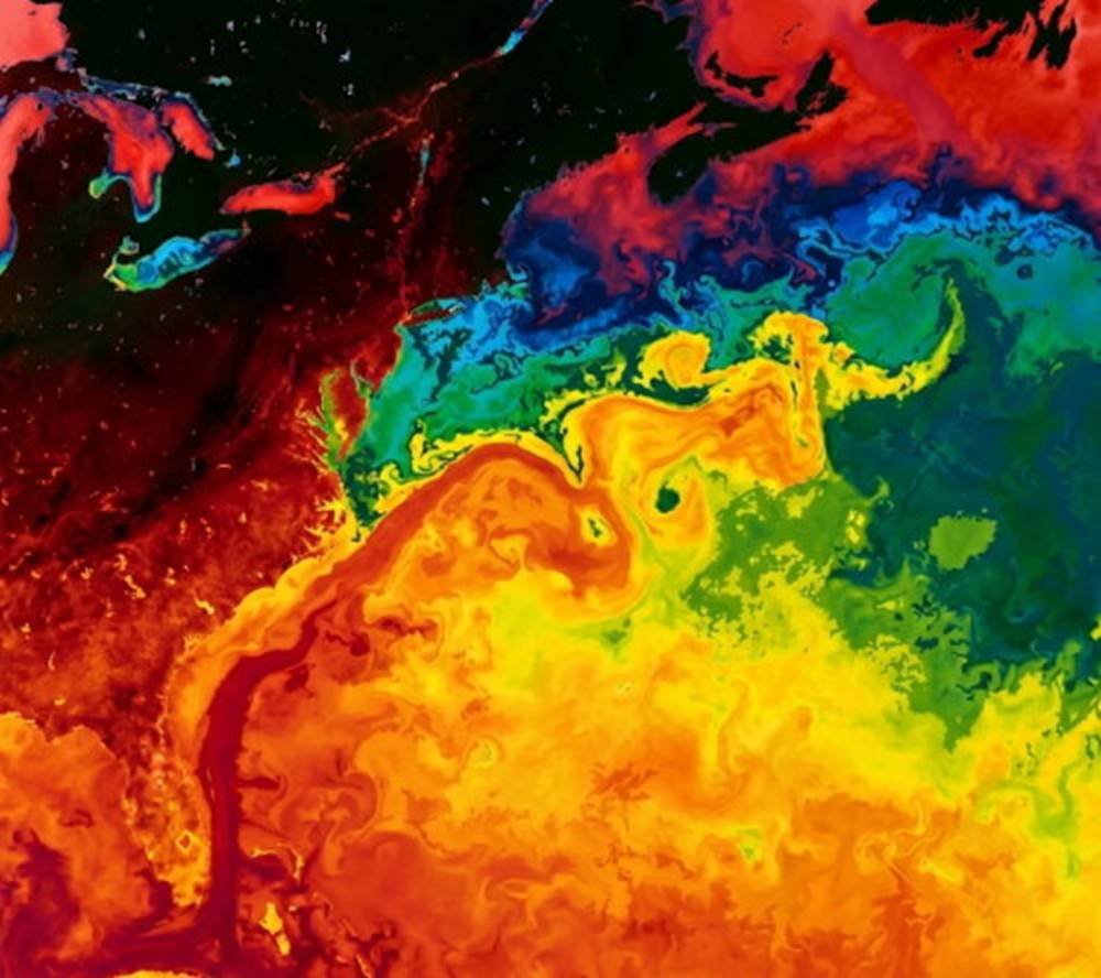
Fig. 8.8. A satellite image of the sea-surface reveals the warm (orange and yellow) and cold (green and blue) eddies that spin off the Gulf Stream. (Reddish blue areas at the top are the coldest waters.) These eddies may stir the water column right down to the ocean floor, kicking up blizzards of sediment.
These eddies may maintain their physical identity for weeks as they wander about the oceans; they are especially numerous in the area north of the Sargasso Sea. Current meanders and eddy formation produce surface flow patterns that differ markedly from the uniform current flows shown on current charts. These charts show average current flow, not daily or weekly variations.
Large and small eddies generated by horizontal flows or currents exist in all parts of the oceans; these eddies are of varying sizes, ranging from ten to several hundred kilometers in diameter. Each eddy contains water with specific chemical and physical properties and maintains its identity and rotational inertia as it wanders through the oceans. Eddies may appear at the sea surface or be embedded in waters at any depth.
Eddies rotate in a clockwise or counterclockwise direction. They stir the ocean until they gradually dissipate because of fluid friction, losing their chemical and thermal identity and their energy of motion. By testing the water properties of an eddy, oceanographers are able to determine the eddy's place of origin. Small surface eddies found 800 km (500 mi) southeast of Cape Hatteras in the North Atlantic have been found with water properties of the eastern Atlantic near Gibraltar more than 4000 km (2500 mi) away. Eddies from the Strait of Gibraltar are formed in the salty water of the Mediterranean as it sinks and spreads out into the Atlantic 500–1000 m (1600–3300 ft) down; these eddies have been nicknamed "Meddies." Deep-water eddies near Cape Hatteras may come from the eastern and western Atlantic, the Caribbean, or Iceland. Researchers estimate that some of these eddies are several years old; age determination is based on drift rates, distance from source, and biological consumption of oxygen.
The rotational water speed in the large eddies that form at the western boundary of the Gulf Stream is about 0.51 m/s (1 knot), but because of the water's density, the force of the flow is similar to that generated by a 35-knot wind. The diameter of the eddies may be as much as 325 km (200 mi), and their effect may reach to the sea floor. At the sea floor the rotation rate is zero; therefore a few meters above the bottom the speed of rotation diminishes very rapidly, and considerable turbulence is generated as the energy of the eddy is dissipated. These eddies are similar in many ways to the winds rotating about atmospheric pressure cells, and they are sometimes called abyssal storms.
As the eddies wander through the oceans, they stir up bottom sediments, producing ripples and sand waves in their wakes; they also mix the water, creating homogeneous water properties over large areas. Eventually the eddies lose their energy to turbulence and blend into the surrounding water.
Eddies constantly form, migrate, and dissipate at all depths. Eddy motion is superimposed on the mean flow of the oceans. To understand the role of eddies in mixing the oceans we need more data and better tracking of eddy size, position, and rate of dissipation. Satellites are important tools for detecting surface eddies because they can precisely measure temperature, increased elevation, and light reflection of the sea surface (see fig. 8.9). Deep-water eddies are monitored by using instruments designed to float at a mid-depth density layer. The instruments are caught up in the eddies, moving with them and sending out acoustic signals that are monitored through the sofar channel. In this way the rate of deep-water eddy formation, the numbers of major eddies, their movements, and their life spans can be observed.
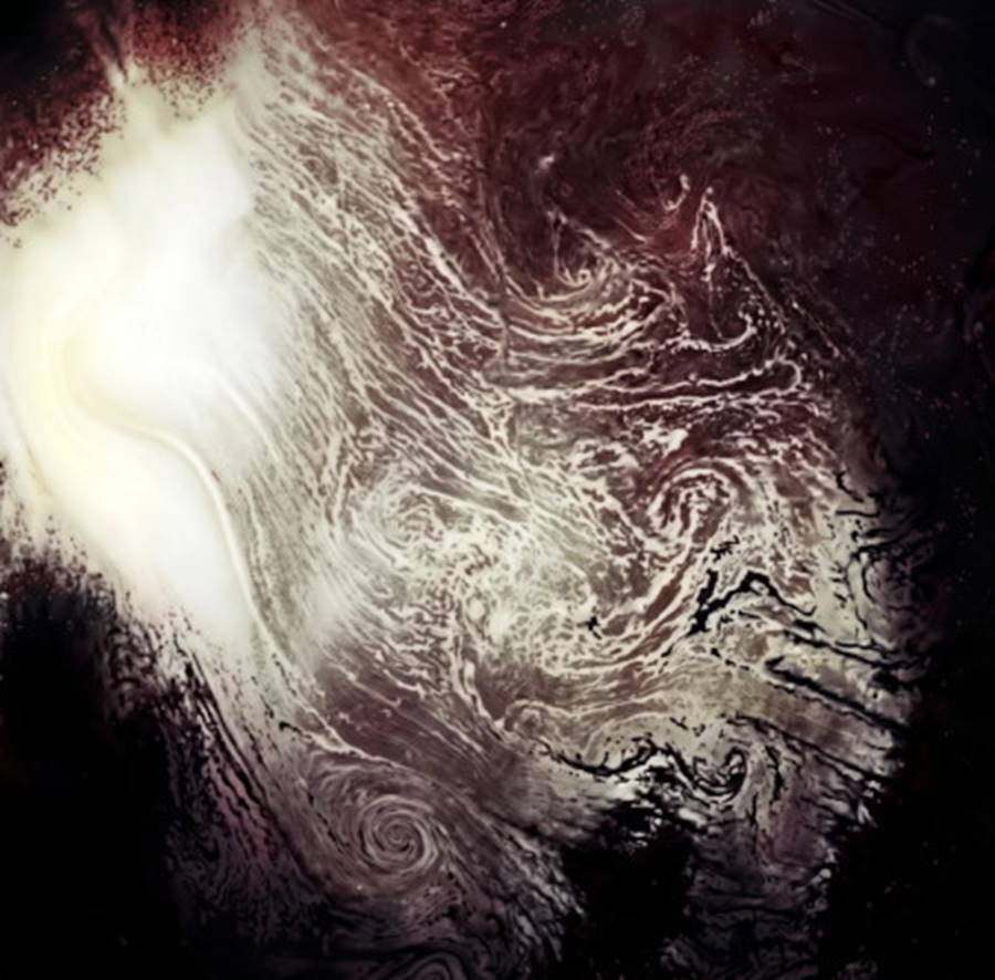
Fig. 8.9. Space shuttle view. Sunlight reflected off the Mediterranean reveals spiral eddies; their effects on climate are being monitored.
Date added: 2026-11-09; views: 4;