
Surface Currents and Gyres: The Physics of Oceanic Circulation
Surface Currents and Gyres. When the winds blow over the oceans they set the surface water in motion, driving the large-scale surface currents in nearly constant patterns. The density of water is about one thousand times greater than the density of air, and once in motion, the mass of the moving water is so great that its inertia keeps it flowing. The currents flow more in response to the average atmospheric circulation than to the daily weather and its short-term changes; however, the major currents do shift slightly in response to long-term seasonal changes in the winds. The currents are further modified by interactions that occur among the currents, zones of converging and diverging water, and landmasses. The major surface currents have been called the rivers of the sea; they have no banks to contain them, but they maintain their average course.
Because the friction coupling between the ocean water and the Earth's surface is small, the moving water is deflected by the Coriolis effect in the same way that moving air is deflected. But because water moves more slowly than air, it takes longer to move the water the same distance as air. During this longer time period, the Earth rotates farther out from under the water than from under the wind. Therefore, the slower-moving water is deflected to a greater degree than the overlying air. The surface water layer acted upon by the Coriolis effect is deflected to the right of the driving wind direction in the Northern Hemisphere and to the left in the Southern Hemisphere. In the open sea, the surface layer is deflected at a 45° angle from the wind direction, as shown in figure 8.1.
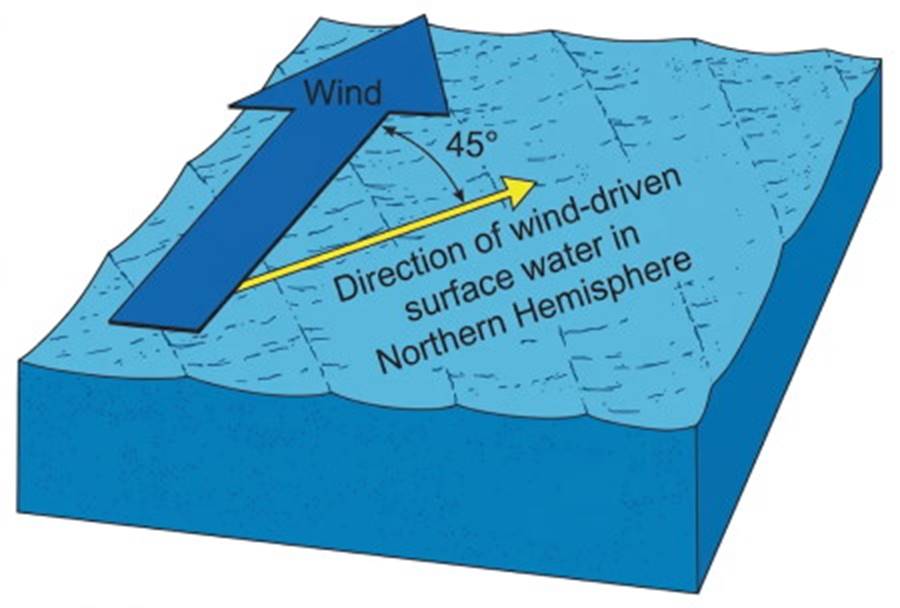
Fig. 8.1. A wind-driven surface current moves at an angle of 45° to the direction of the wind; this angle is to the right in the Northern Hemisphere and to the left in the Southern Hemisphere.
The combined effects of the wind on the surface, the deflection of the water, and the shape and distribution of the landmasses create the large-scale patterns of the wind-driven surface currents in each of the oceans. Refer to figure 8.2 as you read the description of surface currents in the world's major oceans. In the Northern Hemisphere the water under the westerlies moves 45° to the right of the westerlies, away from an ocean's western shore or boundary, and along the 40°–50°N latitudes until it reaches its eastern shore or boundary.
The water under the trade winds moves 45° to the right of the trades, away from an ocean's eastern boundary, and along the 10°–20° latitude until it reaches its western boundary. When Northern Hemisphere water moving with the trade winds accumulates at the land boundary on the west side of an ocean, the water flows north to the latitude of the westerlies and then eastward across the ocean. Water accumulating at the land boundary on the east side of a northern ocean flows south, toward the region from which the water moves westward under the trade winds.
In Southern Hemisphere oceans the east-west currents are deflected 45° to the left of the trade winds and the westerlies. Water accumulating on the eastern side of a Southern Hemisphere ocean moves north, and water on the western side of a southern ocean moves south. In each hemisphere this pattern produces continuous flow and a series of interconnecting surface currents moving in a circular path centered on 30° latitude. The rotation is clockwise in the Northern Hemisphere and counterclockwise in the Southern Hemisphere.
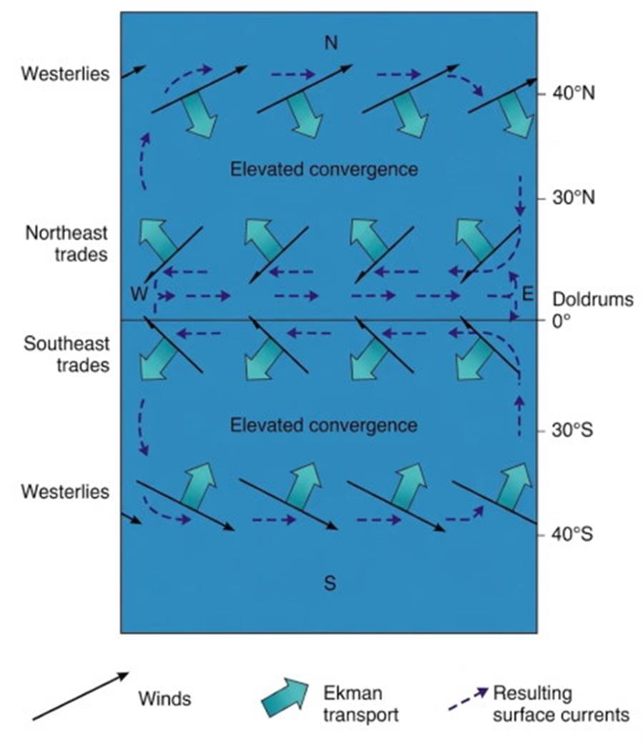
Fig. 8.2. Wind-driven transport and resulting surface currents in an ocean bounded by land to the east and to the west. The currents form large oceanic gyres that rotate clockwise in the Northern Hemisphere and counterclockwise in the Southern Hemisphere.
These circular-motion current systems are known as gyres. In the more southern latitudes there is no land between the Atlantic, Pacific, and Indian Oceans; here the surface currents, driven by the westerlies, continue around the Earth in a circumpolar flow around Antarctica.
The Ekman Spiral and Ekman Transport. Wind-driven surface water sets the water immediately below it in motion. But because of low friction coupling in the water, this next deeper layer moves more slowly than the surface layer and is deflected to the right (Northern Hemisphere) or left (Southern Hemisphere) of the surface layer direction. The same is true for the next layer down and the next.
The result is a spiral in which each deeper layer moves more slowly and with a greater angle of deflection than the layer above. This current spiral is called the Ekman spiral, after the physicist V. Walfrid Ekman, who developed its mathematical relationship. The spiral extends to a depth of approximately 100 to 150 m (330–500 ft), where the much-reduced current will be moving exactly opposite to the surface.
Over the depth of the spiral, the average flow of all the water set in motion by the wind, or the net flow (Ekman transport), moves 90° to the right or left of the surface wind, depending on the hemisphere in which the motion takes place (fig. 8.3). This relationship is in contrast to the surface water, which moves at an angle of 45° to the wind direction.
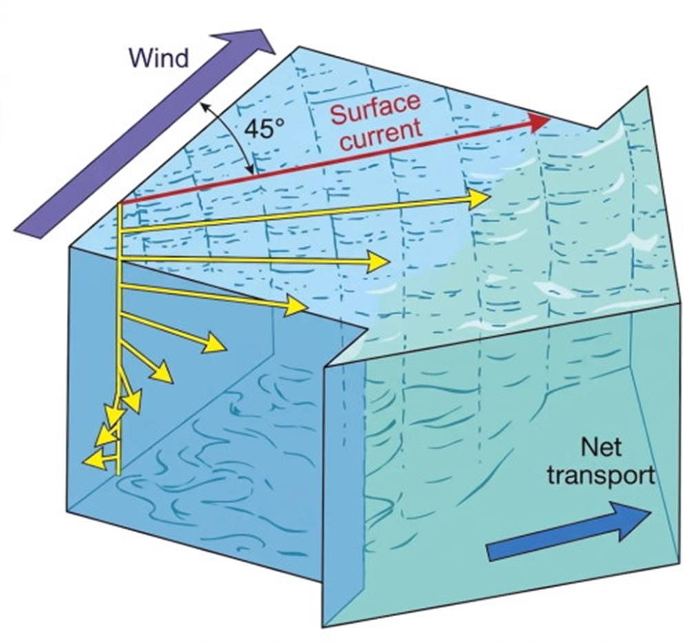
Fig. 8.3. Water is set in motion by the wind. The direction and speed of flow change with depth to form the Ekman spiral. This change with depth is a result of the Earth's rotation and the inability of water, due to low friction, to transmit a driving force downward with 100% efficiency. The net transport over the wind-driven column is 90° to the right of the wind in the Northern Hemisphere and 90° to the left in the Southern Hemisphere.
Geostrophic Flow in Oceanic Gyres. If Ekman transport is applied to oceans with east-west land boundaries, a portion of the wind-driven surface water is deflected toward the center of each of the large, circular, current gyres described above (fig. 8.2). A convergent lens of surface water is elevated more than 1 m (3 ft) above the equilibrium sea level and this lens, depresses the underlying denser water. The surface slope of the mound increases as water moves inward until the force of gravity driving the water downhill and away from the gyre center equals the Coriolis effect acting to deflect the moving water into the raised central mound.
At this balance point, geostrophic flow is said to exist, and no further deflection of the moving water occurs. Instead, the currents flow smoothly around the gyre parallel to its elevation contours. See figure 8.4 for a diagram of this process.
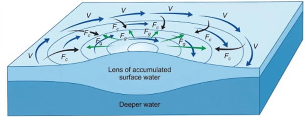
Fig. 8.4. Geostrophic flow (V) exists around a gyre when F꜀, the inward deflection force due to the Coriolis effect, is balanced by F_g, the outward, downslope gravitational force. The example is of a clockwise gyre in the Northern Hemisphere.
Using the subsurface water-density distribution to describe the extent of the depression of the deeper water, oceanographers are able to calculate the elevation and slope of the sea surface and so calculate the velocity, volume transport, and depth of the currents present in the geostrophic flow around the mound. The Sargasso Sea in the North Atlantic Ocean is the classic example of a gyre in geostrophic balance; it is discussed following the Atlantic currents in section 8.2.
Date added: 2026-11-09; views: 6;