
Oceanic Upwelling, Downwelling, and Global Circulation Oscillations
Mechanisms of Thermohaline and Wind-Driven Circulation. Downwelling water sinks until it reaches a level at which it is denser than the water above but less dense than the water below. At the surface, water moves horizontally into the region where sinking is occurring; this effect is known as a surface convergence. The dense water that has descended must displace water, producing an upwelling at some other location. At the surface, water moves away from the area of upwelling water, forming a surface divergence. This type of thermohaline upwelling and downwelling is discussed in section 6.4 of chapter 6.
When wind-driven surface currents collide or are forced against landmasses they also produce a surface convergence. When surface currents move away from each other or away from a landmass they produce a surface divergence. The resulting upwelling and downwelling zones are nearly permanent, reacting to seasonal changes in the Earth's surface winds.
Permanent Zones. Zones of convergence and divergence are shown in Fig. 8.10 and in Fig. 6.14. There are five major zones of convergence:
- The tropical convergence at the equator.
- The two subtropical convergences at approximately 30° to 40°N and S.
- The Arctic and Antarctic convergences at about 50°N and S.
Surface convergence zones are regions of downwelling. These areas are low in nutrients and biological productivity. There are three major divergence zones: the two tropical divergences and the Antarctic divergence. Upwelling associated with divergences delivers nutrients to the surface waters to supply the food chains that support the tropical tuna fisheries and the richly productive waters of Antarctica.
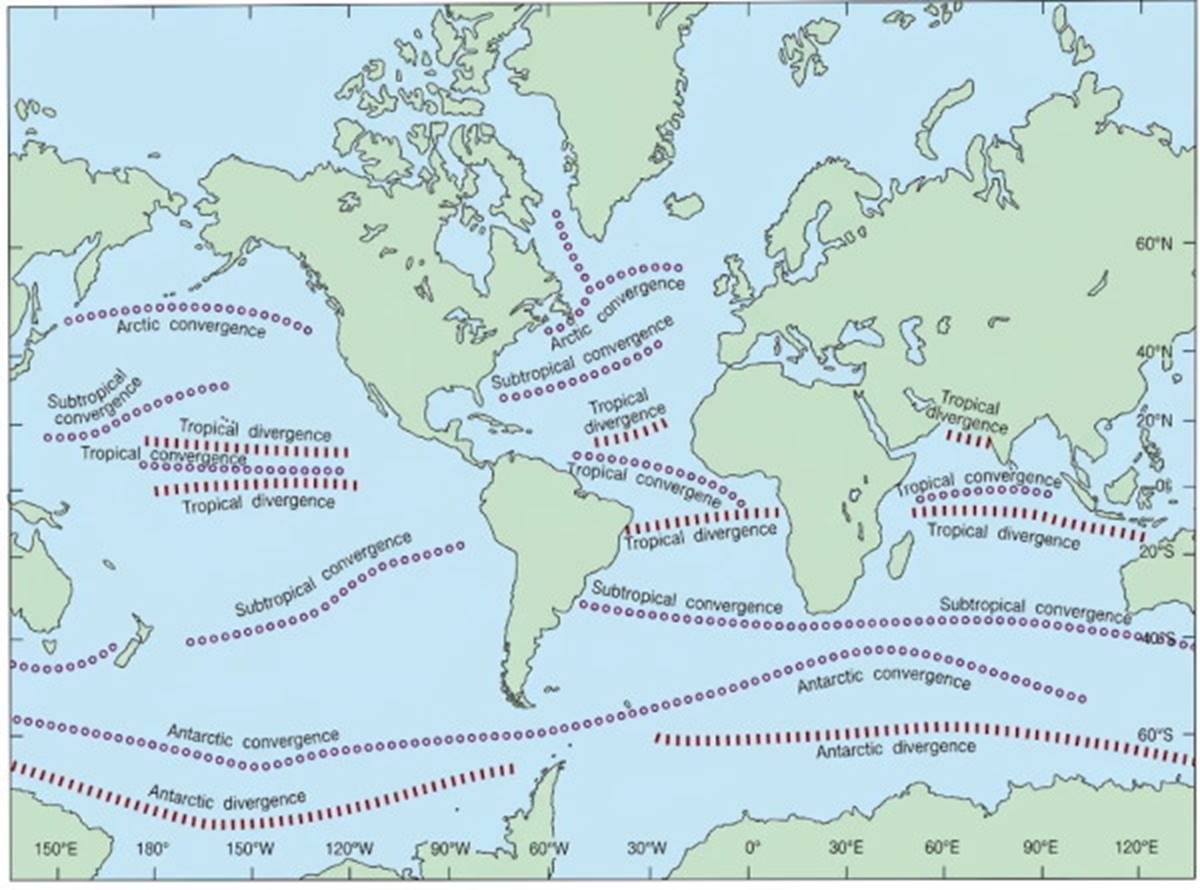
Fig. 8.10. The principal zones of open-ocean surface convergence and divergence associated with wind-driven and thermohaline circulation.
In coastal areas where trade winds move the surface waters away from the western side of continents, upwelling occurs nearly continuously throughout the year. For example, upwellings off the west coasts of Africa and South America are very productive and yield large fish catches.
Seasonal Zones. Off the west coast of North America, downwelling and upwelling occur on a seasonal basis as the Northern Hemisphere temperate wind pattern changes from southerly in winter to northerly in summer. The downwelling and upwelling occur because of the change in direction of Ekman transport (see Fig. 8.11). Remember that the wind-driven Ekman transport moves at an angle of 90° to the right or left of the wind direction, depending on the hemisphere.
Along this coast, the average wind blows from the north in the summer, and the net movement of the water is to the west, or 90° to the right of the wind. This action results in the offshore movement of the surface water and the upwelling of deeper water along the coast to replace it. The upwelling zone is evident from central California to Vancouver Island. In winter, the winds blow from the south; the wind-driven surface waters move to the east, onshore against the coast; and downwelling occurs (see Fig. 8.12 and refer to Fig. 7.15).
The summer upwelling pattern is what produces the band of cold coastal water at San Francisco that helps cause the frequent summer fogs (refer to chapter 4). Because of the lack of land at the mid-latitudes in the Southern Hemisphere, this type of seasonal upwelling is less common.
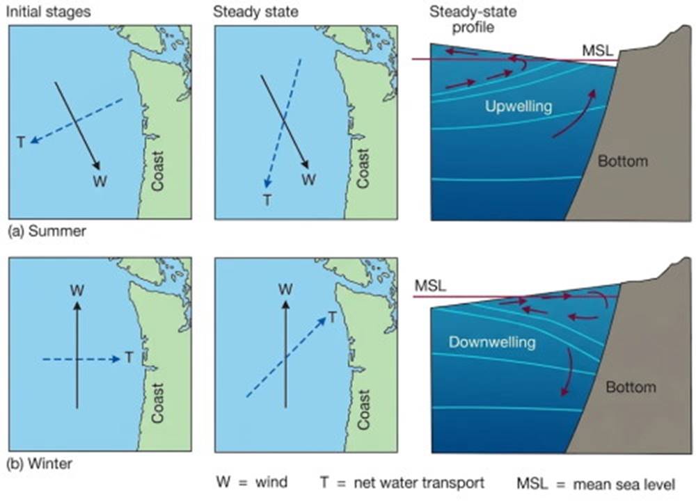
Fig. 8.11. Initially, the Ekman transport is 90° to the right of the wind along the northwest coast of North America. As water is transported (a) away from the shore in summer or (b) toward the shore in winter, a sea-surface slope is produced. This slope creates a gravitational force that alters the direction of the Ekman transport to produce a geostrophic balance and a new steady-state direction. From Sverdrup/Johnson/Fleming, The Oceans, © 1942, renewed 1970, p. 501. Adapted by permission of Prentice Hall, Inc., Upper Saddle River, New Jersey.
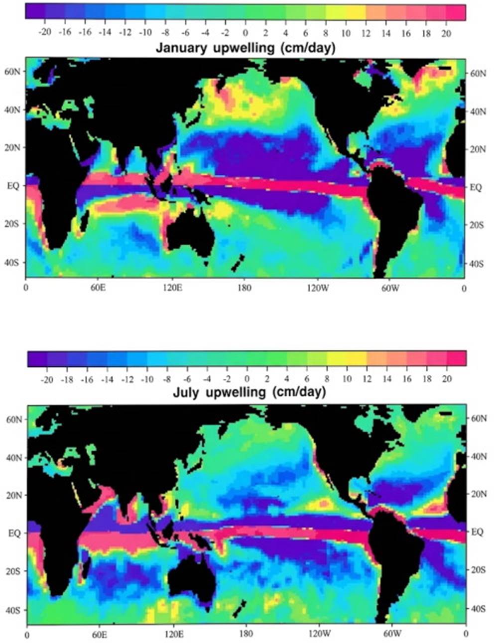
Fig. 8.12. Surface winds produce surface divergences and convergences that create areas of upwelling and downwelling. Average surface wind stress values were used to produce this model of global upwelling and downwelling for January (a) and July (b). Negative upwelling values indicate downwelling. Speed of vertical motion is given in centimeters per day.
Water Mass Mixing. Convergence and divergence of surface currents result not only in upwellings and downwellings but also in the mixing of water from different geographic areas. Waters carried by the surface currents converge, share properties due to mixing, and form new water mixtures with specific ranges of temperature and salinity, which then sink to their appropriate density levels. After sinking, the water moves horizontally, blending and sharing its properties with adjacent water, and eventually it rises to the surface at a new location.
This process is discussed as thermohaline circulation in the section on density-driven circulation in chapter 6. Thermohaline circulation and wind-driven surface currents are closely related. The connections are so close among formation of water mixtures, upwelling and downwelling, and convergence and divergence that it is difficult to assign a priority of importance to one process over another. Changes in these flows and events that might cause such changes are discussed in the next section.
Changing Circulation Patterns. Global Currents. The interchange of water between oceans redistributes heat, salt, and dissolved gases; use Fig. 8.13 to trace the surface and deep water flows of the world's oceans. Is it possible that some phenomenon could alter this water motion and trigger changes that would have major climatic consequences?
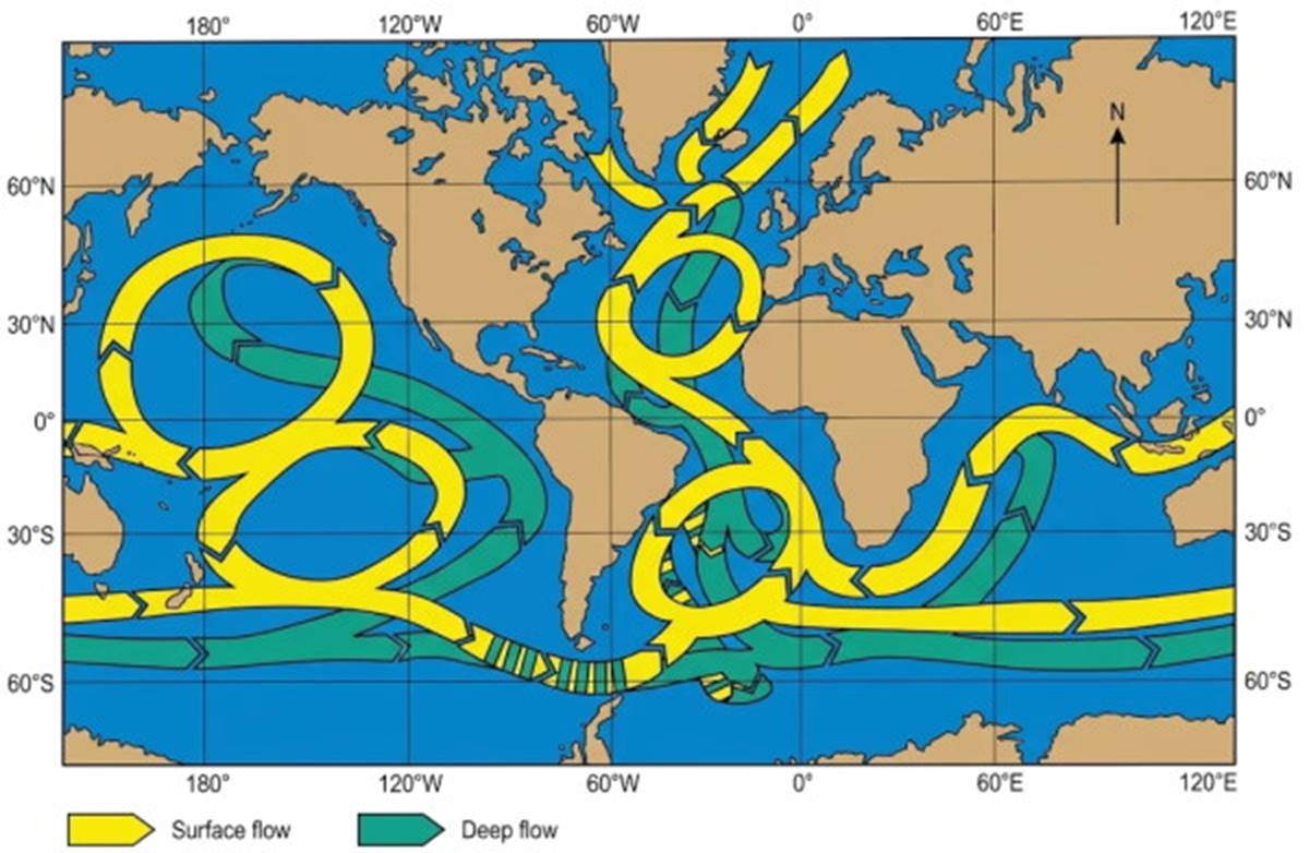
Fig. 8.13. The present flow of ocean water within and between oceans circulates at the surface (yellow arrows) and at depth (green arrows). Cold surface water sinks to the sea floor in the North Atlantic Ocean, then flows south to be further cooled by the Antarctic Bottom water formed in the Weddell Sea. This deep water moves eastward around Antarctica, feeding into the surface layer of the Indian Ocean and also into the deep basins of the Pacific Ocean. A return flow of surface water from the Pacific and Indian oceans flows north to replace the surface water in the North Atlantic Ocean.
Studies of fossil marine organisms found in cores of marine sediments show that the temperature of the North Atlantic Ocean during glacial and interglacial periods can be related to Milankovitch cycles. These cycles are associated with regular long-term changes in the Earth's orbit and the relation of the Earth's axis to the Sun, producing variations in the amount and distribution of solar radiation over the Earth's surface. Twenty-three thousand years ago, the Earth had its period of minimum solar radiation. About 6000 years later, the Earth endured its coldest ocean temperatures and its maximum land ice volumes. Notice the time lag between decreasing solar energy and Earth cooling. However, sediment-core analysis shows that the warming of the oceans to today's temperatures occurred rapidly with high solar radiation 12,000 years ago. The warming, like the cooling, is related to the Milankovitch cycles of Earth-Sun placement.
Water is a good absorber of solar radiation but ice is a poor absorber and a good reflector, so the land ice melted slowly as the oceans warmed rapidly. Eleven thousand years ago, the surface temperatures of the water in the North Atlantic and the air temperatures in northern Europe decreased suddenly; the sudden decrease was unrelated to the long-term solar cycles. The temperatures remained low for about 700 years in a mini ice age; large changes (20%) in atmospheric carbon dioxide gas trapped in ice cores of Greenland are associated with this period. These changes are interpreted to mean that large global atmospheric changes occurred and at the same time there was localized cooling of Europe and the North Atlantic. This could not have happened unless major changes occurred in the ocean circulation system that transports heat and carbon dioxide.
The required connections between global atmospheric changes and ocean circulation during the time of this mini ice age have led Wallace Broecker of Lamont Doherty Geophysical Observatory to think that something triggered a sudden shutdown of the circulation of the North Atlantic. Broecker suggests that some event prevented the transport of warm surface water northward and interfered with the formation of North Atlantic deep water and in so doing greatly reduced the deep water flowing south. Under such conditions worldwide oceanic circulation would change and the oceans' ability to transport and store carbon dioxide would be altered. A change in the carbon dioxide storage capacity of the oceans requires a corresponding change in atmospheric carbon dioxide levels.
Broecker has proposed that the trigger for such an episode was a sudden change in the location where meltwater from the receding North American ice sheet entered the Atlantic Ocean. Large quantities of cold, low-density, low-salinity water entering the oceans would significantly affect the salinity and density of the North Atlantic's surface waters. Geological studies support Broecker's ideas. We know that the majority of the meltwater from the early stages of the receding glaciers in North America converged on the Mississippi River system and drained into the Gulf of Mexico, not directly into the Atlantic.
But gradually, as the ice margin receded, meltwater was diverted through the Hudson River drainage system, into the Great Lakes and the St. Lawrence River valley, and then into the North Atlantic. The result was a diluting and cooling of the Atlantic surface water; it no longer supplied heat to the atmosphere that had warmed northern Europe. At the same time, the diluted surface water did not sink, and therefore, the production of North Atlantic deep water was slowed, preventing the northward migration of warm equatorial water and affecting the circulation in all oceans. This event ceased as rapidly as it had started. As the melting of the glaciers slowed, the influx of meltwater was reduced. Surface warming and evaporation increased surface water density, and the formation of North Atlantic deep water resumed. The thermohaline circulation of the North Atlantic began a rapid recovery.
North Pacific Oscillations. W. James Ingraham Jr., an oceanographer at NOAA's Seattle laboratory, has developed a North Pacific current model, or North Pacific Ocean Surface Current Simulation (OSCURS). When the model was used to map current patterns for North Pacific surface water between 1902 and 1997, it showed a north-south current oscillation associated with changes in atmospheric pressure and climate shifts. Cold and wet conditions are associated with a southerly current flow, and warm and dry conditions predominate with a northerly flow (see Fig. 8.14).
This evidence was compared with climate-sensitive tree-ring data from the western juniper tree that grows in eastern Oregon. These trees show wide rings during periods when currents moved to the north and narrow rings when currents moved to the south. Tree-ring data cover many more years than oceanographic and meteorological data, and from the tree rings it is calculated that there have been thirty-four north-south oscillations since the time of Columbus. The most common time period between fast and slow growth is seventeen years, with twenty-three- and twenty-six-year periods not uncommon. Tree-ring data and current oscillations agree.
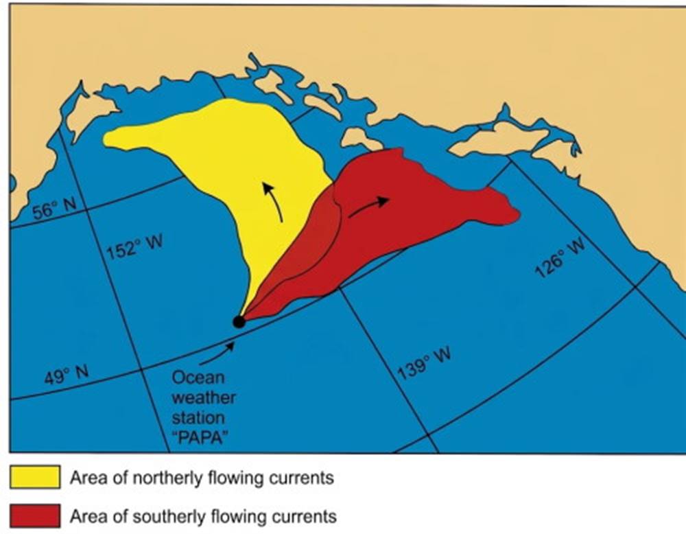
Fig. 8.14. North-south current shifts in the Northeast Pacific are associated with changes in atmospheric pressure, winds, precipitation, and water temperature. This phenomenon is known as the Pacific Decadal Oscillation, or PDO.
The climate pattern is presently warm and dry with a northerly current flow that has not changed since 1967. This is one of the longest periods without a reversal that has been found during the last 500 years. The wet conditions of winter 1998-99, if continued, may indicate a climate shift that will switch the currents to a southerly flow. These current shifts are associated with changes in atmospheric pressure, winds, precipitation, and water temperature; together they are known as the Pacific Decadal Oscillation, or PDO. Because the PDO affects coastal surface temperatures from California to Alaska, it is thought to affect the fish stocks of the area, especially the salmon. Commercial fishing will be discussed further in chapter 16.
North Atlantic Oscillations. A large pool of cold, low-salinity surface water appeared in the waters off Greenland, north of Iceland, in 1968. It was about 0.5‰ less salty and 1° and 2°C colder than usual. Within two years this cool pool had moved west into the Labrador Sea off eastern Canada; then it crossed the Atlantic and, in the mid-1970s, moved north into the Norwegian Sea. It had returned to its place of origin by the early 1980s. Follow the path of this pool of water in Fig. 8.15. During this period harsh winters plagued Europe, and the entire Northern Hemisphere had cooler-than-average temperatures for more than ten years.
Recent studies have further investigated the North Atlantic, seeking to improve and lengthen our ability to predict climate. The new analysis shows pools of warm and cool surface water that circle the North Atlantic; the pools seem to have life spans of four to ten years. Because of the alternation of climatic conditions this is referred to as the North Atlantic Oscillation (NAO). Investigators are finding pieces of the puzzle that are associated with NAO but have not yet found the trigger that controls the system. A counterclockwise wind circulation centered over Iceland and a high pressure clockwise circulation residing near the Azores is the usual situation.
If the air pressure differences between these two locations is large, then strong westerly winds supply Europe with heat from the North Atlantic Current. If the air pressure difference decreases, then weaker-than-normal westerlies drive less warm water into the Norwegian Current and less heat is delivered to Europe. The periods of 1950-71 and 1976-80 were recognized as prolonged cool periods for Europe. The winds may also drive cold, low-salinity water from the Arctic into the area where North Atlantic deep water is formed. The influx of this water may cause a small-scale reduction in the formation of North Atlantic deep water and an accompanying reduction of warm surface water moving northward.
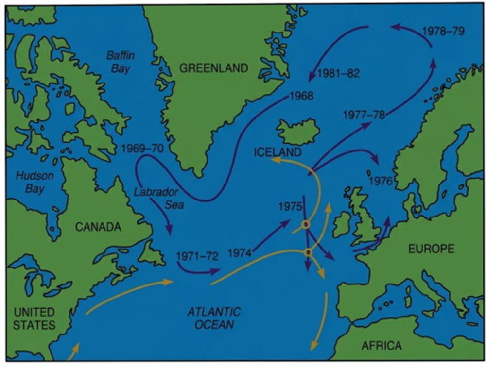
Fig. 8.15. Purple arrows follow the path of the North Atlantic cool pool. Orange arrows show warm-water flow from the Gulf Stream.
Natural cycles operate at a variety of time scales and magnitudes, and they interact and react in ways we do not yet fully comprehend. In the enormously complex series of interactions that oceanographers and meteorologists are observing they are beginning to identify the strands that unite the ocean-atmosphere and the world current systems. Eventually, longer-term predictions concerning the oceans and the atmosphere will become possible; how we use such information and whether it will benefit ocean resources are not yet clear.
Date added: 2026-11-09; views: 10;