
Wave Mechanics: Deep-Water Dynamics, Steepness, and Sea States
Deep-Water Wave Characteristics. "Deep water" has a precise meaning for the oceanographer studying waves. To be a deep-water wave, the wave must occur in water that is deeper than one-half the wave's length. Under this condition the orbits of the wave do not reach the sea floor. For example, a 15-m-long wave must occur in water that is deeper than 7.5 m in order to be considered a deep-water wave and to behave as the waves described next.
The wavelength (L) of deep-water waves is derived from the wave period (T), and, because wavelength (L) is a function of wave period (T), wave speed (C) is also derived from wave period (T). The oceanographer at sea determines the wave period (T) by direct measurement and calculates the wavelength (L) from its relationship with gravity and wave period. In deep water, the wavelength is equal to the Earth's acceleration due to gravity (g) divided by 2π times the square of the wave period (T). The value of Earth's gravity, g, is 9.81 m/s².
L = (g / 2π) T² or L = 1.56 m/s² T²
This deep-water wave equation, when combined with the general wave speed equation C = L/T, is used to determine wave speed (C) from either wavelength (L) only or wave period (T) only:
C = L/T = (g / 2π) T or C² = L²/T² = (g / 2π) L
C = 1.56 T or C² = 1.56 L
See appendix C for a more complete equation and the method used to calculate approximations of deep-water wavelength and celerity.
Storm Centers and Progressive Wind Waves. Most waves observed at sea are progressive wind waves. They are generated by the wind, are restored by gravity, and progress in a particular direction. These waves are formed in local storm centers or by the steady winds of the trade and westerly wind belts. In an active storm area covering thousands of square kilometers, the winds are not steady but turbulent, varying in strength and direction. Storm-area winds flow in a circular pattern about the low-pressure storm center, creating waves that move outward and away from the storm in all directions.
When a storm center moves across the sea surface in a direction following the waves, wave heights are increased because the winds supply energy for a longer time and over a longer distance. You may gain some idea of the size of storms and their direction of travel by viewing the cloud patterns in the satellite photographs that are presented in televised weather forecasts. In a storm area, the sea surface appears as a jumble and confusion of waves of all heights, lengths, and periods; there are no regular patterns. Capillary waves ride on the backs of small gravity waves, which in turn are superimposed on still higher and longer gravity waves.
This turmoil of mixed waves is called a "sea," and sailors use the expression "There is a sea building" to refer to the growth of these waves under storm conditions. When waves are being generated they are forced to increase in size and speed by the continuing input of energy; these are known as forced waves. Because of variations in the winds of the storm area, energy at different intensities is transferred to the sea surface at different pulse rates, resulting in waves with a variety of periods and heights. Remember, wave periods are a function of the generating force; the speed at which the wave moves may change, but its period remains the same.
Wave Dispersion and Sorting. When the waves move away from the storm's influence, they are no longer wind-driven forced waves but become free waves moving at speeds due to their periods and wavelengths. Waves with long periods and long wavelengths have a greater speed than waves with short periods and short wavelengths. The faster, longer waves gradually move through and ahead of the shorter, slower waves; this process is called sorting, or dispersion. Groups of these faster waves move as wave trains, or packets of similar waves with approximately the same period and speed.
Because of dispersion, the distribution of observed waves from any single storm changes with time. Near the storm center the waves are not yet sorted, while farther away the faster, longer-period waves are out ahead of the slower, shorter-period waves. This process is shown in Fig. 9.5. Away from the storm, the faster, longer-period waves appear as a regular pattern of crests and troughs moving across the sea surface. These uniform, free waves are called swell; they carry considerable energy, which they lose very slowly. The distribution of the waves from a given storm and the energy associated with particular wave periods change predictably with time, allowing the oceanographer to follow wave trains from a single storm over long distances. Groups of large, long-period waves created by storms between 40° and 50°S in the Pacific Ocean have been traced across the entire length of that ocean, until they die on the shores and beaches of Alaska.
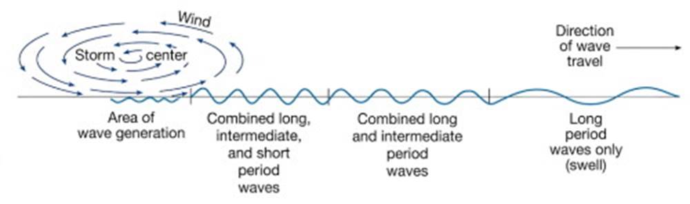
Fig. 9.5. Dispersion. The longer waves travel faster than the shorter waves. Waves are shown moving in only one direction in the diagram.
Group Speed. Consider again the waves formed by a stone thrown into the water; the wave group, or train, is seen as a ring of waves moving outward from the point of disturbance. Careful observation shows that waves constantly form on the inside of the train as it moves across the water. As each wave joins the train on the inside of the ring, a wave is lost from the leading edge, or outside, of the ring and the number of waves remains the same. The outside wave's energy is lost in advancing the wave form into undisturbed water. Therefore the speed of each individual wave (C) in the group is greater than the speed of the leading edge of the wave train, and the wave train moves outward at a speed one-half that of the individual waves.
This speed is known as the group speed, the speed at which wave energy is transported away from its source under deep-water conditions:
- group speed = ½ wave speed = speed of energy transport; or V = C / 2.
Wave Interaction and Interference. Waves that escape a storm and are no longer receiving energy from the storm winds tend to flatten out slightly, and their crests become more rounded. These waves moving across the ocean surface as swell are likely to meet other trains of swell moving out and away from other storm centers. When the two wave trains meet, they pass through each other and continue on. Wave trains may intersect at any angle, and many possible interference patterns may result. If the two wave trains intersect each other sharply, as at a right angle, then a checkerboard pattern is formed (Fig. 9.6).
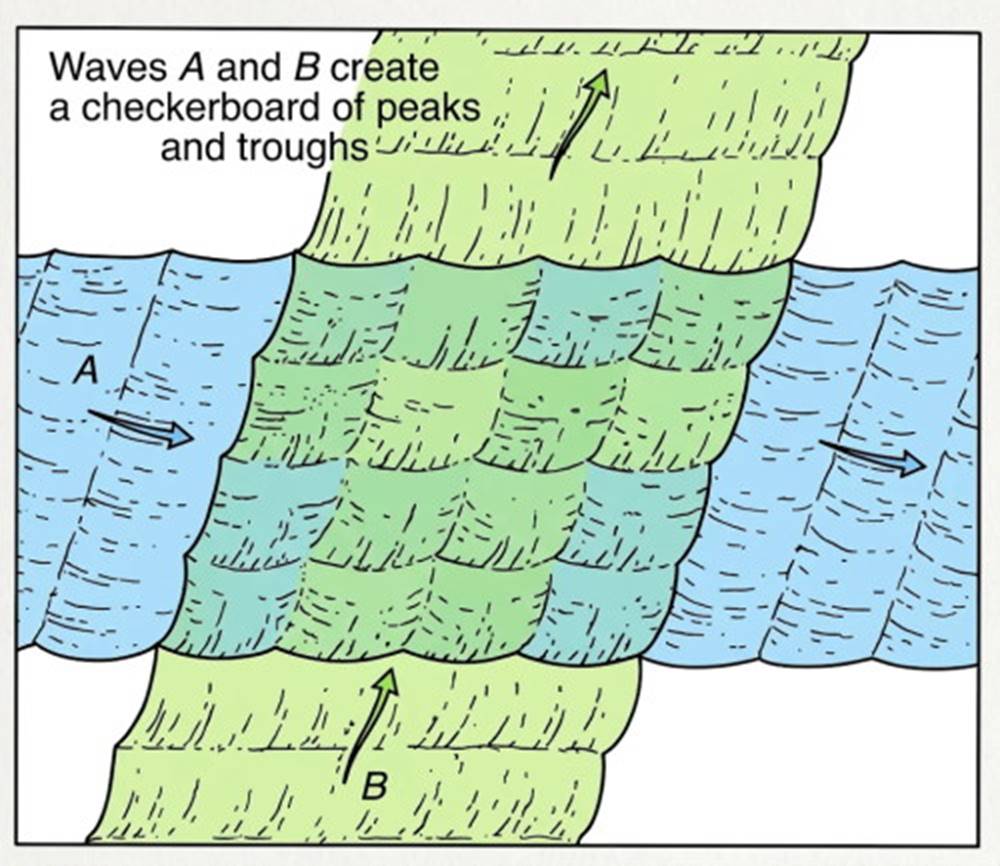
Fig. 9.6. Waves meeting at right angles create a checkerboard pattern.
If the waves have similar lengths and heights and approach from opposite directions (Fig. 9.7a), and if the crests of one wave train coincide with the crests of another train, the wave trains reinforce each other by constructive interference (Fig. 9.7b). If the crests of a wave train coincide with the troughs of another wave train, the waves are canceled through destructive interference (Fig. 9.7c). In this way two or more similar wave trains, traveling in the same or opposite direction and passing through each other, can phase together constructively and suddenly develop large-amplitude waves unrelated to local storms. If these waves become too high, they may break, lose some of their energy, and create new, smaller waves. If such high waves overtake a vessel, they can cause severe damage.
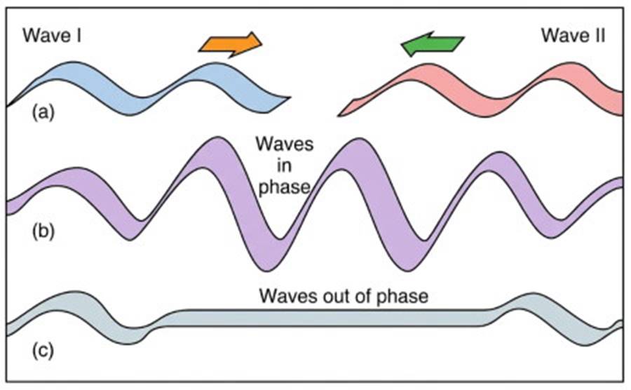
Fig. 9.7. Constructive and destructive interference between similar wave series. (a) Waves approach each other. (b) If the crests of the approaching waves coincide, the height of the combined waves increases, and the waves are in phase. (c) If the crests of one wave and the troughs of the other wave coincide, the waves cancel, and the waves are out of phase.
Factors Influencing Wave Height. The height of actual waves is controlled by the interaction of several factors. The three most important factors are (1) wind speed (how fast the wind is blowing), (2) wind duration (how long the wind blows), and (3) fetch (the distance over water that the wind blows in a single direction). The wave height may be limited by any one of these factors. If the wind speed is very low, large waves are not produced, no matter how long the wind blows over an unlimited fetch. If the wind speed is great, but it blows for only a few minutes, no high waves are produced despite unlimited wind strength and fetch.
Also, if very strong winds blow for a long period over a very short fetch, no high waves form. When no single one of these three factors is limiting, spectacular wind waves are formed at sea. Table 9.1 lists the maximum and significant wave heights possible for certain average wind speeds when fetch and wind duration are not limiting. The significant wave height is defined as the average wave height of the highest one-third of the waves in a long record of measured wave heights. For example, if a storm wave record of 1200 successive waves is made and the individual wave heights are arranged in order of height, the average height of the 400 highest waves defines the significant wave height. Significant wave heights are forecast from wind data and the maximum wave heights are related to the significant wave heights by calculation.
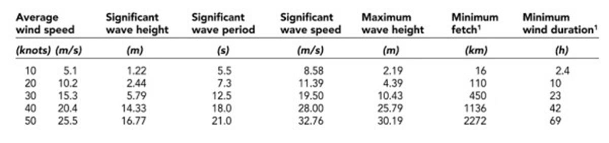
Table 9.1. The Relationship between Wind Speed and Wave Height. Minimum fetch and minimum wind duration are distances and times required when wind speed is the only limiting factor in wave development.
The area of the ocean in the vicinity of 40° to 50°S latitude is ideal for the production of high waves. Here, in an area noted for high-intensity storms and strong winds of long duration (what sailors have called the "roaring forties and furious fifties"), there are no landmasses to interfere and limit the fetch length. The westerly winds blow almost continuously around the Earth, adding energy to the sea surface for long periods of time and over great distances, resulting in waves that move in the same direction as the wind. Although this area is ideal for the production of high waves, such waves can occur anywhere in the open sea, given the proper storm conditions.
A typical maximum fetch for a local storm over the ocean is approximately 920 km (500 nmi). Because storm winds circulate around a low-pressure disturbance, the winds continue to follow the waves on the side of the storm, along which wave direction is the same as the storm direction. This increases both the fetch and the duration of time over which the wind adds energy to the waves. If the waves move fast enough, their speeds exceed the speed of the moving storm center; the waves escape the wind, become free waves, and do not grow larger. Waves 10 to 15 m (33–49 ft) high are not uncommon under severe storm conditions; such waves are typically between 100 and 200 m (330–660 ft) long.
This length is about the same as the length of some modern ships, and a vessel of this length encounters hazardous sailing conditions, because the ship may become suspended between the crests of two waves and break its back. Giant waves over 30.5 m (or 100 ft) high are rare. In 1933 the USS Ramapo, a Navy tanker en route from Manila to San Diego, encountered a severe storm, or typhoon. As the ship was running downwind to ease the ride, the Ramapo was overtaken by waves that, as measured against the ship's superstructure by the officer on watch, were 112 ft (34.2 m) high. The period of the waves was measured at 14.8 seconds; the wave speed was calculated at 27 m (90 ft) per second, and the wavelength at 329 m (1100 ft). Other storm waves in this size category have been reported, but none have been as well documented. It is also probable that ships confronted with such waves do not always survive to report the incidents.
Episodic Waves and Rogue Waves. Large waves, or episodic waves, can suddenly appear unrelated to local sea conditions. An episodic wave is an abnormally high wave that occurs because of a combination of intersecting wave trains, changing depths, and currents. We do not know a great deal about these waves, as they do not exist for long and they can do swamp ships, often eliminating any witnesses. They occur most frequently near the edge of the continental shelf, in water about 200 m (660 ft) deep, and in certain geographic areas with particular prevailing wind, wave, and current patterns.
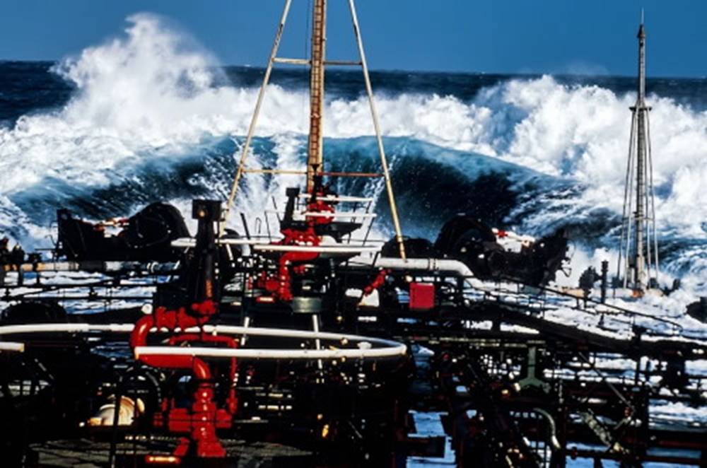
Fig. 9.8. A giant wave breaking over the bow of the ESSO Nederland southbound in the Agulhas Current. The bow of this supertanker is about 25 meters (80 feet) above the water.
The area where the Agulhas Current sweeps down the east coast of South Africa and meets the storm waves arising in the Southern Ocean is noted for such waves. Storm waves from more than one storm may combine and run into the current and against the continental shelf, producing occasional episodic waves. This area is also one of the world's busiest sea routes, as supertankers carrying oil from the Middle East ride the Agulhas Current on their trip southward to round the Cape of Good Hope en route to Europe and America.
The situation is an invitation to trouble, and tankers have been damaged and lost in this area (Fig. 9.8). In the North Atlantic, strong northeasterly gales send large storm waves into the edge of the northward-moving Gulf Stream near the border of the continental shelf, resulting in the formation of large waves. The shallow North Sea also seems to provide suitable conditions for extremely high episodic waves during its severe winter storms.
Researchers studying these waves describe them as having a height equal to a seven- or eight-story building (20–30 m, or 70–100 ft) and moving at a speed of 50 knots, with a wavelength approaching a half-mile (0.9 km). If such a wave topples onto a vessel that has dropped its bow into the preceding trough, there is no escape from the thousands of tons of water crashing on the deck. In the North Sea, maximum wave height for an episodic wave is calculated as 33.8 m (111 ft), but 22.9 m (75 ft) is the highest that has been observed. In the Agulhas Current area, researchers searched the storm records for a 20 year period and calculated a possible maximum wave height of about 57.9 m (190 ft).
There are many disappearances of vessels for which episodic waves are now suspected of being the chief cause. It seems that many of the casualties are tankers or bulk carriers of ore, grain, and the like. These vessels are susceptible not only because so many are at sea at any one time but also because of their design. Bulk carriers comprise a bow section and an aft (or rear) section that includes the engine and the crew accommodations. These sections are separated by a series of flat-bottomed boxes, or storage tanks, which make up the majority of the vessel's length. Because these vessels are about 300 m (1000 ft) long, they are subject to great wrenching forces if a large portion of the hull is left unsupported or is only partially supported while suspended between wave crests. More-traditional and smaller hull forms are stronger, ride more easily, and are less likely to be destroyed by these severe waves.
Wave Energy Distribution. A wave's energy is present as potential energy, due to the change in elevation of the water surface, and as kinetic energy, due to the motion of the water particles in their orbits. The higher the wave, the larger the diameter of the water particle orbit and the greater the speed of the orbiting particle, therefore the greater the kinetic and potential energy. The energy in a deep-water wave is nearly equally divided between kinetic and potential energy. Wave energy is averaged over one wavelength per unit width (one meter) of crest from sea surface to a depth of L/2 and is related to the square of the wave height. This relationship is demonstrated in Fig. 9.9.
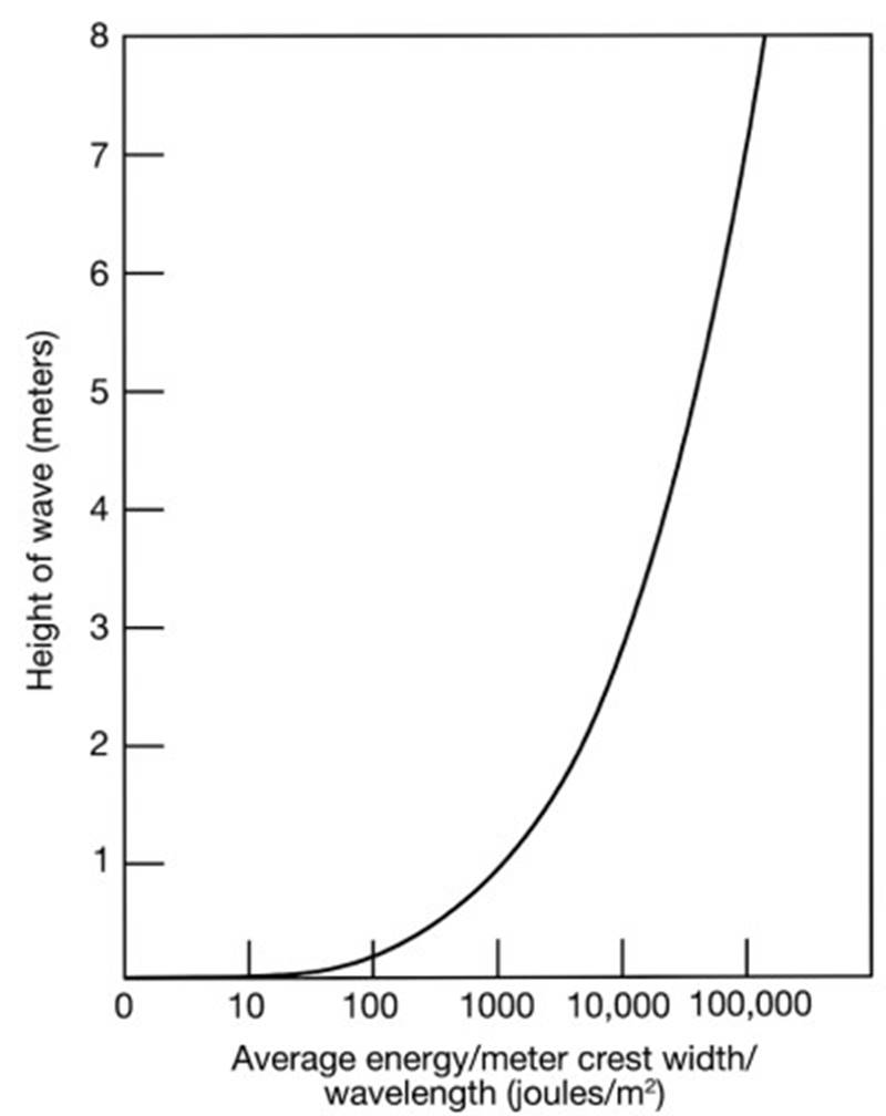
Fig. 9.9. Wave energy increases rapidly with the square of the wave height. Average wave energy is calculated per unit width of crest and averaged over the wavelength (L) and the depth (L/2).
Wave Steepness and Breaking. There is a maximum possible height for any given wavelength. This maximum value is determined by the ratio of the wave's height to the wave's length, and it is the measure of the steepness of the wave: Steepness = height / length or S = H / L.
If the ratio of the height to the length exceeds 1:7, the wave becomes too steep and the wave breaks. For example, if the wavelength is 70 m (230 ft), the wave will break when the wave height reaches 10 m (33 ft). The angle formed at the wave crest approaches 120°, and the wave becomes unstable. Under this condition the wave cannot maintain its shape; it collapses and breaks. See Fig. 9.10.
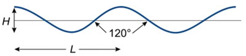
Fig. 9.10. Wave steepness. When H/L approaches 1:7, the wave's crest angle approaches 120° and the wave breaks.
Small unstable, breaking waves are quite common. When wind speeds reach 8–9 m/s (16–18 knots), waves known as whitecaps can be observed. These waves have short wavelengths (about 1 m), and the wind increases their height rapidly. As each reaches the critical steepness and crest angle, it breaks and is replaced by another wave produced by the rising wind.
Long waves at sea usually have a height well below their maximum value. There is rarely sufficient wind energy to force them to their maximum height. If a long wave does attain maximum height and breaks in deep water, tons of water are sent crashing to the surface. The energy of the wave is lost in turbulence and in the production of smaller waves. Rather than breaking, under such conditions it is more likely that the top of a large wave will be torn off by the wind and cascade down the wave face.
This action does not completely destroy the wave and is not considered to be the true collapse, or breaking, of such a wave. In addition, waves break and dissipate if intersecting wave trains pass through each other in proper phase to form a combined wave with sufficient height to exceed the critical steepness. Waves sometimes run into a strong opposing current, forcing the waves to slow down. Remember that the speed of all waves equals the wavelength divided by the period (C = L/T) and that a wave's period does not change. If the speed of a wave is reduced by an opposing current, its wavelength must shorten.
In such a case, the wave's energy is confined to a shorter-length wave, so the wave increases in height to satisfy the height-energy relationship. If the increase in height exceeds the maximum allowable height-to-length ratio for the shorter wavelength, the wave breaks. Crossing a sandbar into a harbor or river mouth during an outgoing or falling tide is dangerous because the waves moving over the bar and against the tidal current steepen and break. Entering a harbor or river should be done at the change of the tide or on the rising tide, when the tidal current moves with the waves, stretching their wavelengths and decreasing their heights.
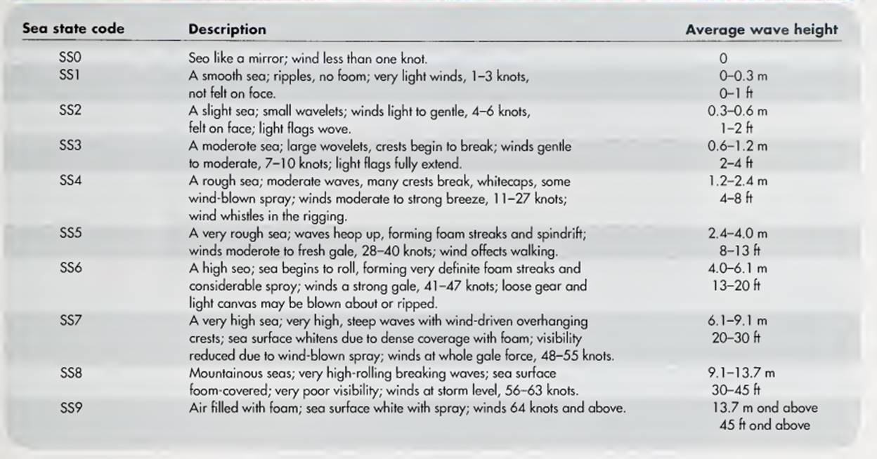
Historical Development of the Sea State Code. In 1806, Admiral Sir Francis Beaufort of the British navy adapted a wind-estimation system from land to sea use. On land, the clues to wind speed included smoke drift, the rustle of leaves, the flapping of flags, slates blowing from roofs, and uprooting of trees. Admiral Beaufort related observations of the sea-surface state to wind speed and designed a 0–12 (calm to hurricane) wind scale with typical wave descriptions for each level of wind speed. This Beaufort Scale was adopted by the U.S. Navy in 1838, and the scale was extended from 0 to 17.
Date added: 2026-11-09; views: 7;