
Seismic Sea Waves: Tsunami Origins, Behavior, and Historical Impact
Tsunami Generation and Terminology. Sudden movements of the Earth's crust may produce seismic sea waves, or tsunamis. These waves are often incorrectly called tidal waves. Because a seismic sea wave has nothing to do with tides, oceanographers have adopted the Japanese word tsunami, meaning harbor wave, to replace the misleading term tidal wave. Tsunami is a synonym for seismic sea wave.
If a large area, maybe several hundred square kilometers, of the Earth's crust below the sea surface is suddenly displaced, it may cause a sudden rise or fall in the overlying sea surface. In the case of a rise, gravity causes the suddenly elevated water to return to the equilibrium surface level; if a depression is produced, gravity causes the surrounding water to flow into it. Both cases result in the production of waves with extremely long wavelengths (100–200 km, or 60–120 mi) and long periods as well (10–20 minutes). The average depth of the oceans is about 4000 m (4 km, or 13,000 ft); this depth is less than one-twentieth the wavelength of these waves, so tsunamis are shallow-water waves.
These seismic waves radiate from the point of the seismic disturbance at a speed determined by the ocean's depth (C = √(gD)) and move across the oceans at about 200 m/s (400 mph). Because they are shallow-water waves, tsunamis may be refracted, diffracted, or reflected in mid-ocean by changes in seafloor topography and by the presence of mid-ocean islands.
Wave Characteristics in the Open Ocean and Nearshore. When a tsunami leaves its point of origin, it may have a height of 1 to 2 m (3–6 ft), but this height is distributed over its many-kilometer wavelength. It is not easily seen or felt when superimposed on the other distortions of the sea's surface, and a vessel in the open ocean is in little or no danger if a tsunami passes. The danger occurs only if the vessel has the misfortune to be directly above the area of the original seismic disturbance.
The energy of a tsunami is distributed from the ocean surface to the ocean floor and over the length of the wave. When the path of the wave is blocked by a coast or an island, the wave behaves like any other shallow-water wave; it slows (to approximately 80 km [50 mi] per hour), its wavelength decreases, and its energy is compressed into a smaller water volume as the depth rapidly decreases. This sudden confinement of energy causes the wave height to build rapidly, and the loss of energy is equally rapid when the wave breaks. A tremendous surge of moving water races up over the land, flooding the coast for a period that lasts five to ten minutes before the water flows seaward, exposing the nearshore sea floor.
The surge destroys buildings and docks; large ships can be left far up on the shore. In bays and inlets the rising and falling of the water may not be as destructive as the extreme currents at the entrance of a bay or an inlet, where large volumes of water oscillate in and out, producing dangerous and destructive current surges. If these oscillating flows occur at the natural oscillation period of the bay, large changes in water level are created (see section 9.11).
Trough and Crest Arrival Dynamics. The leading edge of the tsunami wave group may be either a crest or a trough. If the initial crustal disturbance is an upward motion, a crest arrives first; if the crustal motion is downward, a trough precedes the crest. If a trough arrives at the shore first, the water level drops by as much as 3 to 4 m (10–13 ft) within two to three minutes.
People who follow the receding water to inspect exposed sea life may drown, for in another four to five minutes the water will rise 6 to 8 m (20–26 ft) and they will not be able to outrun the wall of advancing water. In still another four to five minutes a trough with a water-level drop of 6 to 8 m (20–26 ft) will arrive, and the water flowing away from the beach will carry any debris out to sea. Tsunamis are most likely to occur in ocean basins that are tectonically active. The Pacific Ocean, ringed by crustal faults and volcanic activity, is the birthplace of most tsunamis. They also appear in the Caribbean Sea, which is bounded by an active island arc system, and in the Mediterranean Sea.
Historical Tsunami Events and Impacts. The spectacular havoc and destruction caused by these waves is well recorded in scientific and historical archives.
Krakatoa Eruption (1883). In August 1883 the Indonesian Island of Krakatoa erupted and was nearly destroyed in a gigantic steam explosion that hurled several cubic miles of material into the air. A series of tsunamis followed; these waves had unusually long periods of one to two hours. The town of Merak, 33 mi (53 km) away and on another island, was inundated by waves over 30.5 m (100 ft) high, and a large ship was carried nearly 3 km (2 mi) inland and left stranded 9.2 m (30 ft) above sea level.
More than 35,000 people died as a result of these enormous waves, and as the waves moved across the oceans, water level recorders were affected as far away as Cape Horn (12,500 km, or 7800 mi) and Panama (18,200 km, or 11,400 mi). The waves were traveling with a speed calculated at about 200 m/s, or 400 mi/h.
Aleutian Trench and Hawaii (1946–1964). On April 1, 1946, a crustal disturbance in the area of the Aleutian Trench off Alaska produced a series of tsunamis. These waves heavily damaged Hilo, Hawaii, killing more than 150 people. Not only the portion of the island facing the oncoming waves was damaged; the waves bent around the island by refraction and were diffracted when passing between islands, producing high waves that struck the sheltered side of the island.
The tsunami waves from the 1946 earthquake were highest near their source in the Aleutian Islands, where they destroyed a concrete lighthouse 10 m (33 ft) above sea level at Scotch Cap and killed the crew. A radio mast mounted 33 m (108 ft) above sea level in the same area was also destroyed. In 1957, Hawaii was hit again, with waves higher than the 1946 series; but no lives were lost because early warnings alerted people to evacuate (fig. 9.22). In 1964, the Alaska earthquake that severely damaged Anchorage and Alaskan coastal towns produced tsunamis that selectively hit areas on the west coast of Vancouver Island and the northern coast of California.
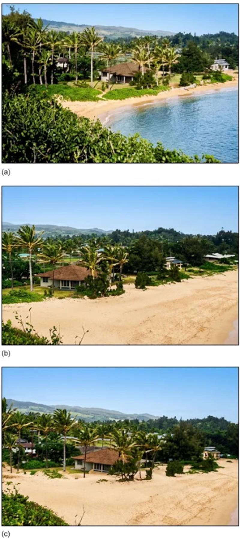
Fig. 9.22. Sequential photos of the major wave of a tsunami at Laie Point, Oahu, Hawaii, from an earthquake in the Aleutian Islands, March 9, 1957. The highest wave in Hawaii was 3.6 meters (11.8 feet) above sea level.
Nicaragua Earthquake (1992). On September 1, 1992, a 7.0-magnitude earthquake occurred 100 km (60 mi) off the Nicaraguan coast. The tsunami produced by this earthquake killed 170 people, injured 500, and destroyed 1500 homes. Eyewitnesses recall a single large wave, preceded by a trough that lowered the harbor depth by 7 m (23 ft). In this case the maximum run-up was 10 m (33 ft); run-ups of 2 to 6 m (7–19 ft) were more common. This event was triggered by an earthquake in a previously stationary section of a fault region associated with the Cocos Plate where it is being subducted under the Caribbean Plate.
Flores Island, Indonesia (1992). On December 12, 1992, an earthquake of magnitude 7.5 struck Flores Island in the Sunda and Banda island arc systems. The quake epicenter was only 50 km (30 mi) northwest of the town of Maumere, and five minutes after the quake, the first of a series of tsunamis struck the town. The earthquake and the tsunamis caused 2080 reported deaths and 2144 injuries. Average water run-up on the shore was 5 m (16 ft), with a maximum of 19.8 m (65 ft) at the northeast corner of the island.
Okushiri Island, Japan (1993). After ten o'clock at night on July 12, 1993, a 7.8-magnitude earthquake occurred in the Sea of Japan at the boundary of the Eurasian and North American plates and very close to Okushiri Island off the southwest coast of Hokkaido. Six minutes after the earthquake began, a tsunami swept over a 5 m (16 ft) seawall, destroyed buildings, and ruptured propane tanks that set fire to the town of Aonae at the southern end of Okushiri Island. In this case the longest wave run-up was 30 m (100 ft), with more typical values at 10 to 15 m (33–50 ft). One hundred eighty-five people died, and the property loss was estimated at $600 million (fig. 9.23).
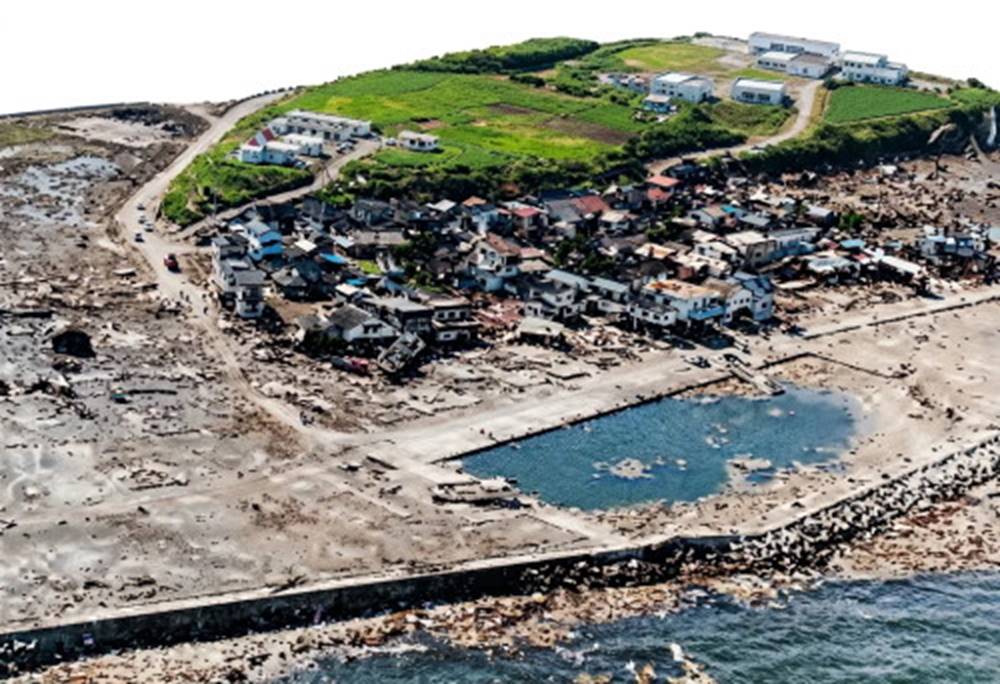
Fig. 9.23. Aonae at the southern tip of Okushiri Island in the Sea of Japan after the tsunami and fire of 1993. The area on the left extending to the tip of the island was leveled despite the protecting sea wall. Debris left in the streets by the surging water prevented fire control equipment from reaching the burning buildings.
Papua New Guinea (1998). A massive tsunami struck the northwest coast of Papua, New Guinea on July 17, 1998. The 7 to 15 m (22–50 ft) high tsunami swept across the barrier beach parallel to Sissano Lagoon, destroying four fishing villages (fig. 9.24). Three waves swept debris and bodies into the lagoon and the mangrove trees beyond.
More than 2,000 persons were killed or reported missing. The tsunami was probably triggered by a close-to-shore underwater earthquake (magnitude 7 on the Richter scale) that caused a 2 meter (6 ft) vertical drop along a 40 km (24 mi) fault in the sea floor followed by an underwater landslide. Although the island experienced tremors thirty minutes before the arrival of the first wave, there was no recognition of their significance in the shore area. See Tsunami Warning Systems Box in this chapter.
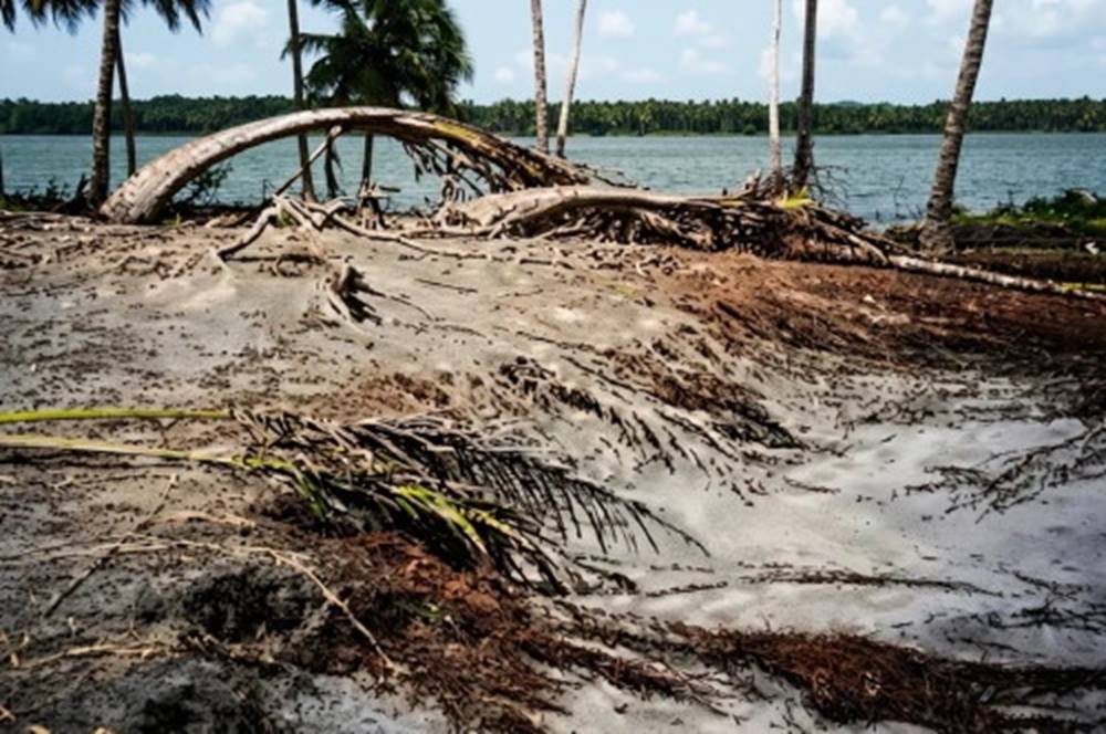
Fig. 9.24. The tsunami that struck the northwest coast of Papua, New Guinea, 17 July, 1998, destroyed a chain of villages along 30 km (18 mi) of beach bordering Sissano Lagoon. Buildings, trees, and people were swept away by three waves 7–15 m (22–50 ft) high. The eroded beach and the shattered palms were all that was left of many communities.
Date added: 2026-11-09; views: 7;