
Beach Dynamics: Morphology, Coastal Sediment Transport, and Circulation
Beach Morphology and Sediment Composition. Beaches are described in terms of (1) shape and structure, (2) composition of beach materials, (3) size of beach materials, and (4) color. In the first category, beaches are described as wide or narrow, steep or flat, and long or discontinuous (pocket beaches). A beach area that extends outward from the main beach and turns and parallels the shore is called a spit (refer to fig. 11.12). Spits frequently change their shape in response to waves, currents, and storms. In a wave-protected environment, a spit may extend out at an angle from the shore to an offshore island. If this spit builds until it connects the rock or island to the shore, it forms what is called a tombolo. A spit extending offshore in a wide sweeping arc bending in the direction of the prevailing current is called a hook. The sediment moves around the end of a hook and is deposited in the quiet water behind the point, often producing a broad point on its end. See figure 11.18 for an example of a tombolo and figure 12.4 for an example of a hook.
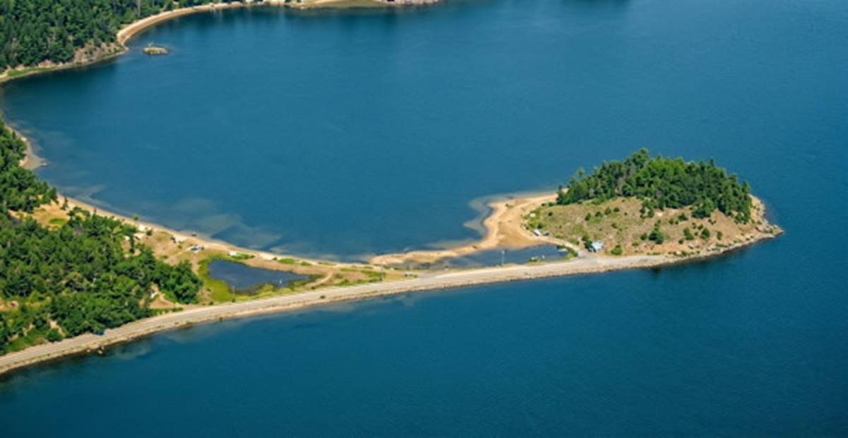
Fig. 11.18. A spit connected to an offshore island forms a tombolo. Tombolos are often formed by converging currents from nearshore eddies; the currents transport sediment toward the tombolo from both sides.
Beach Materials and Particle Size. Materials that form beaches include shell, coral, rock particles, and lava. Shingles are flat, circular, smooth stones formed from layered rock when the beach slope, wave action, and stone size combine to slide the stones back and forth with the water movement. When stones roll rather than slide, round stones or cobbles are formed. The terms sand, mud, pebble, cobble, and boulder describe the size of beach particles (refer to chapter 3).
Both the composition of the beach material and its size are related to the source of the material and the forces acting on the beach. Land materials are brought to the coast by the rivers or are derived from the local cliffs by wave erosion. The sands of many beaches are the ground-up, eroded products of land materials rich in minerals such as quartz and feldspar. Small particles such as sand, mud, and clay are easily transported and redistributed by waves and currents; larger rocks are usually found in the area close to their source, because they are too large to be moved any distance. The finer particles are carried away by the currents, and the larger rocks are left scattered on the beach. The Moeraki Boulders (fig. 11.19), found along the eastern coast of New Zealand's South Island, are the world's largest examples of calcite-type mud balls. Some are 2 m (6.5 ft) in diameter and are eroded from the beach cliffs. In general, a beach littered with large rocks is an eroded beach, and the remaining large rocks are called lag deposits. If the lag deposits accumulate in sufficient quantity to protect a beach from further wave and water erosion, the beach is known as an armored beach (fig. 11.20).
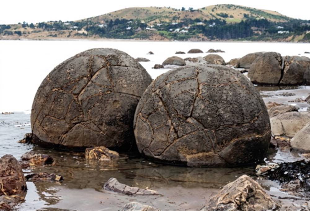
Fig. 11.19. Mud balls are washed out of the cliffs of many beaches. These "Moeraki boulders," hardened by the deposition of calcite minerals, are among the world's largest, approximately 2 meters (6.5 feet) in diameter. The shape of the boulders is not due to wave action. They are found on the east coast of New Zealand's South Island.
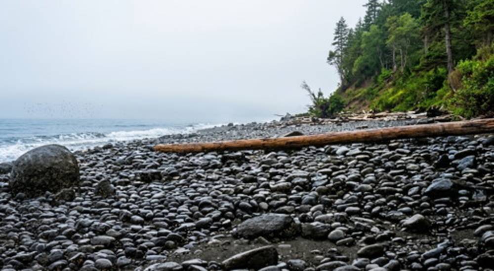
Fig. 11.20. An armored beach. Lag deposits of large rocks and cobbles are left on an eroded beach. The rocks on this beach are eroded from glacial deposit cliffs that contain a large assortment of particle sizes, from clays to boulders.
Some beach materials come to the beach from offshore areas. Coral and shell particles broken by the pounding action of the waves are carried to the beaches by the moving water. A beach covered with uniform small particles of sand or mud is or has been a depositional beach. Some of the world's beaches have distinctive colors. In Hawaii, there are white sand beaches derived from coral and black sand beaches derived from lava. Green sands can be found in areas where a specific mineral (such as olivine or glauconite) is available in large enough quantities, and pink sands occur in regions with sufficient shell material.
Dynamic Equilibrium and Seasonal Beach Processes. A sand beach exists because there is a balance between the supply and the removal of the material that forms it. A sand beach that does not appear to change with time is not necessarily static (no new material supplied, no old material removed) but is more likely to represent a dynamic equilibrium, the supply of material equaling the removal of material. The beach is continually changing, but it appears unchanged and remains in balance.
Natural Processes and Wave Action. The gentler waves of summer move sand shoreward and deposit it, where it remains until the winter. The large storm waves of winter remove the sand from the beach and transport it back offshore, to the sandbar. These processes occur alternately, winter and summer, leaving the beach rocky and bare each winter and covered with sand during the summer (fig. 11.21). These seasonal changes are fluctuations about the equilibrium state of the beach over a yearly cycle. Other changes also appear in a cyclic fashion, such as the arrival of more sand during periods of late winter and spring river flooding. If a beach annually receives as much material as it loses, the beach is in equilibrium and does not appear to change from year to year.
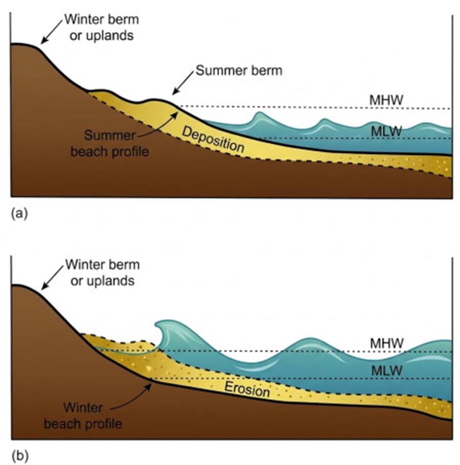
Fig. 11.21. Seasonal beach changes. (a) The small waves and average tides of summer move sand from offshore to the beach and form a summer berm. (b) The high waves and storm tides of winter erode sand from the beach and store it in offshore bars. Winter conditions remove the summer berm, leaving only the winter berm on the beach.
Single violent events may alter a beach. A great storm may arrive from such a direction that the usual beach current is reversed. A landslide may pile rubble across the beach and some distance into the water, interfering with the flow of sand along the beach. In either case, the beach changes because of changes in rates of sediment supply, transport, and removal. Waves moving toward a beach produce a current in the surf zone that moves water onshore and along the beach. This landward motion of water is called the onshore current, and this current transports suspended sediment toward the shore in what is called onshore transport. Waves usually do not approach a shore with their crests completely parallel to the beach but strike the shore at a slight angle. This pattern sets up a surf-zone longshore current that moves down the beach. Both onshore and longshore flow in the surf zone are illustrated in figure 11.22. The turbulence that occurs as the waves break in the surf zone tumbles the beach material into suspension in the water. The wave-produced longshore current displaces this sediment down the shore in the surf zone, producing a longshore transport. Along both coasts of the North American continent, the predominant longshore transport steadily moves the sediments in a southerly direction.
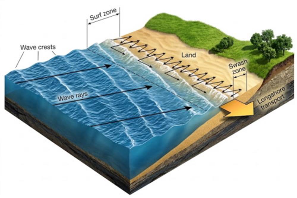
Fig. 11.22. Waves in the surf zone produce a longshore current that transports sediments down the beach. Arrows indicate onshore and longshore water movement.
Swash, Backwash, and Sediment Transport. The up-rush, or swash, of water from each breaking wave moves the sand particles diagonally up and along the beach in the direction of the longshore current. The backwash from the receding wave moves downslope toward the surf zone, but the backwash is weaker than the swash because much of the receding water percolates down into the sand. The combined action of the swash and backwash moves particles in a zigzag, or sawtoothed, path along the swash zone of the beach as part of the longshore transport. In 1994, on the beaches of North Carolina's Outer Banks near the town of Duck, scientists studied the movement of sediment in the swash zone. They attempted to find the answer to the puzzle of cusps, the evenly spaced, crescent-shaped depressions found along the sand and cobble beaches of both quiet coves and exposed shores (figs. 11.16b, and 11.23). The experimenters hoped to find whether cusps were the product of standing waves or the interactions between the beach slope and the water flow of the swash zone. The researchers bulldozed a section of beach to remove the cusps and then monitored their return. The results were inconclusive; the answer to the formation of cusps remains elusive.
Also in 1994 another group of coastal scientists began a project to study the movement of sediments in the surf zone. In this project, known as SANDYDUCK 94, more than 500 instruments were deployed, including acoustic sensors, optical sensors, and side-scan sonar. After spending three years analyzing their results, researchers returned in 1997 and 1998 to continue their search for a greater comprehension of beach dynamics and wave effects. The results of these studies are expected to improve their understanding of sand movements along coasts, into navigational channels, and around coastal structures. Such information is important to engineers constructing shoreline installations—for example, piers, breakwaters, and seawalls—and also to the military when planning troop and equipment movements in coastal areas.
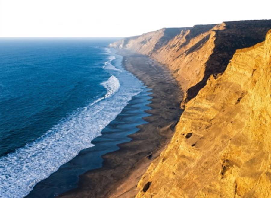
Fig. 11.23. At Point Reyes in California, wave action forms a series of cusps along a shore that has been made regular by wave erosion. How cusps form is not clearly understood.
Longshore Transport Mechanisms and Drift Sectors. The path traveled by beach sediments as the longshore current transports them from their source to their area of deposition is called a drift sector. Beaches within a drift sector usually remain in dynamic equilibrium and change little in appearance. Although there may be a large flow of material along the central portion of a drift sector, the amounts of sediment supplied and lost from the area are usually equal. At either end of the drift sector the beaches change with time. Areas at the sediment source are erosional; they are losing sediment. Areas at the depositional end of the drift sector are growing, or accreting. These processes are shown in figure 11.24. Although the longshore current is the usual transport mechanism within a drift sector, in some places tidal currents and coastal currents associated with large-scale oceanic circulation affect sediment transport.
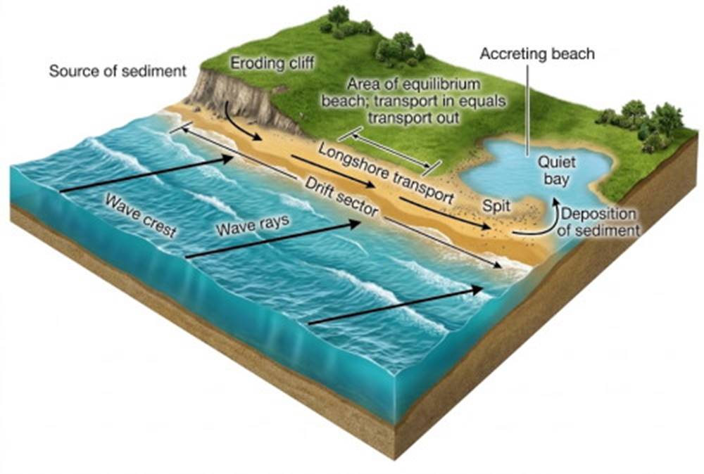
Fig. 11.24. A drift sector extends down the coast from the sediment source to the area of deposit.
Coastal Circulation. Onshore transport accumulates water as well as sand along a beach. This water must flow back out to sea and will do so one way or another. A headland may deflect the longshore current seaward, or the water flowing along the beach can return to the area beyond the surf zone in quieter water, such as areas over troughs or depressions in the sea floor. Regions of seaward return are frequently narrow and fast-moving. These are the rip currents that carry sediment through the surf zone (fig. 11.25); rip currents are also discussed in chapter 9 (see fig. 9.21). Just seaward of the surf, the rip current dissipates into an eddy. Some of the sediment is deposited here in quieter deeper water and is lost from the downbeach flow. However, some is returned to shore with the onshore transport on either side of the rip current. This cycle of partial return of sediments to the beach, transport along the beach, transport back to sea in another rip current, and return again to the beach is a part of a drift sector.
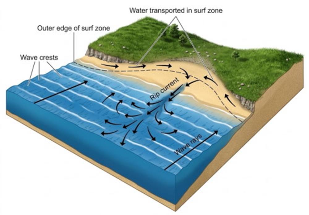
Fig. 11.25. Rip currents form along a beach in areas of low surf and reduced onshore flow.
A series of these drift sectors, when linked together along a stretch of coast, forms a coastal circulation cell. In a major coastal circulation cell, the seaward transport of sediment results in deposits far enough offshore to prevent any recycling. At the end of a coastal circulation cell the longshore transport is deflected away from the beach and the sand moves across the continental shelf and down a submarine canyon to the ocean basin floor. This sand has been removed from the coastal system, and sand beaches disappear beyond this point until a new source contributes sand to form the next coastal circulation cell. South of Point Conception in southern California, oceanographers recognize four distinct coastal circulation cells (fig. 11.26). Each cell begins and ends in a region of rocky headlands, where beaches are sparse and submarine canyons are found offshore. Beaches become wider as river sources contribute their sand to the longshore current, and at the end of each cell, the current deposits the sediment in a submarine canyon, where it cascades to the ocean basin floor. Beaches just south of the canyon are sparse, and a new cell begins. Refer to chapter 3 for a discussion of submarine canyons.
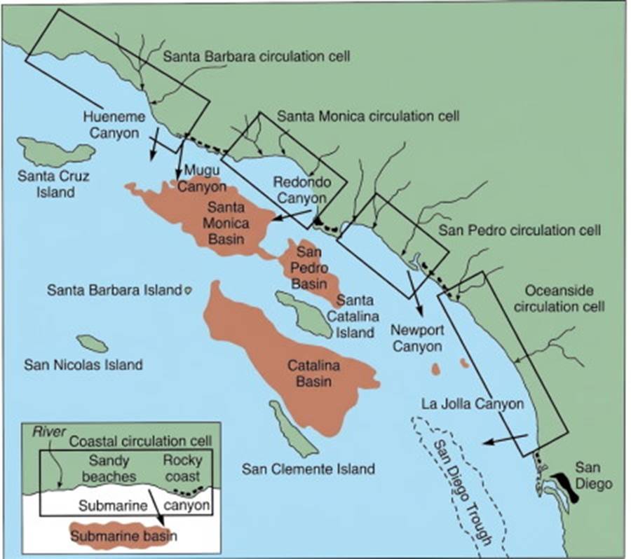
Fig. 11.26. Major coastal sediment circulation cells along the California coast. Each cell starts with a sediment source and ends where beach material is transported into a submarine canyon. D. L. Inman and J. D. Frautschy, Littoral Processes and the Development of Shorelines, 1965, pp. 511–536. Coastal Engineering, ASCE, New York. Reprinted by permission of the authors.
Estimates of the rate at which sediments are moved along a beach are made by observing the rate at which sand is deposited, or accreted, on the upstream side of an obstruction or by observing the rate at which sand spits migrate. Transport of sand along a section of coast varies between zero transport and several million cubic meters per year. Average values fall between 150,000 m³/yr and 1,500,000 m³/yr; 150,000 m³ is more than 30,000 dump-truck loads. Once the enormous volume of the naturally moving sand is recognized, it becomes apparent why poorly designed harbors fill very quickly, beaches disappear, and spits migrate a considerable distance during a year. It also becomes obvious that the effort required to keep pace with the supply by dredging or pumping operations is enormously expensive and in many cases impossible.
The forces that supply the energy for the movement of beach materials come from the waves and the wave-produced currents. Surface winds supply about 10⁴ watts of power to the ocean surface to produce the waves and currents. There are about 440,000 km (264,000 mi) of coastal zone in the world, and approximately half of this coast is exposed directly to the ocean waves. Ocean waves average 1 m (3.3 ft) in height and produce power that is equivalent to 10⁴ watts for each meter of exposed coastline. Under storm conditions, the wave height averages about 3 m (10 ft), and a meter of coastline receives 10⁵ watts. It is this supply of energy that causes the beach erosion, the suspension of beach material, and the migration of beach sand along the narrow coastal zone.
Date added: 2026-11-09; views: 10;