
Ocean Tides: Patterns, Tidal Forces, and Equilibrium Theory
Tide Patterns. Measurements of tidal movements around the world show us that the tides behave differently in different places. In some coastal areas there is a regular pattern of one high tide and one low tide each day; this is a diurnal tide. In other areas there is a cyclic high water–low water sequence that is repeated twice in one day; this is a semidiurnal tide. In a semidiurnal tidal pattern, the two high tides reach about the same height and the two low tides drop to about the same level.
A tide in which the high tides regularly reach different heights and the low tides drop regularly to different levels is called a semidiurnal mixed tide. This type of tide has what is called diurnal (or daily) inequality, created by combining diurnal and semidiurnal tide patterns. The tide curves in figure 10.1 show each type of tide. Curves for typical tides at some U.S. coastal cities are shown in figure 10.2.
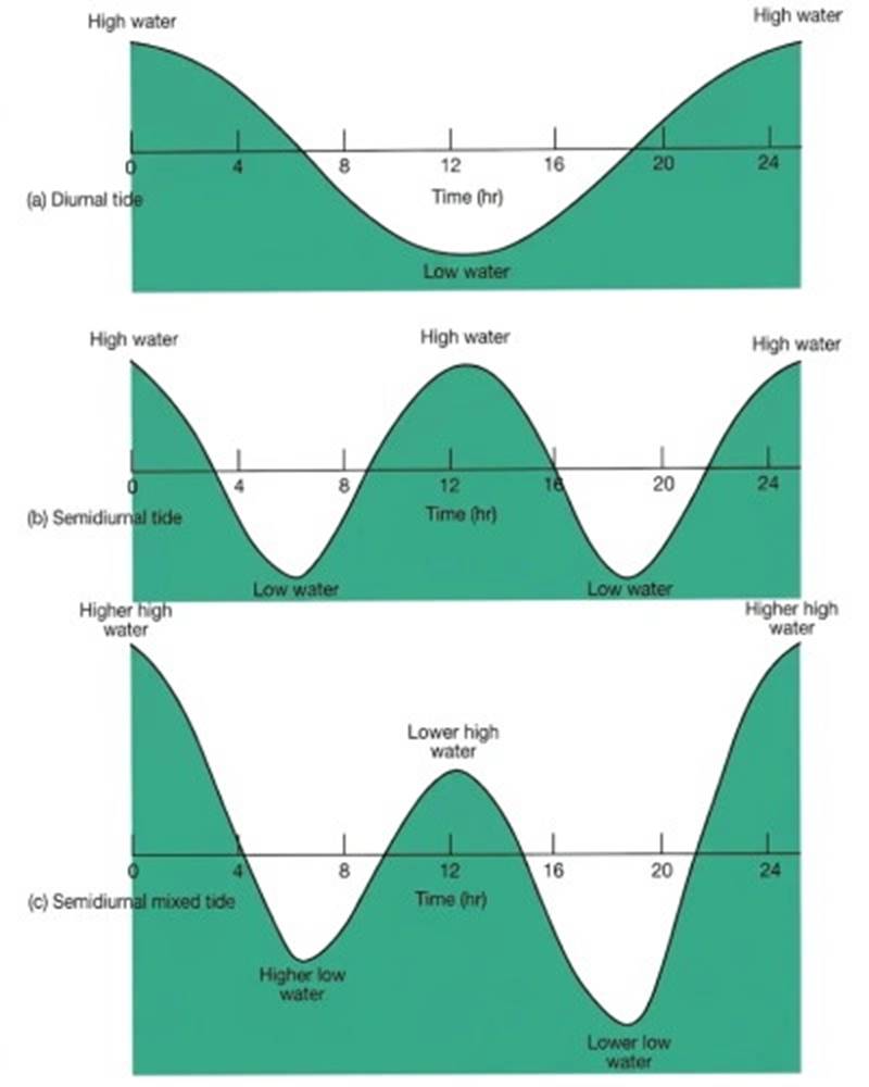
Fig. 10.1. The three basic types of tides: (a) a once-daily, diurnal tide; (b) a twice-daily, semidiurnal tide; and (c) a mixed semidiurnal tide with diurnal inequality.
Tide Levels. In a uniform diurnal or semidiurnal tidal system, the greatest height to which the tide rises on any day is known as high water, and the lowest point to which it drops is called low water. In a mixed-tide system, it is necessary to refer to higher high water and lower high water, as well as higher low water and lower low water (see fig. 10.1).
Tide measurements taken over many years are used to calculate the average (or mean) tide levels. Averaging all water levels over many years gives the local mean tide level. Averages are also calculated for the high water and low water levels, as mean high water and mean low water. For mixed tides, mean higher high water, mean lower high water, mean higher low water, and mean lower low water are calculated.
Because the depth of coastal water is important to safe navigation, an average low water reference level is established; depths are measured from this level for navigational charts. The tide level is added to this charted depth to find the true depth of water under a vessel at any particular time. In areas of uniform diurnal or semidiurnal tide patterns the zero depth reference, or tidal datum, is usually equal to mean low water.
The use of mean low water assures the sailor that the actual depth of the water is, in general, greater than that on the chart. In regions with mixed tides, mean lower low water is used as the tidal datum, for the same reason. When the low tide level falls below the mean value used as the tidal datum, a minus tide results. A minus tide can be a hazard to boaters, but it is cherished by clam diggers and students of marine biology, because it exposes shoreline usually covered by the sea.
As the water level along the shore increases in height, the tide is said to be rising or flooding; a rising tide is a flood tide. When the water level drops, the tide is falling or ebbing; a falling tide is an ebb tide.
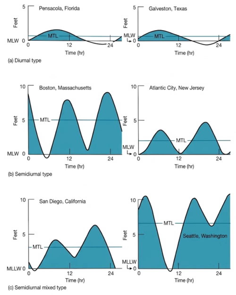
Fig. 10.2. Tide types and tidal ranges vary from one coastal area to another. The zero tide level equals mean low water (MLW) or mean lower low water (MLLW), as appropriate. MTL equals mean tide level. All tide curves are for the same date.
Tidal Currents. Currents are associated with the rising and falling of the tide in coastal waters. These tidal currents may be extremely swift and dangerous as they move the water into a region on the flood tide and out of the region on the ebb tide. When the tide turns, or changes from an ebb to a flood or vice versa, there is a period of slack water, during which the tidal currents slow and then reverse.
Slack water may be the only time that a vessel can safely navigate a narrow channel with swiftly moving tidal currents, sometimes in excess of 5 m/s (10 knots). The relationships of tidal currents to standing wave tides, to progressive tides, and to tidal current prediction are discussed in later sections of this chapter.
Equilibrium Tidal Theory. Oceanographers analyze tides in two ways. The tides are studied as mathematically ideal wave forms behaving uniformly in response to the laws of physics. This method of study is called equilibrium tidal theory. It is based on an Earth covered with a uniform layer of water, in order to simplify the study of relationships between the oceans and the tide-rising bodies, the Moon and the Sun.
The tides are also studied as they occur naturally; this method is called dynamic tidal analysis. It studies the oceans' tides as they occur, modified by the landmasses, the geometry of the ocean basins, and the Earth's rotation. The effects of the Sun's and the Moon's gravity and of the rotation of the Earth on tides are most easily explained by studying equilibrium tides. In this discussion the Earth and the Moon act as a single unit, the Earth-Moon system that orbits the Sun; refer to figure 10.3.
The Moon orbits the Earth, held by the Earth's gravitational force acting on the Moon (B in fig. 10.3a). There is also a force acting to pull the Moon away from the Earth and send it out into space (B′ in fig. 10.3b). In the first part of this discussion B′ is considered a centrifugal force. A centrifugal force is an apparent force present when one judges motion against a rotating frame of reference. Forces B and B′ must be equal and opposite to keep the Moon in its orbit.
Likewise the Moon's gravitational force acting on the Earth (C in fig. 10.3a) must be balanced by the apparent, or centrifugal, force (C′ in fig. 10.3b). B′ and C′ are present because the Earth-Moon system is rotating about a common axis at the system's center of mass, which is located 4640 km (2880 mi) from the Earth's center along a line between the Earth and the Moon. The Earth-Moon system is held in orbit about the Sun by the Sun's gravitational attraction (A in fig. 10.3c), while a centrifugal force again acts to pull the Earth-Moon system away from the Sun (A′ in fig. 10.3c). For the Earth-Moon system to remain in solar orbit, the gravitational forces must equal the centrifugal forces (fig. 10.3c).
Newton's Law of Universal Gravitation. Sir Isaac Newton's universal law of gravitation tells us that the force of attraction between any two bodies is proportional to the product of the two masses divided by the square of the distance between the centers of the masses:
F = G (m₁m₂ / R²),
where
G = universal gravitational constant, 6.67 × 10⁻⁸ cm³/g·s²;
m₁ = mass of body 1 in grams;
m₂ = mass of body 2 in grams;
R = distance between centers of masses in centimeters.
If the gravitational forces are calculated for each unit mass of material at the Earth's surface and at its center, the gravitational forces at the Earth's surface change with location because of the changing distance between a unit mass on the Earth's surface and the center of the Sun or Moon. The centrifugal force acting on each unit mass on the Earth is constant and is equal and opposite to the gravitational force acting on a unit mass at the Earth's center.
The difference in force per unit mass between the gravitational force of the Moon or the Sun and the centrifugal force at an Earth surface point is proportional to G(M/R³), where G is the gravitational constant, M is the mass of the Moon or the Sun, and R is the distance between the centers of the Earth and the Moon or between the centers of the Earth and the Sun.
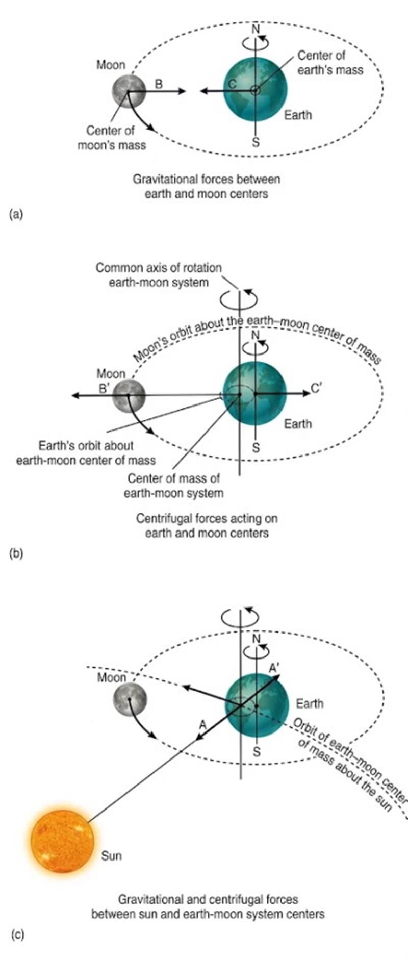
Fig. 10.3. Gravitational and centrifugal forces act to keep the Earth-Moon system in balance.
The Moon Tide and Tide-Raising Forces. The gravitational force exerted by the Moon on a unit mass is larger at the point on the Earth's surface that is closest to the Moon than on a unit mass at the Earth's center, because the distance between the Earth's surface and the Moon is R − r. The quantity r is the radius of the Earth.
The gravitational force difference or excess acting toward the Moon pulls a unit mass away from the Earth's center and produces a tide-raising force. At a point on the side of the Earth opposite the Moon, the gravitational force is less than the constant centrifugal force because the distance is R + r. The centrifugal force difference or excess that pulls a unit mass away from the Earth's center is also a tide-raising force. The calculation of these tide-raising forces is shown in appendix C.
A second way to understand tide-raising forces is to think of the Sun or the Moon as exerting a gravitational force that continuously accelerates the Earth toward the Sun or toward the Moon. In this case the gravitational force, or centripetal force, of the Sun or the Moon holds the Earth in orbit. The centripetal force is constant and is equal to the average gravitational force of the Sun or the Moon acting at the Earth's center.
In this case the difference between the average gravitational attraction and the gravitational attraction at individual points on the Earth produces the tide-raising force. The force difference per unit mass between a surface point and the Earth's center is proportional to G(MR³) in this second case as well. The two approaches yield the same results. The derivation of G(MR³) is found in appendix C.
In the Earth-Moon-Sun system, the mass of the Sun is very great, but the Sun is very far away. By contrast, the Moon is small, but it is close to the Earth. Calculating the distribution of these unbalanced forces for each water particle at the Earth's surface shows that the Moon has a greater attractive effect on the water particles than the Sun. In the following discussion the effects of each tide-raising body will be considered separately.
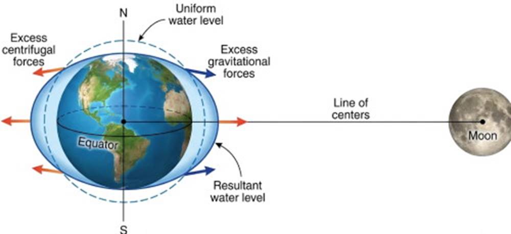
Fig. 10.4. Distribution of tide-raising forces on the Earth. Excess lunar gravitational and centrifugal forces distort the Earth model's water envelope to produce bulges and depressions.
The Moon Tide and The Tidal Day. The water particles on the side of the Earth facing the Moon are closest to the Moon and are acted on by the excess Moon gravitational force. Because the water covering is liquid and deformable, this force moves the water particles of the Earth's surface toward a point directly under the Moon. This movement produces a bulge in the water covering.
At the same time, the centrifugal force of the Earth-Moon system acting on the water particles at the Earth's surface opposite the Moon creates an opposing bulge. This centrifugal force is equal to the magnitude of the excess gravity tide-raising force and is proportional to −G(M/R³). The minus sign indicates that this excess centrifugal force is acting opposite to the Moon's tide-producing gravity force.
If we place the Moon opposite the Earth's equator and then stop the Moon model and its Moon in space and time, we see the bulges in the water covering, as shown in figure 10.4. Remember that our model Earth initially had a water covering of uniform depth; therefore, as the two bulges are created, an area of low-water level is formed between the bulges. We now have a water covering with two bulges and two intervening depressions (or two crests and two troughs, or two high tide levels and two low tide levels) distributed around the equator.
The Earth makes one rotation in about twenty-four hours, and the bulges (or crests) in the water covering tend to stay under the tide-producing body as the Earth turns. As a result of this movement, a point on Earth that is initially at a crest (or high tide) passes to a trough (or low tide), to another high tide, to another low tide, and back to the original high tide as the Earth completes one revolution.
You can follow this process in figure 10.5. The effect created by the motion of the Earth as it turns to the east when observed from space can also be interpreted as a wave form, for the bulges in the water covering move westward when observed relative to a fixed position on the Earth.
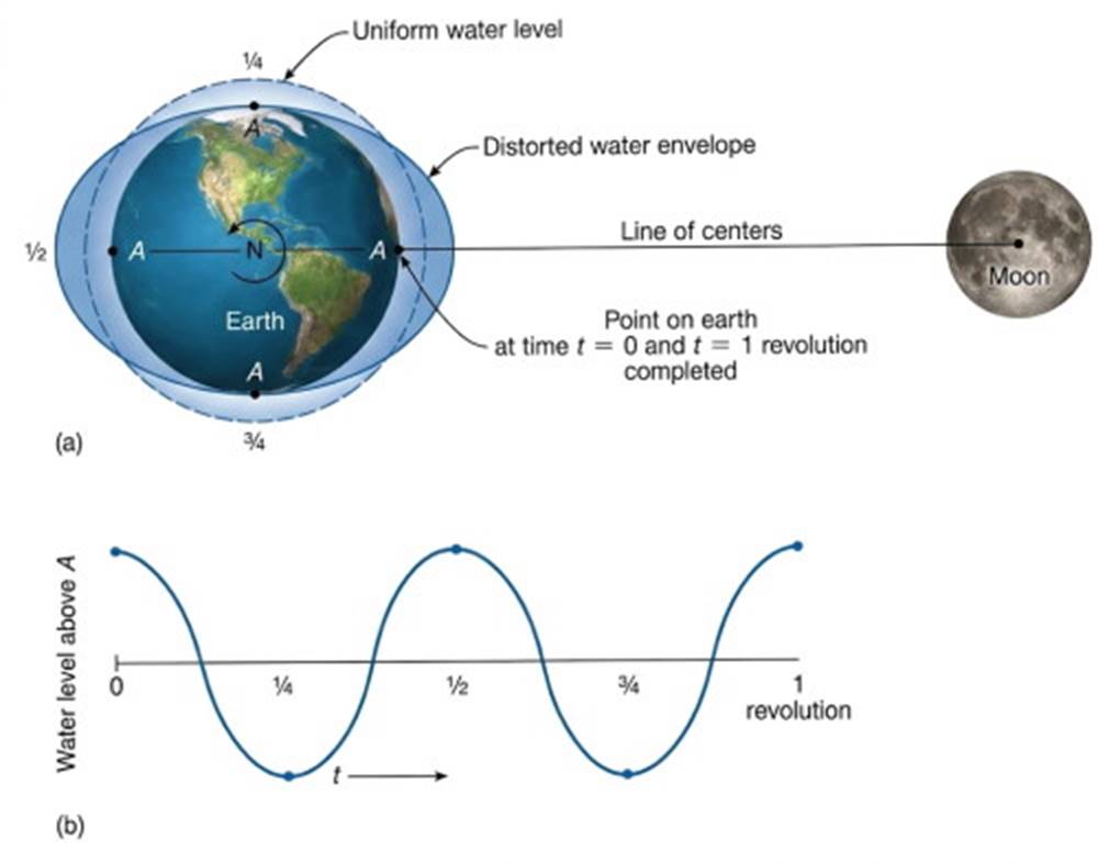
Fig. 10.5. The change in water level at point A during one Earth rotation through the distorted water envelope. (Refer to fig. 10.4). Fractions indicate portions of a revolution.
The Tidal Day. While the Earth turns eastward upon its axis, the Moon is moving in the same direction along its orbit about the Earth. After twenty-four hours the Earth point that began directly under the Moon is no longer directly under the Moon. The Earth must turn for an additional fifty minutes, about 12°, to bring the starting point on the Earth back in line with the Moon.
Therefore, a tidal day is not twenty-four hours long but twenty-four hours and fifty minutes long. This difference also explains why corresponding tides arrive at any location about one hour later each day. This relationship is shown in figure 10.6.
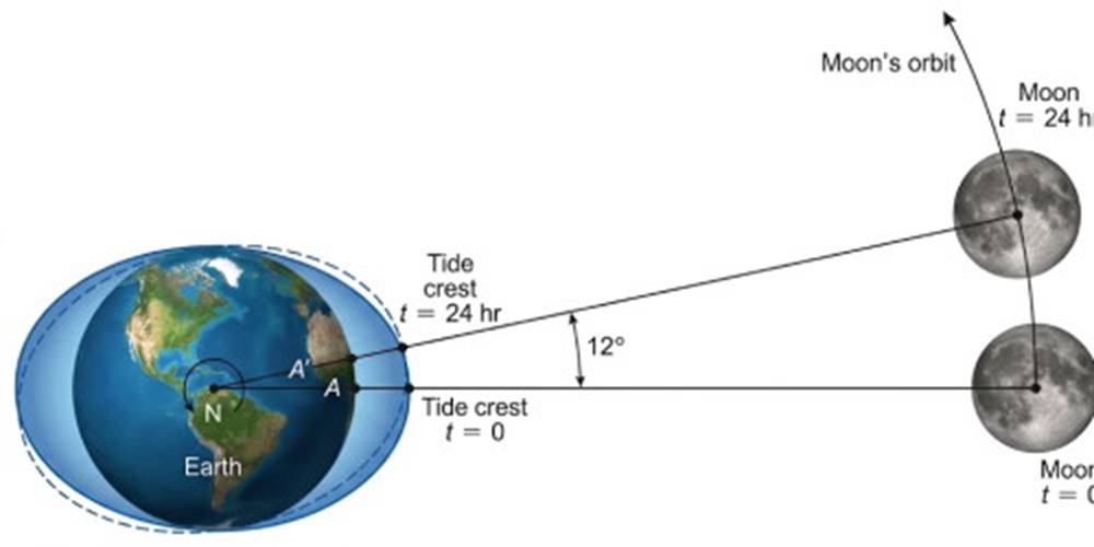
Fig. 10.6. Point A requires twenty-four hours to complete one Earth rotation. During this time the Moon moves 12° east along its orbit, carrying with it the tide crest. To move from A to A′ requires an additional fifty minutes to complete a tidal day.
The Tide Wave. The tides produced in this example are semidiurnal, with two highs and two lows each day. The tidal distortion of the model's water covering produces a wave form known as the tide wave. The crest of the tide wave is the high water level, and the trough of the tide wave is the low water level. The wavelength in this example is half the circumference of the Earth, and the tide wave's period is about twelve hours and twenty-five minutes.
The Sun Tide. Although the Moon plays the greater role in the tide-producing process, the Sun produces its own tide wave. Despite the Sun's large mass, it is so far away from the Earth that its tide-raising force is only 46% that of the Moon. The time required for the Earth to revolve on its axis with respect to the Sun is on the average twenty-four hours, not twenty-four hours and fifty minutes, as in the case of the Moon tide.
For this reason, the tide wave produced by the Moon is not only of greater magnitude than that produced by the Sun, but it also continually moves eastward relative to the tide wave produced by the Sun. Because the tidal forces of the Moon are greater than those of the Sun, the tidal period of the Moon is more important; and the tidal day is considered to be twenty-four hours and fifty minutes.
Spring Tides and Neap Tides. The Moon's orbit requires 29½ days relative to a point on the Earth. During this period the Sun, the Earth, and the Moon move in and out of phase with each other. At the new Moon, the Moon and Sun are on the same side of the Earth, so the high tides, or bulges, produced independently by the Moon and the Sun coincide (fig. 10.7).
Because the water level is the result of adding the two wave forms together, tides of maximum height and depression, or tides with the greatest range between high water and low water, are produced. These tides are known as spring tides. The vertical displacement, or amplitude, of the tide is one-half the range—the distance above or below mean tide level.
In a week's time, the Moon is in its first quarter; it has moved eastward along its orbit (about 12° per day) and is located approximately at right angles (or 90°) to the line of centers of the Earth and Sun. The crest, or bulge, of the Moon tide is at right angles to the tide wave created by the Sun; the crests of the Moon tide will coincide with the troughs of the Sun tide, and the same will be true of the Sun's tide crests and the Moon's tide troughs (fig. 10.7).
The crests and troughs then tend to cancel each other out, and the range between high water and low water is small, producing low-amplitude neap tides. At the end of another week the Moon is full, and the Sun, Moon, and Earth are again lined up, producing crests that coincide and tides with the greatest range between high and low waters, or spring tides.
These spring tides are followed by another period of neap tides, produced by the Moon in its last quarter when it again stands at right angles to the Sun (fig. 10.7). The tides follow a four-week cycle of changing tidal amplitude, with spring tides occurring every two weeks, and a period of neap tides occurring in between. This progression can be seen in the portions of the tide records reproduced in figure 10.8. The effect occurs each lunar month and is the result of the Moon's tide wave moving around the Earth relative to the Sun's tide wave.
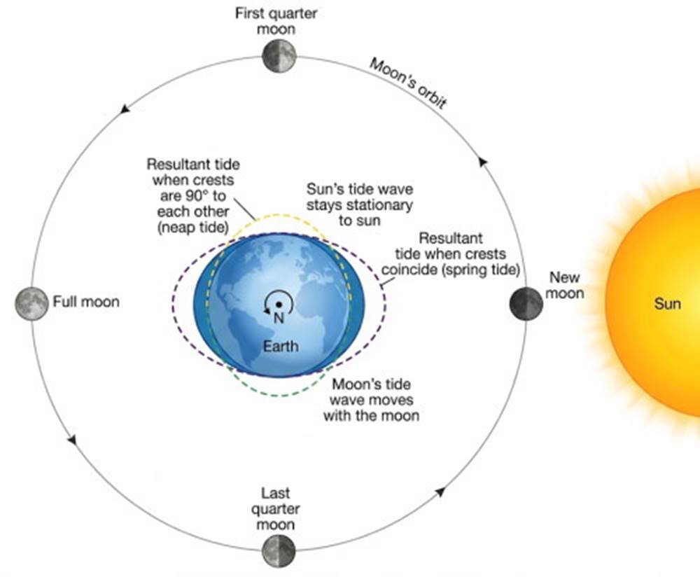
Fig. 10.7. Spring tides result from the alignment of the Earth, Sun, and Moon during the full Moon and the new Moon. During the Moon's first and last quarters, neap tides are produced.
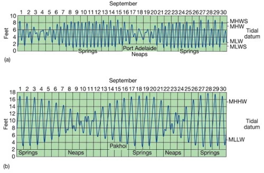
Fig. 10.8. Spring and neap tides alternate during the tides' monthly cycle. MHWS is the mean high water spring tides; MLWS is mean low water spring tides. (a) A semidiurnal tide from Port Adelaide, Australia. (b) A diurnal tide from Pakhoi, China.
Declinational Tides. If the Moon or the Sun stands north or south of the Earth's equator, one bulge, or high water, is in the Northern Hemisphere and the other is in the Southern Hemisphere (fig. 10.9). Under these conditions, a point at the middle latitudes on the Earth's surface passes through only one crest, or high tide, and one trough, or low tide, each tidal day. A diurnal tide, often called a declinational tide, is formed, because the Moon or the Sun is said to have declination when it stands above or below the equator.
Declinational (or diurnal) tides are influenced by both the Moon and the Sun. The Sun stands above 23½°N at the summer solstice and above 23½°S at the winter solstice. This variation causes the bulge created by the Sun to oscillate north and south of the equator in a regular fashion each year and tends to create more diurnal Sun tides during the winter and summer than during the spring and fall.
The Moon's declination varies between 28½°N and 28½°S with reference to the Earth. The Moon's orbit is inclined 5° to the Earth-Sun orbit, and it takes 18.6 years for the Moon to complete its cycle of maximum declination. When the Sun's and the Moon's declinations coincide, both tide waves become more diurnal. Each lunar month the Moon travels from a declination of 5° above the Earth-Sun orbit plane to a declination of 5° below the plane and back to the high declination.
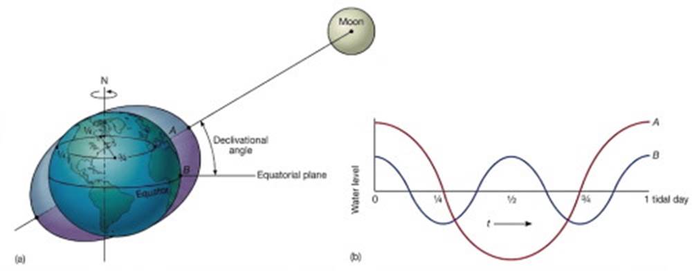
Fig. 10.9. (a) The declination of the Moon produces a diurnal tide at latitude A and a semidiurnal tide at latitude B. (b) Fractions indicate portions of the tidal day.
Elliptical Orbits. The Moon does not move about the Earth in a perfectly circular orbit, nor does the Earth orbit the Sun at a constant distance. These orbits are elliptical, and therefore the Earth is closer to a certain tide-raising body at some times during an orbit than at other times. During the Northern Hemisphere's winter, the Earth is closest to the Sun; therefore the Sun plays a greater role as a tide producer in winter than in summer.
Date added: 2026-11-09; views: 5;