
The Dynamics of Tide Waves: Progressive, Standing, and Basin Effects
Dynamic Approach and Tide Wave Characteristics. Equilibrium tidal theory helps us understand the distribution of wave-level changes and tide-raising forces, but it does not explain the tides as observed on the real Earth. Return to figure 10.2 and notice the variety of tidal ranges and tidal periods that appear at different locations on the same date. Refer also to figure 10.8, showing different tides at different places during the same time period. The Sun-Moon-Earth system for all locations in the two figures is the same, but the equilibrium tidal theory does not explain natural tides at any particular location. Investigating the actual tides requires the dynamic approach, a mathematical study of tide waves as they occur.
Equilibrium Theory Constraints. The behavior of the natural tide wave varies considerably from the tide wave of the water-covered model. Because the continents separate the oceans, the tide wave is discontinuous; the wave starts at the shore, moves across the ocean, and stops at the next shore. Only in the Southern Ocean around Antarctica do the tide waves move continuously around the Earth. A tide wave has a long wavelength compared with the depth of the oceans; therefore it behaves like a shallow-water wave, with its speed controlled by the depth of the water.
Because the wave is contained within the ocean basins, it can oscillate in the basin as a standing wave, and it is also reflected from the edge of the continents, refracted by the change in water depth, and diffracted as it passes through gaps between continents. In addition, the persistence of the tidal motion and the scale on which it occurs are so great that the Coriolis effect plays a role in the water's movement. All these factors together produce the Earth's real tides, and because their interactions are complex, it is not possible to understand them together until each is first considered separately.
Tide Wave Behavior and Forced Waves. The tide wave's speed as a free wave moving across the water's surface is determined by the depth of the water. The tide wave moves as a free wave at about 200 m/s (400 mi/h) in a water depth of 4000 m (13,200 ft), but at the equator the Earth moves eastward under the tide wave at 463 m/s (1044 mi/h). This is more than twice the speed at which the tide can travel freely as a shallow-water wave. Under these conditions, the tide moves as a forced wave that is the result of the Moon's attractive force and the Earth's rotation.
Because the Earth turns eastward faster than the tide wave moves freely westward, friction displaces the tide crest to the east of its expected position under the Moon. This eastward displacement continues until the friction force is balanced by a portion of the Moon's attractive force. These two forces, when balanced, hold the tide crest in a position to the east of the Moon rather than directly under it. This process is illustrated in figure 10.10.
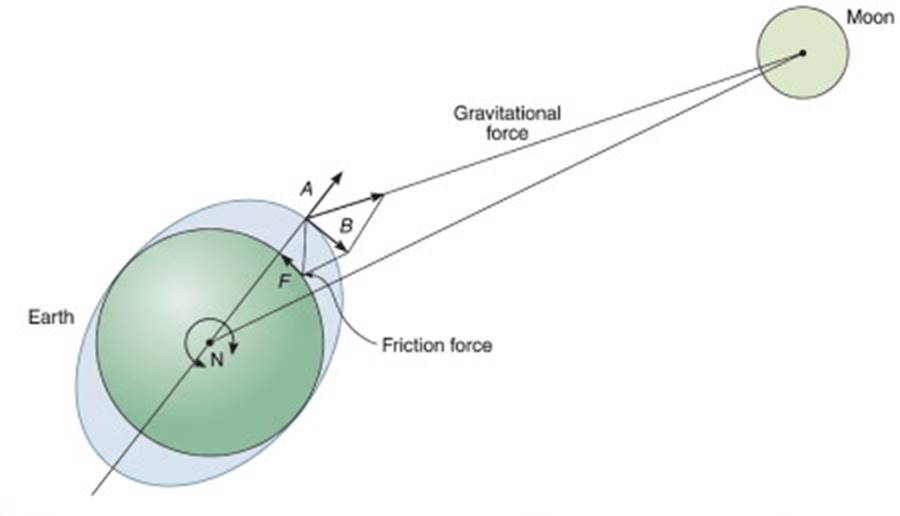
Fig. 10.10. The crest of the tide wave is displaced eastward until the B component of the gravitational force balances the friction (F) between the Earth and the tide wave. Component A of the gravitational force is the tide-raising force. Component B causes the tide wave to move as a forced wave.
Above 60°N or 60°S, the distance around a latitude circle is less than one-half the distance around the equator. Here, the free propagation speed of the tide wave equals the rotation rate of the Earth, adding about 1½ milliseconds per 100 years to the length of a day.
Progressive Tides and Coriolis Effects. In a large ocean basin the tide wave moving across the sea surface like a shallow-water wave is a progressive tide. Examples of progressive tides are found in the western North Pacific, the eastern South Pacific, and the South Atlantic oceans. Cotidal lines are drawn on charts to mark the location of the tide crest at set time intervals, generally one hour apart. The cotidal lines for the world's ocean tides are shown in figure 10.11 and box figure 10.1.
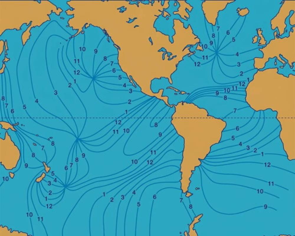
Fig. 10.11. Cotidal lines for the world's oceans. The high-tide crest occurs at the same time along each cotidal line. Positions of the high tide are indicated for each hour over a twelve-hour period for semidiurnal tides.
Because the tide wave is a shallow-water wave, the water particles move in elliptical orbits, and their motion extends to the sea floor. The horizontal component of the motion greatly exceeds the vertical motion. Because the time in which the water particles move in one direction is so long (one-half the tide period), the Coriolis effect becomes important. In the Northern Hemisphere the water particles are deflected to the right, and in the Southern Hemisphere they are deflected to the left. This deflection causes a clockwise rotation of the water in the Northern Hemisphere and a counterclockwise rotation in the Southern Hemisphere. This circular (or rotary) movement is the oceanic tidal current described at the end of Standing Wave Tides; see below.
Standing Tides and Amphidromic Systems. In some ocean basins or parts of ocean basins, the tide wave is reflected from the edge of the continents, and a standing wave is produced; refer to chapter 9. Remember that if a container of water is tipped so that the water level is high at one end and low at the other, the water flows to the low end, raising the water level at that end as the water level at the high end drops. This movement produces a wave having a wavelength that is twice the length of the container, with antinodes at the ends of the basin and a node at the basin's center. This same process occurs in ocean basins, but with some important modifications.
For the water to flow from the high water side to the low water side of an ocean basin requires a long time, and the Coriolis effect must be included. The moving water, deflected to the right in the Northern Hemisphere, does not reach the low tide end but instead is deflected to a position to the right of the initial high tide position. This movement causes the tide crest to rotate counterclockwise around the basin in which it oscillates, but the tidal current rotates clockwise, because the current is deflected to the right in the Northern Hemisphere (Refer to fig. 10.13.). In the Southern Hemisphere these directions are reversed.
Rotary Standing Tides. In the rotary standing tide wave, the node becomes reduced to a central point, while the tide crests (shown as cotidal lines) progress around the edges of the basin (See fig. 10.11 for a demonstration of this pattern in the northeastern and southwestern Pacific and in the north Atlantic.) The central point, or node, for a rotary tide is called the amphidromic point. The distance between low- and high-water levels, or the tidal range, for a rotary tide is shown on a chart by a series of lines decreasing in value as they approach the amphidromic point.
The lines of equal tidal range are called corange lines (fig. 10.12). Near the amphidromic point the tidal range is small; the farther from the amphidromic point, the greater the range. Because the amphidromic point is located near the center of an ocean basin, many mid-ocean areas have small tidal ranges, while the shores of the landmasses forming the sides of the basins have larger tidal ranges. The value and position of corange lines in mid-ocean are not as well known as they are near shore.
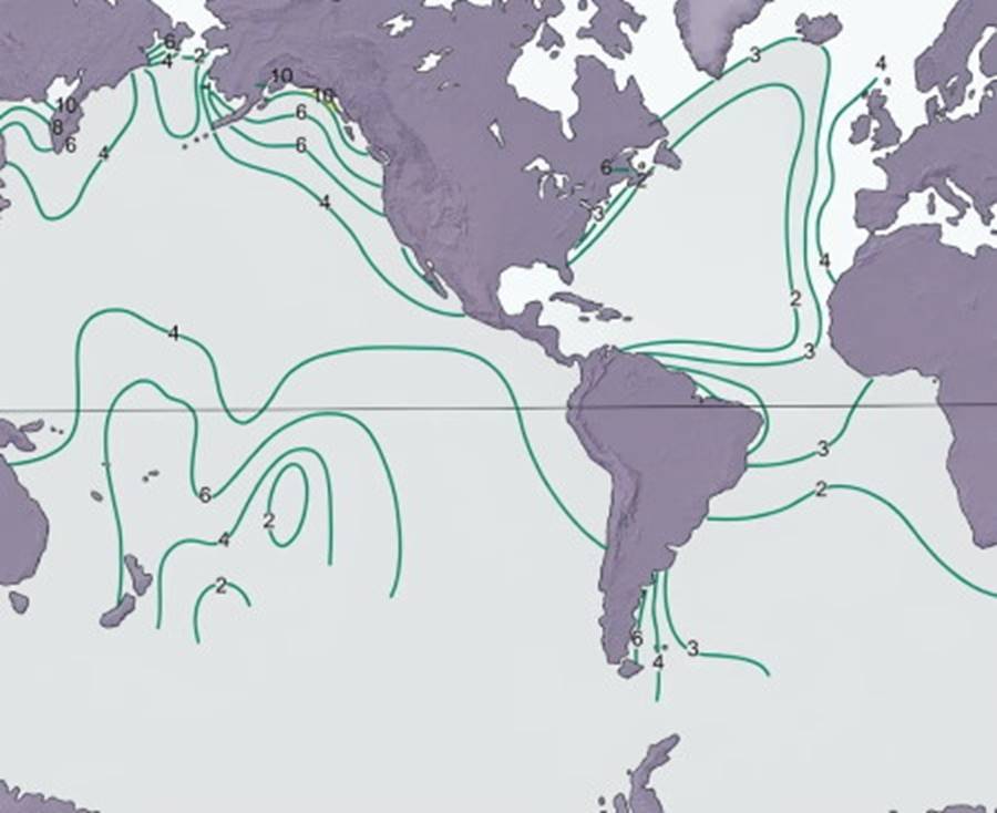
Fig. 10.12. Corange lines for the world's oceans. These corange lines connect positions with the same spring tidal range. Open-ocean tidal ranges are less well known than nearshore ranges, where tide level recorders are commonly used. Satellites now measure water elevation changes in mid-ocean; see the box in this chapter.
The flow of water from the high-water side to the low-water side of a standing tide wave produces a rotating tidal current, as shown in figure 10.13. A rotating tidal current is also produced by the orbital motion of water particles in a progressive tide wave. If the tide wave is diurnal, the water particles travel in one complete circle in a tidal day. A semidiurnal tide causes two circles, and a semidiurnal mixed tide produces two circles of unequal size. An example of a rotating semidiurnal mixed tidal current recorded at the Columbia River Lightship in the North Pacific is presented in figure 10.14.
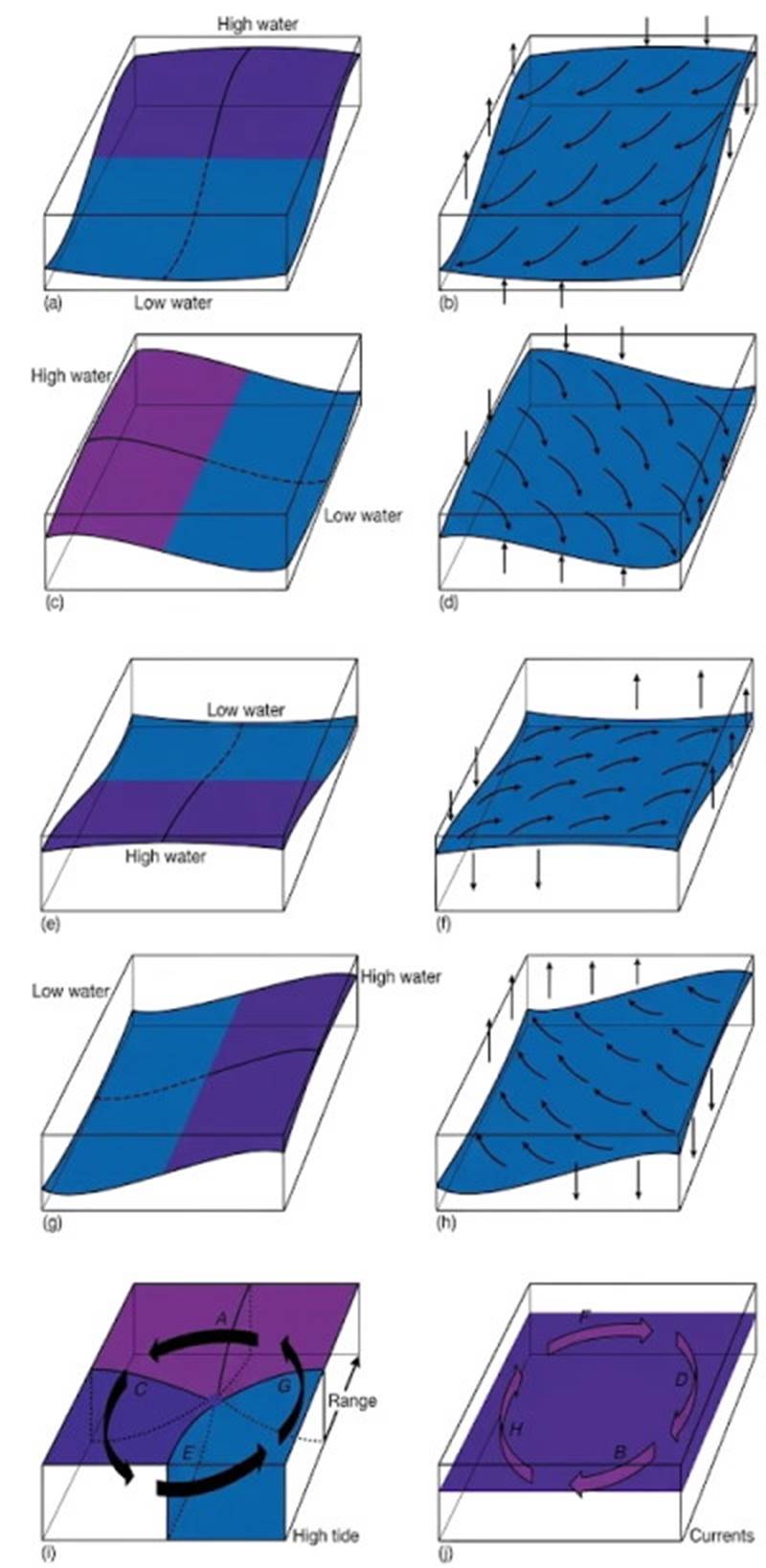
Fig. 10.13. Rotary standing tide waves. At the instant high tide occurs at one side of the basin (a), the water begins to flow toward the low-tide side, creating a tidal current (b) that is deflected to its right in the Northern Hemisphere. The current displaces the high tide counterclockwise from (a) by way of (b) to (c). The process continues from (c) by way of (d) to (e), from (e) by way of (f) to (g), and from (g) by way of (h) to (a). This process results in a tide wave that rotates counterclockwise about the amphidromic point (i) and a tidal current that flows clockwise (j).
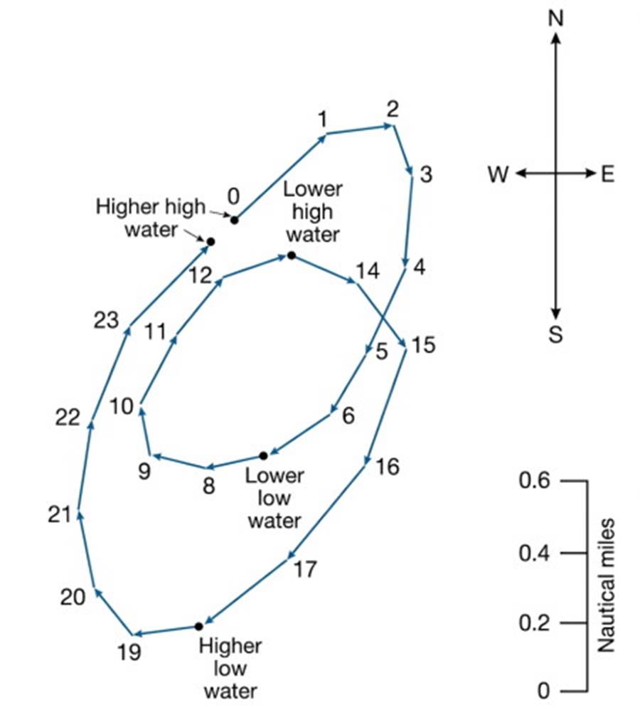
Fig. 10.14. Ocean tidal currents are rotary currents. The arrows trace the path followed by water particles in a tide wave during a mixed tidal cycle. Two unequal tidal cycles are shown. Numbers indicate consecutive hours in each tidal stage. The Coriolis effect deflects the horizontal component of the water particles' orbital motion, causing them to move in a circular path.
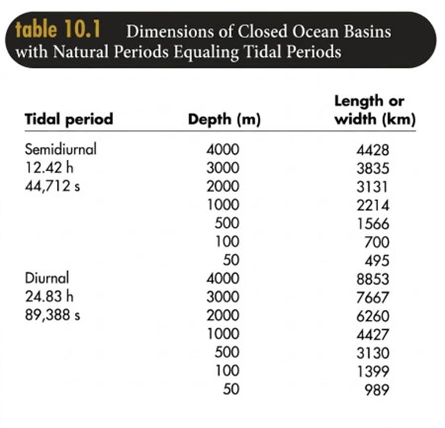
Basin Resonance. Rotary standing tides occur in basins in which the natural period of the basin approximates the tidal period. If the tidal period and the oscillation period of the basin coincide, the tides increase in amplitude. Table 10.1 relates basin depths and lengths or widths that produce natural oscillations equal to tidal periods. Remember from chapter 9 that the natural period of oscillation of a standing wave in a basin is T = (1/n) (L / √(gD)), where L, the wavelength, is twice the basin length, l, in closed basins and four times l in open-ended basins.
A comparison of the values given in table 10.1 shows that deep-ocean basins must have great length to accommodate standing waves with tidal periods, whereas shallow basins may be much shorter. Most tides are semidiurnal, but dimensions of some basins cause the basin to resonate with a diurnal tidal period rather than a semidiurnal period. See the tide curves in figure 10.2 for Pensacola, Florida, and Galveston, Texas.
In an open-ended tidal basin with a mixed tide, the semidiurnal portion of the tide may cause the basin to resonate with a node at the entrance to the basin and another node within the basin. The diurnal portion of the tide may have only a single node at the basin entrance. The result is a diurnal water-level pattern at the second node of the semidiurnal tide and a semidiurnal mixed pattern in all other parts of the basin. The harbor of Victoria, British Columbia, Canada is located near a semidiurnal node so that it registers a diurnal tidal pattern in an inlet system of mixed tides. Ocean tides are the result of combining progressive and standing wave tides with diurnal and semidiurnal characteristics. Different kinds of tides interact with each other along their boundaries, and the results are exceedingly complex.
Tide Waves in Narrow Basins. Unlike ocean basins, coastal bays and channels are often long and narrow with a length that is considerably greater than their width. These narrow basins have an open end toward the sea, so that the reflection of the tide wave occurs only at the head of the basin. In order to resonate with a tidal period, the length dimension need be only one-half the length cited for the closed basins in table 10.1. In this type of open basin, the node is at the entrance, and only one-fourth of the tide wave's form is present; an antinode is at the head of the bay. This situation is illustrated in chapter 9, figure 9.26.
If the open basin is very narrow, oscillation occurs only along the length of the basin; there is no rotary motion because the basin is too narrow. For example, the Bay of Fundy in northeastern Canada has a tidal range near the entrance node of about 2 m (6.6 ft), whereas the range at the head of the bay is 10.7 m (35 ft). This particular bay has a natural oscillation period that is so well matched to the tidal period that every tidal impulse at its entrance creates a large oscillation at the head of the bay (fig. 10.15). In another bay along another coast, the shape of the basin may be such that it decreases rather than increases the tide's range. Every naturally occurring basin is unique in this regard.
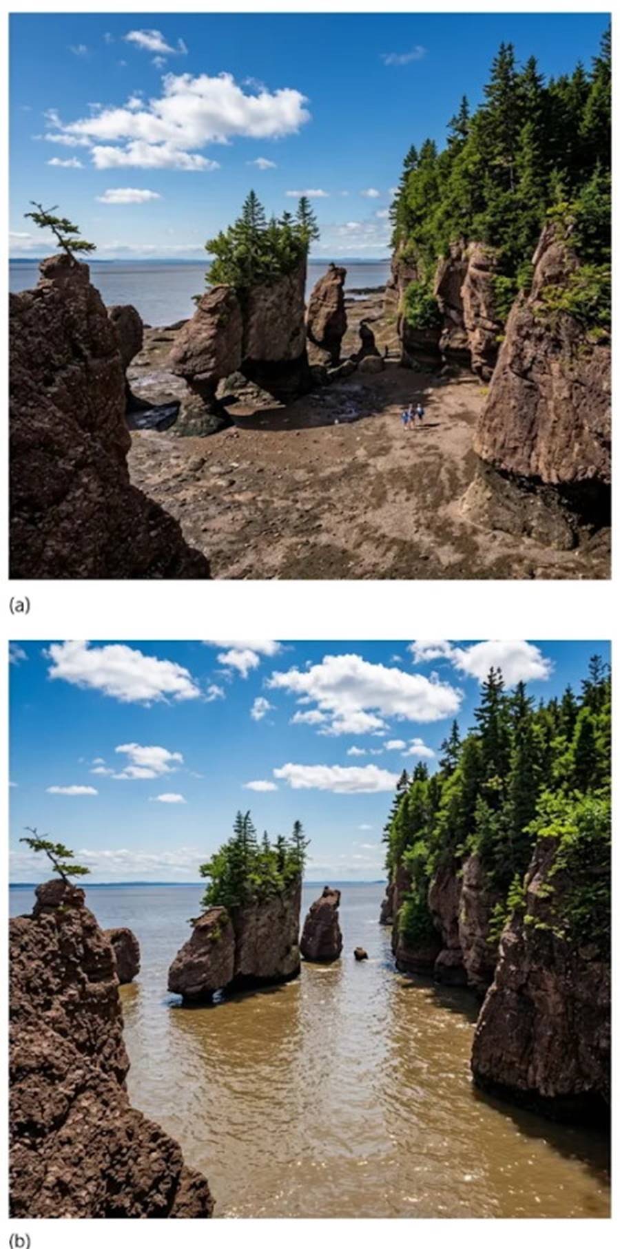
Fig. 10.15. Low tide (a) and high tide (b) at The Rocks Provincial Park, Hopewell Cape, New Brunswick, Canada. The tidal range at the head of the bay exceeds 10 meters.
Date added: 2026-11-09; views: 8;