
Atmospheric Dynamics: Wind Bands, Coriolis Effect, and DMS
Dimethyl Sulfide and Oceanic Cloud Regulation. It is currently estimated that 20 to 40 million tons of sulfur from dimethyl sulfide (DMS) are added to the atmosphere each year. DMS is a gas produced by single-celled, plantlike organisms at the ocean's surface, and it is in part responsible for the characteristic odor of the sea that one notices when approaching the coast from the land. Once in the atmosphere, DMS changes rapidly; one of its main products is sulfur in the form of sulfate, which combines with atmospheric water to form sulfuric acid that is returned to the Earth's surface with the rain (fig. 7.6).
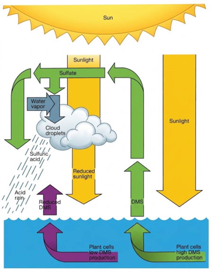
Fig. 7.6. A proposed self-supporting thermal control system linking dimethyl sulfide (DMS) to the sea surface and the atmosphere, a cycle among plants, the Sun, and clouds. Acid rain, pH ~ 3.5, has little impact on seawater because of seawater's carbon dioxide buffer.
The quantities of sulfuric acid returned to the Earth's surface by this process are far below the values associated with the problem of "acid rain." Because DMS forms airborne particles, it plays a role in controlling the density of the clouds that appear over the ocean. Dimethyl sulfide changes the clouds' reflective properties, reduces incoming radiation, and decreases the heating of the ocean's surface (fig. 7.6).
If a DMS buildup results in an excess of clouds and sulfur, less light strikes the sea surface, surface temperatures drop, and the plant production of DMS decreases. This creates a negative feedback loop where reduced DMS production restores clearer skies, demonstrating a complex biological regulation of regional climate.
Winds on a Nonrotating Earth. The heating and cooling of air and the gains and losses of water vapor in air are related to the unequal distribution of the Sun's heat over the Earth's surface, the presence or absence of water, and the variation in temperature of the Earth's surface materials in response to heating. Imagine a model Earth with no continents and with no rotation, but heated like the natural Earth. On this model covered with uniform layers of atmosphere and water, the wind pattern is very simple.
Around the equator, the air, warmed from below, rises. Once aloft, the air flows toward the poles, where it is cooled and sinks to flow back toward the equator. Because of the unequal distribution of the Sun's heat over the model's surface, large amounts of heat and water vapor are transferred to the atmosphere around the equator.
This less-dense air rises, and as it rises it cools; condensation exceeds evaporation, clouds form, and it rains. Equatorial regions are known for their warm, wet climate. The cool dry air remains aloft and flows toward the poles, where it sinks, producing high evaporation, dense air, and a zone of high atmospheric pressure.
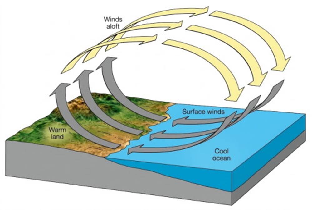
Fig. 7.7. A convection cell is formed in the atmosphere when air is warmed at one location and cooled at another.
Such air movement is shown in figure 7.8; note each hemisphere's two large convective circulation cells, each extending from a pole to the equator. In this model, the Northern Hemisphere surface winds blow from north to south, and the upper winds blow from south to north; in the Southern Hemisphere the reverse is true, with the surface winds blowing from south to north and the upper winds blowing from north to south.
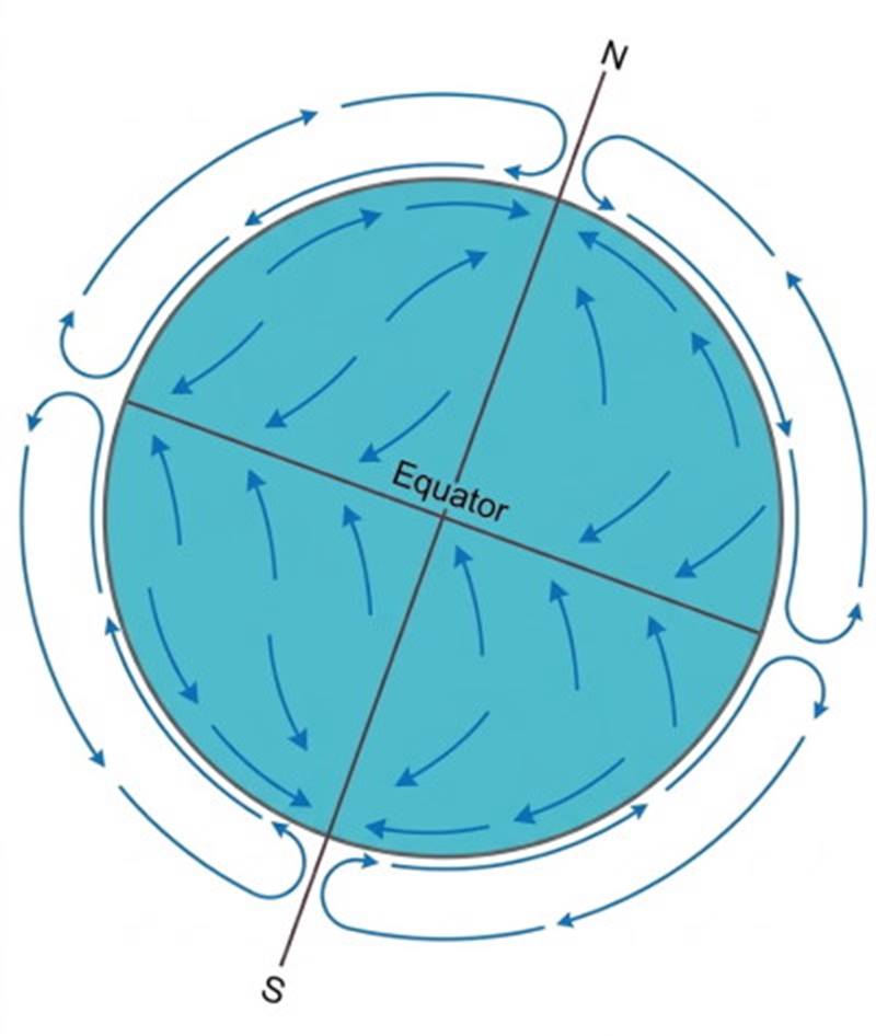
Fig. 7.8. Heating at the equator and cooling at the poles produce a single large convection cell in each hemisphere on a nonrotating water-covered model Earth.
It is important to remember that winds are named for the direction from which they blow. A north wind blows from north to south; a south wind blows from south to north. In this model, the Northern Hemisphere surface winds are north winds, and the Southern Hemisphere surface winds are south winds.
The Effects of Rotation and the Coriolis Effect. Consider next the same model of a water-covered Earth, but with rotation added. In this case, observations of moving parcels are judged relative to coordinates that are fixed to and rotate with the Earth. This rotating coordinate system creates apparent forces that deflect moving bodies.
Gravity holds the Earth's atmosphere captive, but the atmosphere is not rigidly attached to the Earth's surface. There is little or no friction between the Earth's surface and the atmosphere, and the atmosphere moves somewhat independently of the Earth's surface. For example, a parcel of air that appears to be stationary above a point on the equator is actually turning with the Earth and moving eastward at a speed of about 1700 km (1050 mi)/hr.
If a south wind blows this parcel of air due north, it is moved across circles of latitude with progressively smaller circumferences. At these higher latitudes, points on the Earth's surface move eastward more slowly. At 60°N, the eastward speed of a point on the Earth's surface due to rotation is only half the speed at the equator.
For this reason, a parcel of air that was originally moving only northward relative to the Earth at the equator carries with it its equatorial eastward speed so that it is now moving eastward at a speed that is greater than the eastward speed of the Earth's surface at this higher latitude. Therefore, the air parcel is displaced to the east, relative to the Earth's surface, as it moves from low to high latitudes; in the Northern Hemisphere this deflection is to the right of the direction of the air motion.
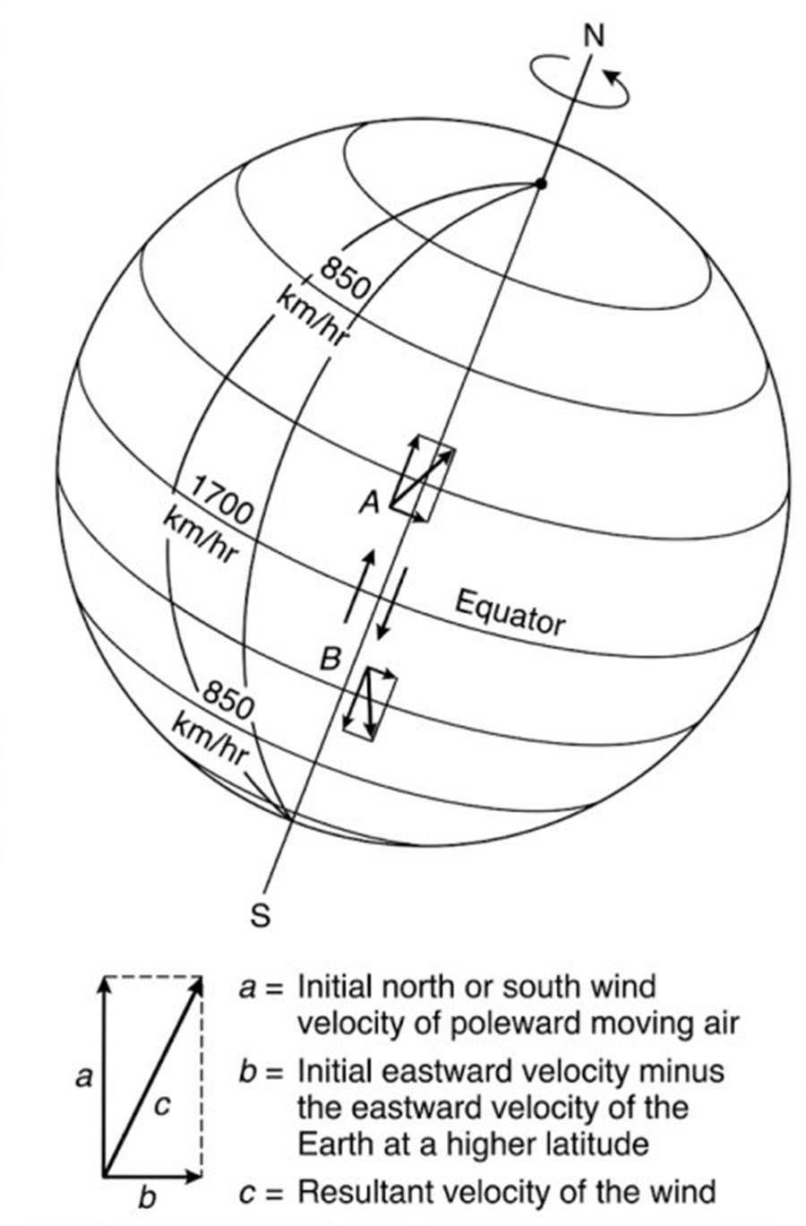
Fig. 7.9. Because air moving northward from the equator to point A carries with it its initial eastward velocity, the air is deflected to the right of the initial wind direction in the Northern Hemisphere. In the Southern Hemisphere, air moving southward to point B is deflected to the left.
This relationship is illustrated in figure 7.9; follow the arrows at A. If the same situation occurs in the Southern Hemisphere, with a parcel of air moving southward from the equator due to a north wind, the deflection is still to the east relative to the Earth's surface. However, this deflection is now to the left of the direction of the air motion. See again figure 7.9 and follow the arrows at B.
If an air parcel moves southward toward the equator in the Northern Hemisphere, then it moves from a latitude where a position on the Earth has a low eastward speed to a latitude where a position on the Earth has a higher eastward speed. These positions move to the east, relative to the air, when the air moves from a higher to a lower latitude. This relationship causes the air to fall behind the position on the Earth, so that the air is moving westward relative to the Earth.
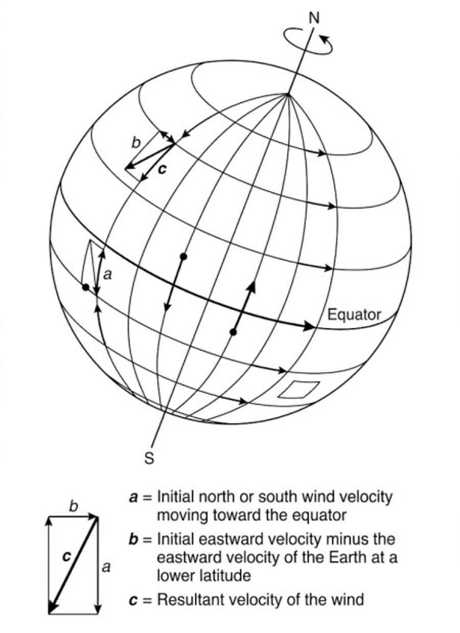
Fig. 7.10. Air moving toward the equator passes from a latitude of lower eastward speed to a latitude of higher eastward speed. The result is deflection to the right of the initial wind direction in the Northern Hemisphere and deflection to the left in the Southern Hemisphere. There is no deflection at the equator.
This pattern is illustrated in figure 7.10. The deflection is still to the right of the direction of motion in the Northern Hemisphere. A similar pattern in the Southern Hemisphere shows that the deflection is to the left of the direction of motion. Deflection due to air moving to the east or to the west is shown in figure 7.11.
Air moving eastward is moving eastward faster than the Earth beneath it, with reference to the Earth's axis. The air is affected by a centrifugal force acting outward from the Earth's axis of rotation that is stronger than the centrifugal force that is acting at the Earth's surface. This small excess force acting on the air is in part acting against the Earth's gravity and in part acting parallel to the Earth's surface directed toward lower latitudes.
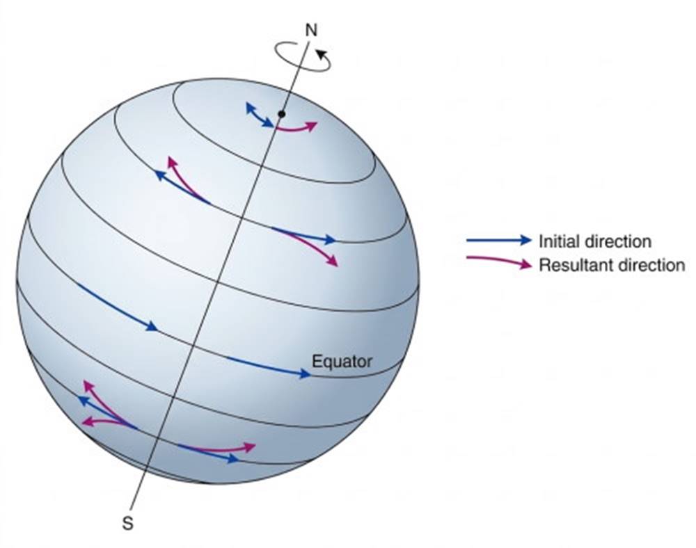
Fig. 7.11. The deflection of eastward-moving and westward-moving air. There is no deflection at the equator.
That part of the centrifugal force acting against the Earth's gravity is so small that it has very little effect. That part acting parallel to the Earth's surface is unopposed and causes a deflection of the moving air to lower latitudes, or to the right of its motion in the Northern Hemisphere. Westward-moving air is moving eastward more slowly, relative to the Earth's surface.
This air is affected by an outward-acting centrifugal force that is weaker than the centrifugal force that is acting at the Earth's surface. Because the centrifugal force acting at the Earth's surface is greater than the centrifugal force acting on the air, there is a weak force acting toward the Earth's axis of rotation. This force is acting in part in the direction of gravity and in part toward higher latitudes.
Note that the deflection continues to be to the right of the initial wind motion in the Northern Hemisphere. In the Southern Hemisphere, the deflection of eastward-moving air toward lower latitudes and of westward-moving air toward higher latitudes results in a deflection of the air to the left of its original direction of motion.
If we were to move from the Earth's surface out into space and were able to watch the motions of Earth and atmosphere, we would see the atmosphere's independent motion and we would also see the Earth turning out from under the moving parcels of air. But we live on a moving Earth's surface and we make our measurements of air motion relative to a coordinate system fixed to this surface. Therefore, from the Earth's surface, we see the moving air parcels deflected from their paths—deflected to the right in the Northern Hemisphere and to the left in the Southern Hemisphere.
The apparent deflection of the moving air relative to the Earth's surface is called the Coriolis effect, after Gaspard Gustave de Coriolis (1792–1843), who mathematically solved the problem of deflection in frictionless motion when the motion is referred to a rotating body and its coordinate system. Because one of the laws of motion in physics tells us that a body set in motion along a straight line continues to move along that straight line unless it is acted upon by a force, such as a push or a pull, the Coriolis effect is often called the Coriolis force. If the term force is used, remember that it is an apparent force, and that a deflection appears only when the motion of an object that is subject to little or no friction is judged against a rotating frame of reference. The magnitude of the Coriolis force increases with increasing latitude, increases with the speed of the moving air, and is dependent on the rotation rate of the Earth on its axis.
Global Wind Bands and Surface Circulation. Applying rotation, and therefore the Coriolis effect, to the stationary model Earth modifies the winds considerably. Refer to figure 7.12 as you read the following description. The air continues to rise at the equator and flows aloft to the north and the south, but it cannot continue to move northward and southward without being deflected to the right in the Northern Hemisphere and to the left in the Southern Hemisphere.
This deflection short-circuits the large, hemispheric, atmospheric convection cells of the stationary model Earth. The deflected air aloft sinks at 30°N and 30°S; it moves along the water-covered surface, either back toward the equator or toward 60°N and 60°S. The upper-level air that reaches the poles cools, sinks, and moves to lower latitudes, warming and picking up water vapor; at 60°N and 60°S it rises again. The result is three convection cells in each hemisphere for the rotating Earth.
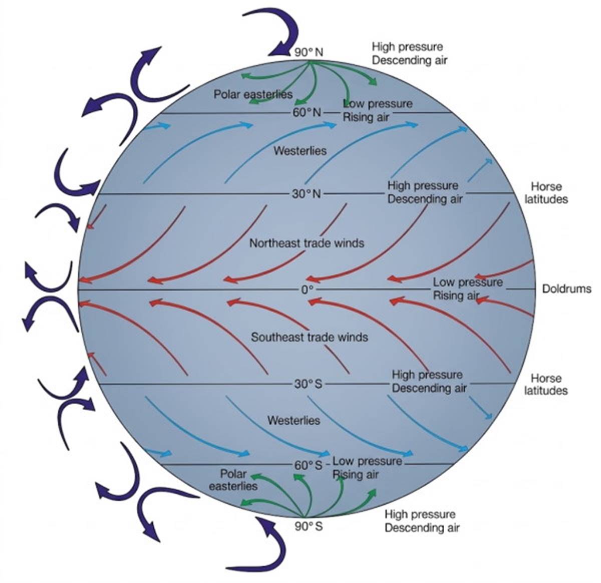
Fig. 7.12. The circulation of the Earth's atmosphere results in a six-band surface wind system.
Consider the flow of surface air in the three-cell system. Between 0° and 30°N and S the surface winds are deflected relative to the Earth, blowing from the north and east in the Northern Hemisphere and from the south and east in the Southern Hemisphere. This deflection creates bands of moving air that are known as the trade winds: the northeast trade winds, north of the equator, and the southeast trade winds, south of the equator.
Between 30°N and 60°N, the deflected surface flow produces winds that blow from the south and west, while between 30°S and 60°S they blow from the north and west. In both hemispheres these winds are called the westerlies. Between 60°N and the North Pole, the winds blow from the north and east, while between 60°S and the South Pole, they blow from the south and east. In both cases they are called the polar easterlies. The six surface wind bands are shown in figures 7.12 and 7.13.
At 0° and 60°N and S, moist, low-density air rises in areas of low atmospheric pressure; these are zones of clouds and rain. Zones of high-density descending air at 30° and 90°N and S are areas of high atmospheric pressure, low precipitation, and clear skies. Wind belts are formed when air flows over the Earth's surface from regions of high atmospheric pressure to areas of low atmospheric pressure. In the zones of vertical motion, between the wind belts, the surface winds are unsteady.
Such areas were troublesome to the early sailors, who depended on steady winds for propulsion. The area of rising air at the equator is known as the doldrums, and the high-pressure areas at 30°N and S are known as the horse latitudes. In all these areas sailing ships could find themselves becalmed for days. The origin of the word doldrum is obscure, but it is likely related to its meaning of a period of low spirits, listlessness, or despondency, feelings often felt by sailors becalmed in this region. The horse latitudes are said to have gotten their name from the stories of ships carrying horses that were thrown overboard when the ships were becalmed and the freshwater supply became too low to support both the sailors and the animals.
Satellite Scatterometry and Ocean-Atmosphere Coupling. Every day for decades, thousands of measurements of air pressure, wind speed, and wind direction have been taken by meteorological stations on land and by ships and buoys at sea. These data are converted into atmospheric wind and pressure charts that are used to make the world's weather forecasts. Satellites can provide another way to report wind velocities at the Earth's surface. Microwave radar signals sent from the satellite are scattered by the waves at the Earth's surface and returned to the satellite. These returned signals are then interpreted as measurements related to the speed and direction of the surface winds.
The radar signals are sent and received by an instrument called a scatterometer, which is carried by the satellite. The first scatterometer was sent into space in the late 1970s aboard the satellite SEASAT. The most recent model, NASA Scatterometer (NSCAT), went into space on Japan's Advanced Environmental Orbiting Satellite (ADEOS) in August 1996, but ADEOS remained active only until June 1997.
For eight-and-a-half months, NSCAT measured surface wind data that were verified by data from ships and buoys (see fig. 7.13). Such data are not only valuable for weather forecasting but also yield data that can be used in computer models that couple the ocean and atmosphere, enabling meteorologists and oceanographers to investigate and better understand the couplings of the ocean-atmosphere system.
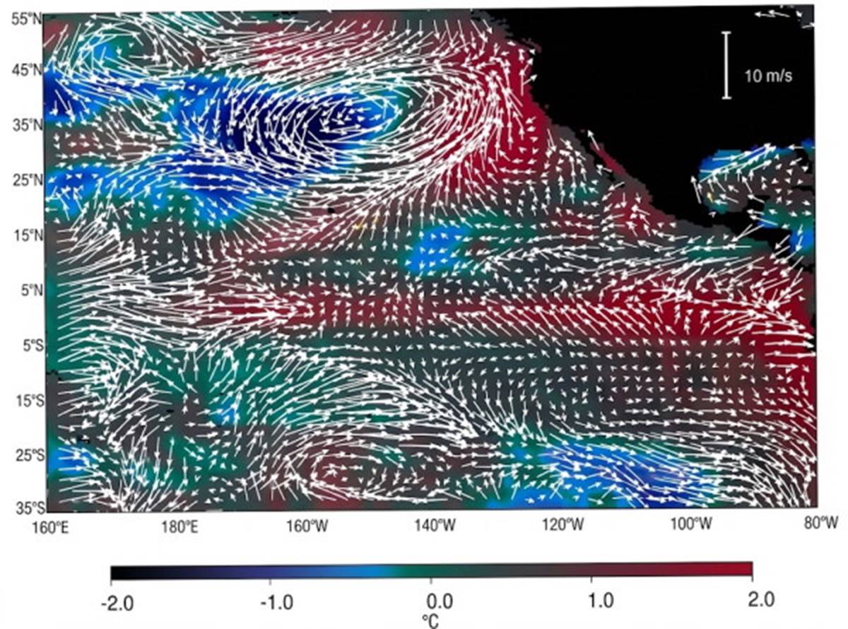
Fig. 7.13. Surface wind anomalies (white arrows) measured by NASA's high-resolution scatterometer (NSCAT) are superimposed on the map of sea-surface temperature anomalies (colors) derived from advanced very high resolution radiometer (AVHRR) measurements. The white arrows and colors indicate the deviation of winds and sea-surface temperatures from the average conditions present for the period May 22–31, 1997. Notice the elevated temperature (red) in the eastern Pacific due to El Niño conditions and the weak and reversed trade winds in the same area.
Date added: 2026-11-09; views: 3;