
Diurnal Cycles of the Boundary Layer and Surface Meteorology
The diurnal heating and cooling of the surface imparts a diurnal cycle to the boundary layer (Figure 14.3). At night, the surface cools by longwave emission and the boundary layer becomes stable with weak turbulent motions. This temperature inversion typically extends to a height of 100-500 m. Above this inversion lies a residual weak mixed layer that is remnant from the previous day. Upon sunrise, surface heating by solar radiation produces upward exchange of sensible heat from the surface and warms the boundary layer. The nocturnal temperature inversion erodes and is replaced with a convective mixed layer. On a hot, sunny day, strong surface heating causes the boundary layer to become strongly unstable over land, and the turbulent motions increase the depth of the boundary layer to 1-2 km or more by late afternoon. Thereafter, surface heating is no longer sufficient to maintain the mixed layer through turbulent motions. The boundary layer collapses, and after sunset the surface cools and the nocturnal inversion develops. The inversion deepens over the course of the night.
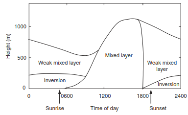
Fig. 14.3. Typical diurnal cycle of the boundary layer. redrawn from oke (1987, p. 72)
The diurnal cycle is readily evident in the surface layer. Figure 14.4 shows observed diurnal cycles of solar radiation, temperature, relative humidity, and wind for several summer days in Colorado. Solar radiation has a pronounced diurnal cycle. Peak values typically occur near noon, but there is considerable variability as clouds pass overhead (e.g., July 25). Air temperature varies in relation to solar radiation. Coldest temperatures typically occur near sunrise; warmest temperatures occur in middle to late afternoon. Clouds reduce solar radiation and reduce surface warming (compare July 23 and 28). Conversely, nighttime clouds reduce surface cooling by reradiating terrestrial longwave radiation back onto the surface. Clouds, therefore, diminish the diurnal temperature range (i.e., the difference between daily maximum and minimum temperatures). Relative humidity has a strong diurnal cycle.
The amount of water vapor in the air often is lowest early in the morning, increasing to a maximum during daylight hours when evapotranspiration moistens the atmosphere. However, relative humidity is generally low during the day and increases at night when the colder air holds less water at saturation. Wind speed also has a diurnal cycle. Heating of the surface during the day provides buoyant energy that mixes the near-surface air and creates winds. At night, longwave emission of radiation cools the surface. The near-surface air becomes stable, with cold, dense air trapped near the surface. These conditions suppress turbulence and vertical mixing. Hence, winds over land normally reach maximum speeds in early afternoon and decrease at night.
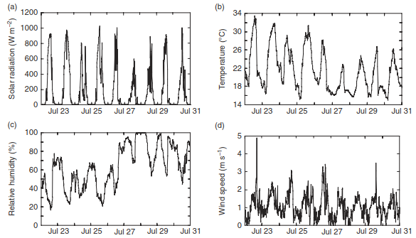
Fig. 14.4. Diurnal variation in (a) solar radiation, (b) air temperature, (c) relative humidity, and (d) wind speed measured in Boulder County, Colorado, July 23–31, 1997
Precipitation can also have a strong diurnal cycle. Air near the ground rises as it warms during the day. The rising air cools, and water vapor condenses into clouds. If conditions are right and clouds grow large enough, rain occurs in the form of afternoon thunderstorms. In the United States, precipitation has a large diurnal cycle over many areas, especially during warm seasons (Dai et al. 1999a, 2007). The strongest diurnal cycle occurs in summer in the Rocky Mountain region and in southeastern states. In these locations, it is more than twice as likely to rain during summer from 1500 to 1800 hours than any other time of day.
The diurnal heating of land varies seasonally and geographically depending on variations in solar geometry, cloudiness, and the amount of dust, pollution, and moisture in the air. Arid regions generally have a large diurnal temperature range. The dry air allows penetration of solar radiation through the atmosphere and provides little longwave heating at night. In humid regions, the hazy sky prevents strong solar heating during the day and warms temperature at night so that diurnal temperature range is small. Coastal areas have a small diurnal temperature range because of the moderating influence of water. Clouds have a large effect on diurnal temperature range (Dai et al. 1999b). Clouds reduce daytime heating by decreasing the amount of solar radiation that reaches the ground and warm nighttime temperatures by enhancing downward longwave radiation. Wet soils also reduce diurnal temperature range by increasing daytime evaporative cooling. As soils dry, evapotranspiration decreases and daytime temperatures become hotter as a result of the decreased cooling (Durre et al. 2000; Seneviratne et al. 2010; Hirschi et al. 2011; Mueller and Seneviratne 2012).
Date added: 2026-09-24; views: 2;