
Mesoscale Atmospheric Circulations Induced by Surface Heterogeneity
1. Theoretical Foundations of Land–Atmosphere Interactions. Spatially heterogeneous vegetation and soil moisture exert a profound influence on boundary layer structure and can generate mesoscale atmospheric circulations. As demonstrated in early land surface modeling work (Giorgi and Avissar 1997; Avissar et al. 2004; Pielke et al. 2011), the primary mechanism behind this land–atmosphere coupling lies in differential surface energy fluxes and localized atmospheric heating.
The partition of incoming radiant energy into sensible heat flux and latent heat flux is governed by surface moisture availability. Dry surfaces lack sufficient water for sustained evapotranspiration, leading to a dominant sensible heat flux and low latent heat flux. Consequently, the overlying air mass becomes warm and dry. Conversely, wet or well-irrigated surfaces exhibit high latent heat fluxes, maintaining cool and moist atmospheric conditions above them.
The contrast in energy partitioning creates sharp horizontal temperature and pressure gradients. These gradients are particularly pronounced in semiarid climates, where irrigated or moist agricultural land is interspersed within a predominantly dry background landscape (Anthes 1984; Mahfouf et al. 1987; Segal et al. 1988; Avissar and Pielke 1989; Segal and Arritt 1992; Taylor et al. 2007).
2. Mechanisms of Thermal Circulations and Albedo Variation. Spatial heterogeneity frequently manifests where patches of irrigated croplands are embedded within expanses of dry native grasses. In these landscapes, the horizontal surface flux contrast drives a local circulation pattern analogous to a classic sea breeze. Lower-level surface winds blow from the cooler, wet cropland toward the warmer, dry grassland, while return winds aloft flow in the opposite direction.
Beyond moisture contrasts, localized variations in surface albedo can independently initiate thermal circulations (Pielke et al. 1993). Early meteorological proposals highlighted this energy balance manipulation; for instance, coating large coastal arid zones with asphalt was suggested as a method to artificially induce local convergence and enhance regional rainfall (Black and Tarmy 1963; Black 1963).
3. Atmospheric Model Simulations and Mesoscale Dynamics. Numerical experiments using high-resolution mesoscale atmospheric models provide a detailed quantitative picture of how vegetation contrasts restructure the lower atmosphere. In a canonical experiment modeled after Seth and Giorgi (1996), a control simulation of a uniform, homogeneous wet forest is compared against an experimental setup featuring a 200-km patch of dry grassland surrounded by wet forest.
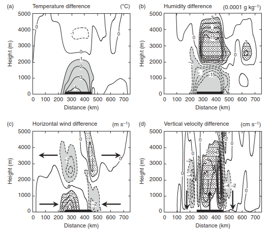
Fig. 1. Mesoscale circulations created by wet and dry vegetation on a summer day. Data show the difference (experiment minus control) between a simulation with a patch of dry grasses surrounded by wet trees (experiment) and a control simulation with homogenous wet trees. The dry grass extends from x = 250 to 450 km (thick horizontal line). Data are shown as a two-dimensional cross-section of height (left axis) and west-to-east distance (bottom axis). (a) Air temperature. Shading denotes warming greater than 1°C. (b) Specific humidity. Stippling denotes increases and shading denotes decreases. (c) Horizontal zonal (west-to-east) wind. Positive values (stippling) indicate westerly wind. Negative values (shaded) indicate easterly wind. The four large arrows show wind direction along the surface and aloft. (d) Vertical velocity. Positive values (stippling) indicate rising motion. Negative values (shaded) indicate descending motion. The three large arrows indicate direction of motion. Adapted from Seth and Giorgi (1996).
The primary numerical results demonstrate substantial shifts in boundary layer dynamics over the dry grassland domain:
· Temperature Perturbations: Shifted energy partitioning reduces latent heat in favor of sensible heat, raising lower-atmosphere temperatures over the dry grassland by 1–4 °C relative to the homogeneous forest background.
· Circulation Cells: Differential heating establishes two counter-rotating cells that converge directly over the warm patch. The cell on the western margin rotates counter-clockwise (westerly surface wind, easterly wind aloft), whereas the eastern margin cell rotates clockwise.
· Vertical Motion & Moisture Transport: Strong updrafts form over the warm grassland center, flanked by localized subsidence on either side. This secondary circulation advects moist air inward from the surrounding forest and pumps it vertically, enriching the upper atmospheric layers with moisture.
Regional Precipitation Regimes and Land-Use Impacts. By creating spatial gradients in surface heating, complex vegetation mosaics directly modulate cloud dynamics and regional convective precipitation (Chen and Avissar 1994; Pielke et al. 1997; Baidya Roy and Avissar 2002).
Real-world landscape studies, such as those focusing on northern Georgia—a regional mosaic of dense forest and active agricultural land—illustrate the practical importance of these mechanisms. Mesoscale model simulations comparing an idealized, homogeneous forest against the actual heterogeneous landscape (across a 210 km × 210 km domain) highlight clear operational differences (Pielke et al. 1997):
1. Heterogeneous Landscapes: Moist forest zones with elevated latent heat flux juxtaposed with drier agricultural plots promote rapid destabilization. On typical summer days, this arrangement triggers large cloud formations by early afternoon, leading to widespread convective precipitation.
2. Homogeneous Landscapes: Uniform vegetation exhibits delayed and diminished convective activity, with cloud initiation occurring significantly later in the afternoon.
Similar modeling in west Texas confirms that convective initiation depends heavily on the specific configuration of surface vegetation (Pielke et al. 1997). Simulations for late spring conditions show that a varied landscape containing crops, forest patches, and shortgrass prairie produces larger cloud fields, more vigorous precipitation, and higher near-surface moisture than a uniform shortgrass landscape. These findings underscore how land-use changes alter boundary layer physics and mesoscale weather patterns.
Date added: 2026-09-24; views: 1;