
Land Surface and Earth System Models: Coupling and Evaluation
Coupling Experiments in Land-Atmosphere Systems. Paired climate model simulations provide a foundational methodology for isolating the specific impacts of land surface processes on climate systems. As illustrated in Fig. 25.11, these experiments systematically introduce land surface modifications by altering datasets—such as leaf area index or land cover—or by implementing alternative parameterizations for processes like stomatal conductance and soil water dynamics. A standard experimental setup compares a baseline simulation using current vegetation cover against a secondary simulation incorporating modified land cover. The difference between these two simulated states quantifies the isolated effect of the modified land surface on regional and global climatology.
Atmosphere models operate with short temporal integration steps to solve numerical governing equations, typically requiring time steps of 30 minutes or less for coarse-resolution global climate models and even shorter steps for high-resolution numerical weather prediction models. While numerical weather prediction studies integrate over short windows of several days or weeks, climate simulations require multi-decadal integrations—often 20 years or more—to establish statistically robust land surface impacts on simulated climate regimes. Numerous climate model simulations demonstrate that climate exhibits marked sensitivity to soil moisture and snow storage at seasonal to interannual timescales. Vegetation properties, specifically leaf area index, surface roughness, rooting depth, and stomatal conductance, play a major role in dictating climate patterns. Land cover transformations driven by natural vegetation dynamics or anthropogenic land use alter these surface characteristics and drive climate shifts. Key research domains include desert greening in response to enhanced rainfall, shift dynamics across the boreal forest-tundra ecotone under changing climate conditions, and human-driven perturbations such as tropical deforestation, dryland overgrazing, and temperate forest clearing for agriculture.
Evolution and Architecture of Earth System Models. Earth system models extend classical climate models by coupling models of the terrestrial biosphere with global climate models to evaluate interactive terrestrial ecosystem feedbacks. An early methodology used to achieve this integration is asynchronous equilibrium coupling, which leverages equilibrium relationships between climate and biogeography to iteratively adjust vegetation cover.
- 1st stage: Asynchronous Coupling Mechanics. As shown in Fig. 25.12a, an initial climate simulation is executed using a baseline vegetation cover. The resulting climate variables drive a biogeography model (such as the Holdridge vegetation model) to predict a new geographic distribution of vegetation. This updated vegetation field is then fed back into the climate model to compute an updated climate state. This iterative process between the climate model and biogeography model repeats over multi-year steps until the system converges on a stable, equilibrium vegetation distribution.
- 2nd stage: Synchronous Dynamic Coupling Integration. Modern Earth system models utilize integrated synchronous coupling, depicted in Fig. 25.12b, which bridges long-timescale vegetation dynamics with short-timescale physiological and hydrometeorological processes. Coupled biosphere-atmosphere models integrate traditional biogeophysics and hydrometeorology with biogeochemical schemes to simulate carbon cycling in relation to climate dynamics. Dynamic global vegetation models simulate plant community composition, vegetation structure, and demographic dynamics directly within the climate loop. Climate conditions determine energy exchange, water availability, ecosystem productivity, and geographic distribution across plant functional types (e.g., trees versus grasses, needleleaf versus broadleaf, evergreen versus deciduous). In return, terrestrial biomass and leaf area index regulate land-atmosphere exchanges of energy, water, momentum, and CO₂. Initial experiments highlighted strong biogeophysical feedbacks, such as tree expansion into Arctic tundra or desert greening in North Africa, both of which lower surface albedo. Furthermore, coupled carbon cycle-climate simulations reveal substantial biogeochemical feedbacks that alter atmospheric CO₂ concentrations.
Process Scope and Scaling in Terrestrial Models. Dynamic global vegetation models operate across distinct temporal scales to simulate coupled biogeophysical, biogeochemical, and ecosystem processes. Fig. 25.13 illustrates the process linkages and structural scope of these models, using concepts from the Lund-Potsdam-Jena (LPJ) dynamic global vegetation model.
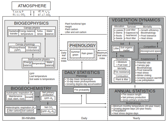
Fig. 25.13. Scope of a dynamic global vegetation model for use with climate models illustrating the linkages among biogeophysics, biogeochemistry, and vegetation dynamics. The lightly shaded biogeophysical processes represent the traditional hydrometeorological scope of land surface models. The darker boxes represent the greening of land surface models with the introduction of dynamic vegetation. Reproduced from Bonan et al. (2003).
Short-timescale processes occurring on the order of minutes to hours govern energy, water, momentum, and CO₂ exchanges between the land and atmosphere. Canopy physics, soil physics, and plant physiology act interdependently to control surface energy fluxes, microclimatic conditions, and carbon uptake. Intermediate daily processes link these physical fluxes to leaf phenology, which responds dynamically to variations in temperature and soil moisture. Long-timescale processes operating over years or decades drive structural ecosystem changes, including net primary production allocation to plant tissues, tissue turnover, disturbance from wildfire, and plant mortality. Plant functional type success is determined by functional traits, including phenological strategy, leaf morphology, photosynthetic pathway (C₃ versus C₄), and climate tolerances. Biomass growth and tissue allocation connect directly to soil biogeochemistry via litterfall, organic matter decomposition, and nitrogen availability. Contemporary model developments incorporate advances in plant demography, ecosystem dynamics, and continuous trait variation within plant functional types in response to climate gradients.
Anthropogenic Processes and Biogeochemical Frontiers. Terrestrial models are actively expanding to incorporate human activities that transform the land surface. Urban land cover parameterizations simulate urban canopy energy balances, surface heat island effects, and altered hydrologic cycles. Crop models simulate agricultural growth, phenological development, harvesting, and management practices—such as irrigation and synthetic fertilizer application—in response to meteorological forcing. Additional developments account for forest management and wood harvesting to capture anthropogenic carbon cycle perturbations.
Simultaneously, models are expanding their representation of complex biogeochemical interactions and reactive gas emissions:
· Biogenic Volatile Organic Compounds (BVOCs): Models incorporate empirical and photosynthesis-based emission routines for isoprene, monoterpenes, and other trace organic compounds.
· Wildfire and Aerosol Dynamics: Global fire models explicitly link burn severity and fuel loads to biogeochemical cycles, vegetation mortality, and atmospheric chemical emissions. Dust mobilization modules parameterize mineral dust entrainment, which forms a major component of global aerosol radiative forcing.
· Ozone Interactions: Tropospheric ozone exposure parameterizations simulate stomatal damage and subsequent reductions in photosynthetic productivity.
· Coupled Carbon-Nitrogen-Phosphorus Cycles: Modern terrestrial models integrate coupled carbon-nitrogen biogeochemistry to account for nitrogen deposition, biological nitrogen fixation, denitrification, and leaching. Emerging frontiers are further introducing phosphorus limitations to constrain terrestrial carbon sink estimates.
· Wetlands and Permafrost Dynamics: Specialized modules represent wetland hydrology, atmospheric methane emissions, permafrost thaw energetics, vertically resolved soil carbon profiles, and stable isotope fractionations (carbon and water).
An additional structural development involves transitioning from traditional rectangular latitude-longitude grid cells to irregular catchment-based watershed networks. Watershed-based land surface models define hydrological catchments as fundamental computational units, enabling a more realistic physical representation of runoff, streamflow, and basin-scale water storage.
Model Evaluation, Benchmarking, and Uncertainty Analysis. The increasing complexity of Earth system models presents major opportunities and challenges for systematic model evaluation across spatial and temporal scales. Carbon and water flux predictions are routinely evaluated using transient 20th-century simulations, long-term ecosystem experiments, and observational networks.
Fig. 25.14 demonstrates a process-level model evaluation comparing simulated net primary production against annual precipitation for two biogeochemical models (CASA' and CN) coupled to the Community Land Model.
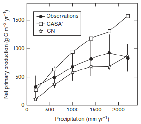
Fig. 25.14. Simulated net primary production for two biogeochemical models (CASA' and CN) coupled to the Community Land Model compared with observations. Net primary production is shown in relation to annual precipitation. Vertical bars show observational uncertainty. From Randerson et al. (2009).
Model intercomparisons reveal substantial uncertainties across contemporary Earth system models. Present-day carbon cycle representations vary widely, as shown in Fig. 25.15. Across 18 Earth system models evaluated for present-day conditions, global soil carbon estimates vary by a factor of six, while total vegetation carbon varies by a factor of three.
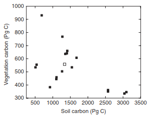
Fig. 25.15. Global vegetation and soil carbon simulated by 18 Earth system models for present-day. The open symbol shows observational estimates. Adapted from Anav et al. (2013).
To address these discrepancies, researchers employ model-data fusion techniques—such as parameter estimation and data assimilation—to optimize model parameters against observations, quantify output uncertainty, and identify key data deficiencies. Rigorous model evaluation requires multi-scale data synthesis:
- Leaf Scale: Photosynthetic capacity metrics (such as maximum carboxylation rate, V_cmax) are benchmarked against global leaf trait databases.
- Canopy Scale: High-frequency exchange fluxes of heat, water, and CO₂ are evaluated using eddy covariance flux tower networks.
- Global Scale: Model performance is assessed against empirically upscaled flux products, global soil carbon databases, and long-term litter decomposition experiments to ensure physical and biological consistency across scales.
Date added: 2026-09-24; views: 1;