
The Terrestrial Water Balance and Soil Water Bucket Models
The complexities of the hydrologic cycle on land can be reduced to a simple form in which the change in soil water (ΔS) is the balance between water input from precipitation (P), water loss from evapotranspiration (E), and water lost as runoff (R). Mathematically, ΔS = P - E - R. Thornthwaite and Mather (1955, 1957) used this equation in a simple bucket model of monthly root zone soil water (Figure 10.8a). The soil is treated as a bucket with a maximum water-holding capacity. Precipitation fills the bucket, and evapotranspiration depletes the bucket. Any water in excess of the maximum water-holding capacity overflows the bucket and is lost as runoff. Potential evapotranspiration is calculated from Eq. (10.1) and reduced to actual evapotranspiration based on the ratio of soil water to maximum water-holding capacity.
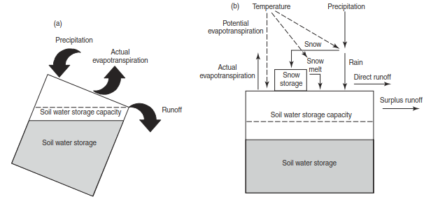
Fig. 10.8. Schematic representation of (a) a bucket model with the water balance ΔS = P − E − R (thornthwaite and Mather 1955, 1957) and (b) a more detailed water balance model (McCabe and Wolock 2011a)
Figure 10.9 illustrates this methodology applied over a 12-month period using the bucket model of Mintz and Walker (1993). From January to May and again from September to December, soil water does not limit evapotranspiration so that actual evapotranspiration equals potential evapotranspiration. In these months, evapo- transpiration is less than precipitation and the excess precipitation runs off. In June, July, and August, soil water limits evapotranspiration to less than the potential rate. There is no runoff in these months, because water loss from evapotranspiration balances water input from precipitation.
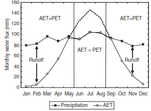
Fig. 10.9. Monthly water balance. runoff is the difference between precipitation and actual evapotranspiration (aet). The dashed line shows potential evapotranspiration (pet). In other months, aet = pet
Figure 10.10 shows annual P - E for the United States calculated by this method. The eastern half of the United States, except southern Florida, has a large surplus of water. The Pacific Northwest, where annual precipitation is high, and parts of the mountainous West, where cold temperatures reduce evapotranspiration, also have large water surplus. The least surplus water occurs in the hot, arid Southwest.
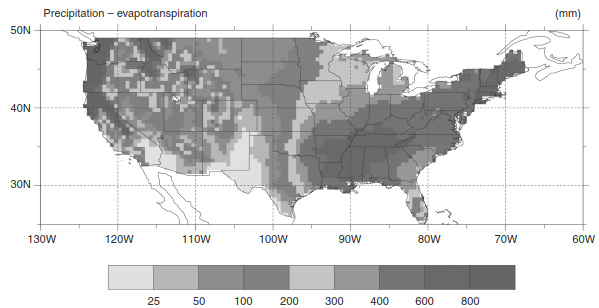
Fig. 10.10. Geographic distribution of the difference between annual precipitation and evapotranspiration in the United States. evapotranspiration is based on the water balance model of figure 10.9 using monthly temperature and precipitation climatologies (Legates and Willmott 1990a,b) and observed soil water-holding capacity (rosenbloom and Kittel 1996). See color plate section
Other water balance models follow the same principles, but represent more physical processes. For example, the monthly water balance model of McCabe and Wolock (2011a,b) additionally temporarily stores water as snow (Figure 10.8b). Precipitation is partitioned as rain or snow based on temperature. This snowfall accumulates and melts at a rate determined by temperature. Runoff is generated from infiltration-excess overland flow and additionally from surplus soil water. Monthly temperature and precipitation are climate inputs to the model. Seven site-specific inputs are: daylength (used in potential evapotranspiration); rain and snow threshold temperatures; the maximum snow melt rate; the fraction of rainfall that becomes direct runoff; the fraction of surplus water that becomes runoff; and soil water storage capacity.
Date added: 2026-09-24; views: 1;